
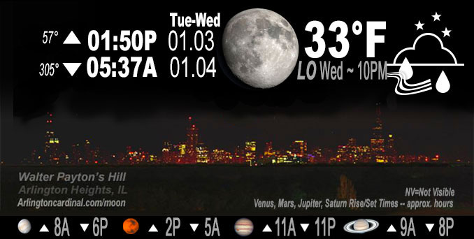
🌔 🌕 🌗 🌑 Waxing Gibbous Moon, sky cover overnight Tue. to Wed. 100% to 55% to 80%, winds NE to ENE, 5 to 8 MPH, G13 to 16 to 14 MPH, Low 33, 10p to 12a
NWS CHGO | NWS HRLY | /NWSchicago | 🌡
ARLINGTON HEIGHTS WEATHER
▴ forecast7 (Arl. Hts.) | RADAR | WIDE RADAR
IMPORTANT NOTE ON NWS DATA
======================
NIGHT FORECASTS …
NOTE 1: Forecast and information text below may refer to a previous night on Arlingtoncardinal.com, and might not be updated until late afternoon, evening, or overnight. However, Night Sky archives on CARDINAL NEWS Magazine include text forecasts that correspond to the lunar phase graphic above.
NOTE 2: Keep in mind lunar rise and set times don’t always correspond with night weather and early morning lows because on some days during the month the moon is visible in the sky predominantly during the daytime hours.
Overnight Tuesday/Wednesday …
Weather Hazards expected …
Limited Severe Thunderstorm Risk southeast of I-55.
Elevated Fog Risk mainly north of I-80.
Dense Fog Advisory
DISCUSSION…
Areas of fog may become dense through this evening. Locations north of I-80 are most favored for persistent dense fog.
Scattered thunderstorms are possible across the area through early evening, any of which could have small hail. One or two of these may reach marginal severe limits south of the Kankakee River Valley, with the primary threat being wind gusts to 60 mph. A brief tornado is also possible.
Hello mobile users! If you encounter mobile “unfriendly” weather page, turn your phone sideways for a better view.
======================
DENSE FOG ADVISORY …
Dense Fog Advisory URGENT – WEATHER MESSAGE National Weather Service Chicago IL 507 PM CST Tue Jan 3 2023
Ogle-Lee-De Kalb-Kane-DuPage-La Salle-Kendall-Grundy-Central Cook- Southern Cook-Northern Will- Including the cities of Rochelle, Oregon, Byron, Dixon, DeKalb, Sycamore, Aurora, Elgin, Naperville, Wheaton, Downers Grove, Lombard, Carol Stream, Ottawa, Streator, La Salle, Mendota, Marseilles, Oswego, Yorkville, Plano, Morris, Coal City, Minooka, Chicago, Cicero, Oak Lawn, Oak Park, La Grange, Calumet City, Oak Forest, Lemont, Orland Park, Park Forest, Joliet, Bolingbrook, Plainfield, and Mokena 507 PM CST Tue Jan 3 2023
…DENSE FOG ADVISORY REMAINS IN EFFECT UNTIL 9 PM CST THIS EVENING…
* WHAT…Visibility one quarter mile or less in dense fog.
* WHERE…Portions of north central and northeast Illinois.
* WHEN…Until 9 PM CST this evening.
* IMPACTS…Hazardous driving conditions due to low visibility.
PRECAUTIONARY/PREPAREDNESS ACTIONS…
If driving, slow down, use your headlights, and leave plenty of distance ahead of you.
O’HARE FORECAST …
Forecast Beginning Tuesday Night, Jan. 03, 2023 …
Tuesday Night: A 30 percent chance of showers, mainly before 9pm. Areas of dense fog before midnight. Otherwise, mostly cloudy, with a low around 37. Southwest wind 5 to 10 mph, with gusts as high as 15 mph.
Wednesday: A slight chance of drizzle and snow after noon. Cloudy, with a high near 38. Southwest wind 10 to 15 mph, with gusts as high as 20 mph. Chance of precipitation is 20%.
Wednesday Night: Scattered snow showers. Cloudy, with a low around 31. Southwest wind around 10 mph, with gusts as high as 20 mph. Chance of precipitation is 30%.
Thursday: A 40 percent chance of snow. Cloudy, with a high near 36. West southwest wind around 10 mph, with gusts as high as 15 mph.
Thursday Night: Mostly cloudy, with a low around 30. West wind 5 to 10 mph.
Friday: Mostly cloudy, with a high near 36.
Friday Night: A 30 percent chance of snow after midnight. Mostly cloudy, with a low around 30.
Saturday: A chance of snow. Mostly cloudy, with a high near 37.
Saturday Night: Mostly cloudy, with a low around 28.
Sunday: Partly sunny, with a high near 37.
Sunday Night: Partly cloudy, with a low around 27.
Monday: Mostly sunny, with a high near 37.
Monday Night: Partly cloudy, with a low around 28.
Tuesday: Partly sunny, with a high near 39.
O’Hare forecast archive and hourly weather observations archive are available HERE on the CARDINAL NEWS Magazine.
Arlingtoncardinal.com/moonphases
Arlingtoncardinal.com/nightsky
NIGHT SKY THIS MONTH …
Check the night sky objects for this month and past months in the playlist from the Space Telescope Science Institute YouTube channel Backyard stargazers get a monthly guide to the northern hemisphere’s skywatching events with “Tonight’s Sky” (Musical track The Far River written by Jonn Serrie, from the album And the Stars Go With You courtesy of New World Music Ltd. Musical track The Far River written by Jonn Serrie, from the album And the Stars Go With You courtesy of New World Music Ltd).
Telephoto lens, ISO 100, f/11, Shutter Speed 1/100 to 1/125 for the Moon.
Get updates from The Cardinal ALL NEWS FEEDS on Facebook. Just ‘LIKE’ the ‘Arlington Cardinal Page (become a fan of our page). The updates cover all posts and sub-category posts from The Cardinal — Arlingtoncardinal.com. You can also limit feeds to specific categories. See all of The Cardinal Facebook fan pages at Arlingtoncardinal.com/about/facebook …
Help fund The Cardinal Arlingtoncardinal.com/sponsor
Telephoto lens, ISO 1600, f/11, Shutter Speed 2.5″ for the skyline. The skyline exposure was toned down, and brightness and contrast was adjusted in Photoshop.
Area Forecast Discussion
National Weather Service Chicago/Romeoville, IL
551 PM CST Tue Jan 3 2023
.SHORT TERM… Issued at 249 PM CST Tue Jan 3 2023
Through Wednesday night…
Key forecast concerns… *Lingering fog through this evening, possibly dense at times
*Showers and thunderstorms along cold front this afternoon, a few strong to severe storms possible mainly south and east of I-55
A broad surface low continues to be analyzed over central Iowa with a warm front stretching eastward across northeastern Illinois into northwestern Indiana and a cold front stretching southward across eastern Iowa into eastern Missouri and western Illinois. As the warm front continues to slowly move northward the cold front is expected to continue to catch up to the warm front and gradually occlude the system through this evening. As the system occludes the ongoing fog is expected to gradually move northward and lift as drier air tries to filter in from aloft. While there is some uncertainty as to how quick this would occur, guidance continues to favor the late evening and early overnight period before fog begins to lift out of the area. In the mean time expect the fog to persist through the evening and be dense at times with visibilities as low as a quarter mile possible. Be sure to leave extra time and use caution when traveling this evening.
Additionally, the occluded front will also help to generate scattered showers and thunderstorms through the rest of the afternoon and into the early evening. Currently there is line of showers and embedded thunderstorms that is moving northeastward across northeastern Illinois which has a history of producing some small hail. This area of showers and storms is north of the aforementioned warm front where instability is more elevated which should limit the overall severity of this storm as it continues to move towards Lake Michigan. However, as the cold front sweeps into the area this evening additional showers and storms are expected to develop in the warm sector which currently is being analyzed south of I-80 where temperatures and dew points have climbed into the upper 50s and lower 60s. Forecast soundings have continued to show that decent instability of 500 to 700 J/kg of CAPE to be present in this area with steep mid-level lapse rates and decently strong wind shear. Given that we are in early January, these conditions are sufficient to possibly get a couple of strong to severe thunderstorms during the mid to late afternoon and early evening hours. Since the wind shear profiles are predominantly unidirectional the primary threat with any severe storms would be gusty winds and some small hail, but if any storms are able to develop near the warm front some better helicity may allow storms to rotate and have the potential to produce a brief tornado. While the tornado potential is there it is still rather low. There continues to be a marginal risk (level 1 of 5) for this severe potential across our southeastern CWA mainly for areas south and east of I-55 which lines up well where the better environment looks to be developing.
Once the front clears the area this evening, showers and storms will come to an end and leave mostly dry conditions for the rest of the night. However, cooler air moving in behind the front will allow temperatures to drop into the low to mid-30s by Wednesday morning.
Stratus will blanket the area through Wednesday night as the upper low stalls/drifts along the IA/MN line. Saturated depths should be sufficient for light precip generation amid deep cyclonic flow, especially toward the northwest CWA by late morning. Only modest CAA into the area will limit the temp decline in the saturated cloud layer, which will delay better ice introduction until as least the afternoon. Most precip in the morning across northern Illinois should be limited to drizzle mixed with some poor quality snow. Light snow should become the more dominant precip type through the afternoon as precip potential expands across the remainder of the CWA. An embedded trough rotating around the low will then bring enhanced light snow chances across much of the area Wednesday night as temps hover near or slightly below freezing.
Yack/Kluber/NWS Chicago
