
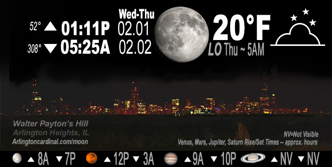
🌔 🌕 🌗 🌑 Waxing Gibbous Moon, sky cover overnight Wed. to Thu. 15% to 4%, winds WSW to SW, 9 to 6 to 14 MPH, G26 to 21 MPH, 1a to 4a, Low 20, 5a to 7a
NWS CHGO | NWS HRLY | /NWSchicago | 🌡
ARLINGTON HEIGHTS WEATHER
▴ forecast7 (Arl. Hts.) | RADAR | WIDE RADAR
IMPORTANT NOTE ON NWS DATA
======================
NIGHT FORECASTS …
NOTE 1: Forecast and information text below may refer to a previous night on Arlingtoncardinal.com, and might not be updated until late afternoon, evening, or overnight. However, Night Sky archives on CARDINAL NEWS Magazine include text forecasts that correspond to the lunar phase graphic above.
NOTE 2: Keep in mind lunar rise and set times don’t always correspond with night weather and early morning lows because on some days during the month the moon is visible in the sky predominantly during the daytime hours.
Overnight Wednesday/Thursday …
Weather Hazards expected …
Elevated Excessive Cold Risk Thursday night.
Limited Ice Jam Flooding Risk.
DISCUSSION…
Wind chills of 15 to 25 below zero are expected Friday morning. The coldest conditions are expected across northern Illinois outside of Chicago.
Saturn went out of view in the night sky Tuesday/Wednesday and returns for viewing on Friday, March 24, 2023.
Hello mobile users! If you encounter mobile “unfriendly” weather page, turn your phone sideways for a better view.
======================
O’HARE FORECAST …
Forecast Beginning Wednesday Night, Feb. 01 , 2023 …
O’HARE FORECAST …
Wednesday Night: Mostly clear, with a low around 18. Southwest wind around 10 mph.
Thursday: Increasing clouds, with a high near 29. West southwest wind 10 to 15 mph becoming northwest in the afternoon. Winds could gust as high as 20 mph.
Thursday Night: Mostly clear, with a low around -1. Wind chill values as low as -19. North northwest wind around 15 mph, with gusts as high as 25 mph.
Friday: Sunny, with a high near 11. Wind chill values as low as -18. North northwest wind 5 to 10 mph becoming west in the afternoon. Winds could gust as high as 15 mph.
Friday Night: Partly cloudy, with a low around 5. South wind 5 to 10 mph increasing to 10 to 15 mph after midnight. Winds could gust as high as 30 mph.
Saturday: Mostly sunny, with a high near 35. Breezy.
Saturday Night: Mostly cloudy, with a low around 31. Breezy.
Sunday: Mostly cloudy, with a high near 38.
Sunday Night: Mostly cloudy, with a low around 24.
Monday: Partly sunny, with a high near 44.
Monday Night: A chance of rain. Cloudy, with a low around 38. Breezy.
Tuesday: A chance of rain. Cloudy, with a high near 45.
Tuesday Night: Mostly cloudy, with a low around 31.
Wednesday: Mostly sunny, with a high near 41.
O’Hare forecast archive and hourly weather observations archive are available HERE on the CARDINAL NEWS Magazine.
Arlingtoncardinal.com/moonphases
Arlingtoncardinal.com/nightsky
NIGHT SKY THIS MONTH …
Check the night sky objects for this month and past months in the playlist from the Space Telescope Science Institute YouTube channel Backyard stargazers get a monthly guide to the northern hemisphere’s skywatching events with “Tonight’s Sky” (Musical track The Far River written by Jonn Serrie, from the album And the Stars Go With You courtesy of New World Music Ltd. Musical track The Far River written by Jonn Serrie, from the album And the Stars Go With You courtesy of New World Music Ltd).
Telephoto lens, ISO 100, f/11, Shutter Speed 1/100 to 1/125 for the Moon.
Get updates from The Cardinal ALL NEWS FEEDS on Facebook. Just ‘LIKE’ the ‘Arlington Cardinal Page (become a fan of our page). The updates cover all posts and sub-category posts from The Cardinal — Arlingtoncardinal.com. You can also limit feeds to specific categories. See all of The Cardinal Facebook fan pages at Arlingtoncardinal.com/about/facebook …
Help fund The Cardinal Arlingtoncardinal.com/sponsor
Telephoto lens, ISO 1600, f/11, Shutter Speed 2.5″ for the skyline. The skyline exposure was toned down, and brightness and contrast was adjusted in Photoshop.
Area Forecast Discussion
National Weather Service Chicago/Romeoville, IL
1119 PM CST Wed Feb 1 2023
.SHORT TERM… Issued at 211 PM CST Wed Feb 1 2023
Through Thursday night…
A broad surface high continues to reside across the Ohio River Valley which has kept our skies cloud-free Wednesday afternoon. The abundant sunshine has helped temperatures to warm into the mid to upper 20s this afternoon with a chance that some areas may see another degree or two of warmth before all is said and done.
An area of cirrus clouds continues to be observed across central and southern Illinois this afternoon with recent satellite trends showing these clouds are starting to drift northwards towards our area. While it looks like the thickest of these clouds would remain across the southern portions of our forecast area, the increasing cloud cover this evening should help to limit the radiational cooling tonight and keep temperatures in the low to mid teens for most areas with some locations under the thicker cloud cover seeing values in the upper teens. The clouds are expected to diminish heading into Thursday morning which will allow for another mostly sunny afternoon which in combination with increasing southwesterly winds should allow temperatures to climb into the upper 20s to mid-30s for most locations, although areas across far northern Illinois may still struggle to get out of the 20s due to the snow pack.
The seasonable temperatures will be brief as an arctic front is expected to swing through northeastern Illinois and northwest Indiana late Thursday afternoon into Friday morning. While the frontal passage continues to look dry, winds will become northwesterly and increase in speed as a tightening pressure gradient (6 to 7 mb increase in 6 hours) develops behind the front. The cold arctic air will send temperatures plummeting into the low single digits to near zero with areas across northern Illinois seeing lows in the negatives. These temperatures in combination with the increasing northwest winds will create wind chills in the -15 to -25 degree range for Friday morning. Wind chills of this magnitude are capable of causing frost bite in less than 30 minutes so be sure to bundle up before heading out Friday morning. If this trend continues a Wind Chill Advisory may be needed with future updates.
Yack/NWS
