
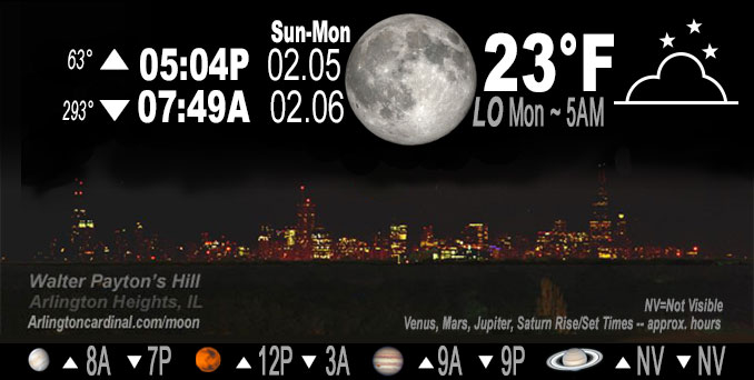
🌕 🌗 🌑 🌓 Full Moon, sky cover overnight Sun. to Mon. 61% to 50% to 58%, winds NW to NNW, 11 to 2 to 5 MPH, G18 to 16 MPH end 6p, Low 23, 5a to 6a
NWS CHGO | NWS HRLY | /NWSchicago | 🌡
ARLINGTON HEIGHTS WEATHER
▴ forecast7 (Arl. Hts.) | RADAR | WIDE RADAR
IMPORTANT NOTE ON NWS DATA
======================
NIGHT FORECASTS …
NOTE 1: Forecast and information text below may refer to a previous night on Arlingtoncardinal.com, and might not be updated until late afternoon, evening, or overnight. However, Night Sky archives on CARDINAL NEWS Magazine include text forecasts that correspond to the lunar phase graphic above.
NOTE 2: Keep in mind lunar rise and set times don’t always correspond with night weather and early morning lows because on some days during the month the moon is visible in the sky predominantly during the daytime hours.
Overnight Sunday/Monday …
No Weather Hazards expected …
DISCUSSION…
Cloud cover is also expected to gradually fill in Sunday evening as the mid-levels saturate ahead of an advancing ridge. As the ridge
moves overhead late this evening winds will become light which looks to set up favorable conditions for fog development late tonight into
Monday morning. However, still cold low of 23°F with cloud cover only has high 61 percent.
Hello mobile users! If you encounter mobile “unfriendly” weather page, turn your phone sideways for a better view.
======================
O’HARE FORECAST …
Forecast Beginning Sunday Night, Feb. 05 , 2023 …
Sunday Night: Mostly cloudy, with a low around 22. Northwest wind 5 to 10 mph becoming light and variable after midnight. Winds could gust as high as 15 mph.
Monday: Partly sunny, with a high near 43. Breezy, with a south southeast wind 5 to 10 mph increasing to 15 to 20 mph in the afternoon. Winds could gust as high as 30 mph.
Monday Night: A 40 percent chance of showers after midnight. Mostly cloudy, with a low around 38. Breezy, with a south southeast wind 20 to 25 mph becoming southwest after midnight. Winds could gust as high as 35 mph.
Tuesday: Mostly cloudy, with a high near 42. Breezy, with a west wind 15 to 25 mph, with gusts as high as 30 mph.
Tuesday Night: Partly cloudy, with a low around 27.
Wednesday: A 20 percent chance of rain after noon. Partly sunny, with a high near 42.
Wednesday Night: Rain likely, mainly after midnight. Cloudy, with a low around 35.
Thursday: Rain likely, mainly before noon. Mostly cloudy, with a high near 45. Breezy.
Thursday Night: A chance of rain before midnight. Mostly cloudy, with a low around 32.
Friday: Mostly cloudy, with a high near 34.
Friday Night: Mostly cloudy, with a low around 21.
Saturday: Partly sunny, with a high near 31.
O’Hare forecast archive and hourly weather observations archive are available HERE on the CARDINAL NEWS Magazine.
Arlingtoncardinal.com/moonphases
Arlingtoncardinal.com/nightsky
NIGHT SKY THIS MONTH …
Check the night sky objects for this month and past months in the playlist from the Space Telescope Science Institute YouTube channel Backyard stargazers get a monthly guide to the northern hemisphere’s skywatching events with “Tonight’s Sky” (Musical track The Far River written by Jonn Serrie, from the album And the Stars Go With You courtesy of New World Music Ltd. Musical track The Far River written by Jonn Serrie, from the album And the Stars Go With You courtesy of New World Music Ltd).
Telephoto lens, ISO 100, f/11, Shutter Speed 1/100 to 1/125 for the Moon.
Get updates from The Cardinal ALL NEWS FEEDS on Facebook. Just ‘LIKE’ the ‘Arlington Cardinal Page (become a fan of our page). The updates cover all posts and sub-category posts from The Cardinal — Arlingtoncardinal.com. You can also limit feeds to specific categories. See all of The Cardinal Facebook fan pages at Arlingtoncardinal.com/about/facebook …
Help fund The Cardinal Arlingtoncardinal.com/sponsor
Telephoto lens, ISO 1600, f/11, Shutter Speed 2.5″ for the skyline. The skyline exposure was toned down, and brightness and contrast was adjusted in Photoshop.
Area Forecast Discussion
National Weather Service Chicago/Romeoville, IL
1056 PM CST Sun Feb 5 2023
.SHORT TERM… Issued at 203 PM CST Sun Feb 5 2023
Through Monday night…
Clouds have struggled to fill in across the area this afternoon likely due to the axis of mid-level dry air that is sitting over the mid Mississippi River Valley. This lack of cloud cover has allowed temperatures to over perform a bit this afternoon with most locations reporting temperatures in the upper 30s and lower 40s, however; a weak frontal boundary is currently pushing across northern Illinois and is expected to move through the rest of the area later this afternoon which will gradually lower temperatures through the evening as northwest winds advect in cooler air.
Cloud cover is also expected to gradually fill in this evening as the mid-levels saturate ahead of an advancing ridge. As the ridge moves overhead late this evening winds will become light which looks to set up favorable conditions for fog development late tonight into Monday morning. Guidance has continued to indicate that the best fog potential would establish across western Illinois near the I-39 corridor where the thicker snow pack should allow for better cooling and increase the odds of the surface reaching saturation. Therefore, I have maintained the going patchy fog mention for our western most tiers of counties, however; I would not be surprised if that mention needed to be extended into our far southern counties where slightly higher dew points may allow for patchy fog to develop there as well.
Any fog that does develop is expected to dissipate Monday morning as winds settle into a southerly direction and begin to increase in speed as the pressure gradient tightens ahead of a quick moving cold front. While the strongest winds look to arrive Monday evening where gusts upwards of 30 mph are expected, the increasing warm advection during the day on Monday will allow temperatures to top out in the mid to upper 30s and lower 40s. In addition to the winds, the front will also bring with it a quick hit of light rain showers late Monday evening into Tuesday morning.
Yack/NWS
