
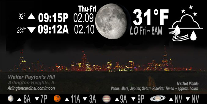
🌖 🌗 🌑 🌓 Waning Gibbous Moon, rain ending 10p Thu., sky cover overnight Thu. to Fri. 100% to 71%, winds NW, 23 to 11 to 13 MPH, G34 to 18 to 21 MPH, Low 31, 8a to 9a
NWS CHGO | NWS HRLY | /NWSchicago | 🌡
ARLINGTON HEIGHTS WEATHER
▴ forecast7 (Arl. Hts.) | RADAR | WIDE RADAR
IMPORTANT NOTE ON NWS DATA
======================
NIGHT FORECASTS …
NOTE: Keep in mind lunar rise and set times don’t always correspond with night weather and early morning lows because on some days during the month the moon is visible in the sky predominantly during the daytime hours.
Overnight Thursday/Friday …
No Weather Hazards Expected
Elevated Non Thunderstorm Wind Risk ending.
Limited Snow Risk ending.
DISCUSSION…
Light rain and/or drizzle mixed with light snow across Chicagoland. This area of light precipitation will exit off to the east by 9:00 p.m. or so, with maybe some spotty flurries or drizzle for a few hours after that. Temperatures solidly above freezing will preclude any snow accumulation Thursday night.
Hello mobile users! If you encounter mobile “unfriendly” weather page, turn your phone sideways for a better view.
======================
O’HARE FORECAST …
Forecast Beginning Thursday Night, Feb. 9 , 2023 …
Thursday Night: A chance of rain and snow showers, mainly before 10pm. Cloudy, with a low around 30. Blustery, with a west northwest wind 20 to 25 mph decreasing to 10 to 15 mph after midnight. Winds could gust as high as 35 mph. Chance of precipitation is 50%.
Friday: Mostly cloudy, then gradually becoming sunny, with a high near 34. Northwest wind 10 to 15 mph, with gusts as high as 20 mph.
Friday Night: Clear, with a low around 24. Northwest wind 5 to 10 mph becoming southwest after midnight. Winds could gust as high as 15 mph.
Saturday: Sunny, with a high near 43. Southwest wind 5 to 15 mph, with gusts as high as 20 mph.
Saturday Night: Clear, with a low around 28. Southwest wind 10 to 15 mph, with gusts as high as 20 mph.
Sunday: Sunny, with a high near 46. Southwest wind around 10 mph, with gusts as high as 15 mph.
Sunday Night: Mostly cloudy, with a low around 31.
Monday: Sunny, with a high near 46.
Monday Night: Mostly clear, with a low around 30.
Tuesday: A chance of rain after noon. Partly sunny, with a high near 49.
Tuesday Night: Rain, mainly before midnight. Cloudy, with a low around 43.
Wednesday: Partly sunny, with a high near 56.
Wednesday Night: A chance of rain. Mostly cloudy, with a low around 39.
O’Hare forecast archive and hourly weather observations archive are available HERE on the CARDINAL NEWS Magazine.
Arlingtoncardinal.com/moonphases
Arlingtoncardinal.com/nightsky
NIGHT SKY THIS MONTH …
Check the night sky objects for this month and past months in the playlist from the Space Telescope Science Institute YouTube channel Backyard stargazers get a monthly guide to the northern hemisphere’s skywatching events with “Tonight’s Sky” (Musical track The Far River written by Jonn Serrie, from the album And the Stars Go With You courtesy of New World Music Ltd. Musical track The Far River written by Jonn Serrie, from the album And the Stars Go With You courtesy of New World Music Ltd).
Telephoto lens, ISO 100, f/11, Shutter Speed 1/100 to 1/125 for the Moon.
Get updates from The Cardinal ALL NEWS FEEDS on Facebook. Just ‘LIKE’ the ‘Arlington Cardinal Page (become a fan of our page). The updates cover all posts and sub-category posts from The Cardinal — Arlingtoncardinal.com. You can also limit feeds to specific categories. See all of The Cardinal Facebook fan pages at Arlingtoncardinal.com/about/facebook …
Help fund The Cardinal Arlingtoncardinal.com/sponsor
Telephoto lens, ISO 1600, f/11, Shutter Speed 2.5″ for the skyline. The skyline exposure was toned down, and brightness and contrast was adjusted in Photoshop.
Area Forecast Discussion
National Weather Service Chicago/Romeoville, IL
1056 PM CST Thu Feb 9 2023
.UPDATE… Issued at 745 PM CST Thu Feb 9 2023
Updated PoPs and weather this evening to account for the last sheared wave over the area, producing prevailing light rain and/or drizzle mixed with light snow across the Chicago metro and points just south. This area of light precipitation will exit off to the east by 9pm or so, with maybe some spotty flurries or drizzle for a few hours after that. Temperatures solidly above freezing will preclude any snow accumulation.
Earlier dry advection has already brought some holes in the stratus deck, so may need to take a look at sky cover trends into Friday morning. The thinking is that even if clearing is a bit quicker, the air and pavement temps are probably far enough freezing now to limit or preclude the risk of black ice development overnight. Breezy northwest winds should help the drying process.
Castro/NWS Chicago
&&
.SHORT TERM… Issued at 258 PM CST Thu Feb 9 2023
Through Friday night…
Strong pressure rises (on the order of 7 mb/3hr) along the southwestern periphery of the surface low, now shifting into southwestern Lower Michigan, continue to drive some strong and gusty west-southwesterly winds across my southern and eastern counties. The strongest winds, with gusts of 45+ mph, have largely been focused south of I-80 and east of I-57. These strong gusty winds to continue late this afternoon, before abating into early this evening. No changes are planned to the 6pm ending time of the wind advisory.
Winds across my northern areas (particularly north of I-88) have turned northerly following the eastward departure of the main surface low. While wind speeds here are not expected to be as strong as points farther south, at least occasional gusts up to around 30 mph are expected through early this evening. Cooler air will filter into northern IL on these northerly winds, and this could allow for some of the lingering moisture falling in the deformation band to mix with some wet snow flakes over northeastern IL early this evening before the precipitation comes to an end. However, no additional snow accumulations are anticipated.
Quieter weather is expected for Friday, with surface high pressure expected to build eastward into the area for Friday night. A drier airmass working into the area should also result in decreasing cloudiness and some sun during the afternoon, though temperatures will likely remain in the 30s during the day. Mainly clear skies and light winds should set the stage for a chilly night across the area Friday night, with readings likely to bottom out in the teens to low 20s into early Saturday morning.
KJB/NWS Chicago
