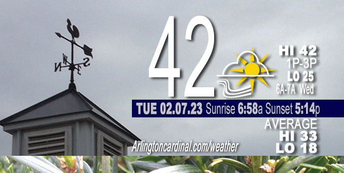
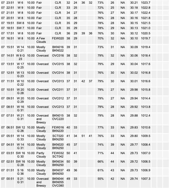
Tuesday Hi 42 (50, 2a to 4a), mostly cloudy to partly sunny, winds WSW to W to WNW, 17 to 20 to 6 MPH, G26 to 30 to 13 MPH end 9p

NWS CHGO | NWS HRLY | /NWSchicago | 🌡
ARLINGTON HEIGHTS WEATHER
▴ forecast7 (Arl. Hts.) | RADAR | WIDE RADAR
⏪ Hrly Data Table | Hrly Future Graph ⏩
IMPORTANT NOTE ON NWS DATA
⏪ Hrly Data Table | Hrly Future Graph ⏩
======================
Tuesday and Tuesday Night …
No Weather Hazards expected …
No weather hazards expected Monday, but gusty winds associated with a daybreak cold front that broke a balmy 50°F overnight will peak to about 30 MPH around 1:00 p.m. to 3:00 p.m. Tuesday. Be prepared for possible locally heavy rain and 50 MPH wind gusts Wednesday night into Thursday. The storm system may bring snow far north Chicagoland and thunder in south Chicagoland.
DISCUSSION…
Gusty winds and a 50°F high for the Tuesday from about 2:00 a.m. to 4:00 a.m. sped up snow cover loss overnight with evaporation and sublimation. A surface cold front is forecast to move east across the Chicagoland forecast area during the daybreak hours. The warm sector ahead of this front was impressive, with temperatures up to 50°F in Chicago when normal daily highs are in the low to mid 30s. A slight recovery of warmth to 42°F is forecast for Tuesday afternoon with sunshine increasing due to gradually decreasing cloud cover after 12:00 p.m.
Daily low temperatures and daily high temperatures are on the way up. A normal temperature stats milestone was yesterday, Monday: Rise of normal daily high from 32°F to 33°F. We’re gaining about 2 minutes of daylight every day in the progression toward vernal equinox, March 20, 2023. We gain three minutes of daylight today, Tuesday, February 7, 2023, and sunrise crosses over the 7:00 a.m. milestone at 6:58 a.m..
======================
O’HARE FORECAST …
Forecast Beginning Tuesday, Feb. 07, 2023
Tuesday: Cloudy, with a high near 42. Breezy, with a west wind 15 to 20 mph, with gusts as high as 30 mph.
Tuesday Night: Partly cloudy, with a low around 25. West wind 5 to 10 mph, with gusts as high as 15 mph.
Wednesday: Partly sunny, with a high near 44. Southwest wind 5 to 10 mph becoming southeast in the afternoon.
Wednesday Night: Rain, mainly after midnight. Low around 36. East wind 5 to 15 mph, with gusts as high as 25 mph. Chance of precipitation is 100%.
Thursday: Rain, mainly before noon. High near 43. Windy, with an east wind 15 to 20 mph becoming west 25 to 30 mph in the morning. Winds could gust as high as 40 mph. Chance of precipitation is 90%.
Thursday Night: A slight chance of rain and snow before 3am, then a slight chance of snow. Mostly cloudy, with a low around 30. Breezy. Chance of precipitation is 20%.
Friday: A 30 percent chance of snow. Mostly cloudy, with a high near 35.
Friday Night: Mostly cloudy, with a low around 21.
Saturday: Sunny, with a high near 36.
Saturday Night: Mostly clear, with a low around 29.
Sunday: Mostly sunny, with a high near 44.
Sunday Night: Mostly cloudy, with a low around 35.
Monday: Mostly cloudy, with a high near 45.


CHICAGOWEATHERSTATION.COM
ChicagoWeatherStation.com I O’Hare Normal Temps/Precip I O’Hare Record Temps, Precip, Snow
LIVE RADAR | STORM TRACKS | UNISYS US IR SAT | UNISYS Midwest IR SAT | UNISYS More IR SAT
WunderMap® with Temperature/Wind Data || Google: Arlington Heights Area Temps | US TEMPS
Full Screen Motion Weather Radar (Wunderground.com)
Midwest Cloud Cover with Arlington Heights Weather Forecast
ChicagoWeatherStation.com I O’Hare Normal Temps/Precip I O’Hare Record Temps, Precip, Snow
SUNLIGHT DATA FOR SECURITY, TRAFFIC SAFETY, AND SPORTS
SunCalc.net data with solar azimuth and trajectory, times for dawn, sunrise, solar noon, sunset, dusk …
NIGHT SKY THIS MONTH …
Backyard stargazers get a monthly guide to the northern hemisphere’s skywatching events with “Tonight’s Sky.” Check the night sky objects for this month and past months in the playlist from the Space Telescope Science Institute YouTube channel (Musical track The Far River written by Jonn Serrie, from the album And the Stars Go With You courtesy of New World Music Ltd).
Get updates from The Cardinal ALL NEWS FEEDS on Facebook. Just ‘LIKE’ the ‘Arlington Cardinal Page (become a fan of our page). The updates cover all posts and sub-category posts from The Cardinal — Arlingtoncardinal.com. You can also limit feeds to specific categories. See all of The Cardinal Facebook fan pages at Arlingtoncardinal.com/about/facebook …
Help fund The Cardinal Arlingtoncardinal.com/sponsor
Area Forecast Discussion
National Weather Service Chicago/Romeoville, IL
526 AM CST Tue Feb 7 2023
.SHORT TERM… Issued at 138 AM CST Tue Feb 7 2023
Through Wednesday…
Key messages:
* Breezy today with falling morning temperatures
* Potential for fog development late tonight/early Wednesday morning over north central and far northern Illinois
A neutrally-tilted upper trough extending from western Ontario through the Corn Belt is quickly racing east early this morning as it is escorted by a 130 kt upper jet over the CONUS midsection. The low-level response is a surface cold front that will move east across the forecast area during the daybreak hours. The warm sector ahead of this front is impressive, with temperatures up to 50F in Chicago (normal daily highs are low to mid 30s). Dew points also are in the upper 30s to lower 40s, which is eroding the remnant snow cover in far northern Illinois. As the front sweeps eastward, westerly winds behind it will drop temperatures about 10 degrees from 5 AM to 10 AM. A slight recovery will occur this afternoon with scattered sunshine. Afternoon highs are still on the plus side of normal with upper 30s to mid 40s.
High pressure of 1025 mb will quickly expand in by late this evening. Light winds and forecast low temperatures 5F+ degrees below forecast evening dew points indicate potential for patchy fog development, especially over any residual snow pack. Some high-resolution guidance hint at that area for reduced visibility. It does not look as favorable of a setup as what occurred Sunday night in north central and far northern Illinois, when areas of dense fog occurred, as the snow pack then was both deeper and colder. Will still continue patchy fog mention in the forecast, and if locations see a dense enough fog there could be frost- coated slick spots underneath it (i.e. freezing fog).
The southern jet stream will start to influence the area gradually more on Wednesday, with a closed upper low starting to approach from the Southern Plains. High clouds will thicken during the day but it will still be warmer than normal. There is a fairly large envelope of temperatures for Wednesday, maybe owing to cloud thickness discrepancies in guidance. For instance the GFS MOS for Chicago has a high of 50F and the NAM only 42F. We lean on the cooler side of the mean at this time with the idea it should be overcast in the afternoon. Some light rain may creep into the far south late day. More on that system in the below discussion.
MTF/NWS Chicago


