
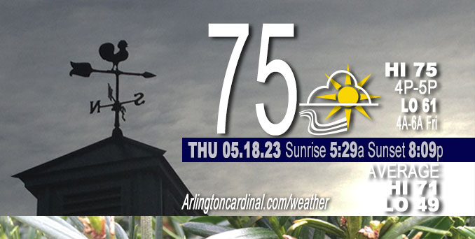
Thursday Hi 77, partly cloudy, winds SE to S, 7 to 9 to 11 MPH, G14 to 13 MPH 8 to 10a and 8p into Friday
NWS CHGO | NWS HRLY | /NWSchicago | 🌡
ARLINGTON HEIGHTS WEATHER
▴ forecast7 (Arl. Hts.) | RADAR | WIDE RADAR
⏪ Hrly Data Table | Hrly Future Graph ⏩
IMPORTANT NOTE ON NWS DATA
⏪ Hrly Data Table | Hrly Future Graph ⏩
Hello mobile users! If you encounter a mobile “unfriendly” weather page, turn your phone sideways for a better view.
======================
Thursday and Thursday Evening …
No Weather Hazards …
Mostly sunny obscured by forest fire smoke from Canada, with a high near 77. South southeast wind around 10 mph, with gusts as high as 15 mph.
DISCUSSION…
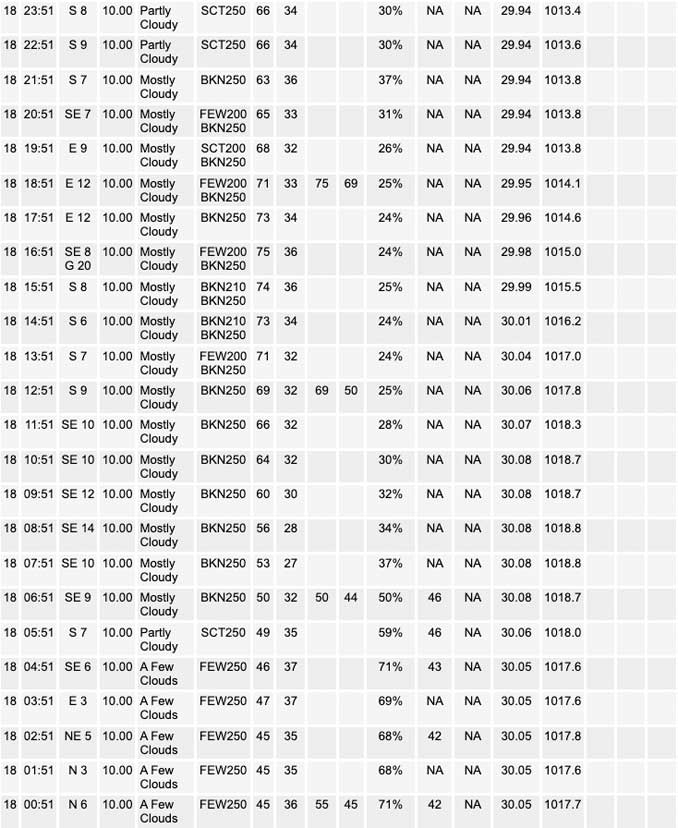
sunny skies today will once again be filtered by the plume of wildfire smoke moving overhead that originates from a plethora of wildfires occurring across parts of Canada. In fact, actually knocked highs back a couple of degrees for today with the smoke sure to shield some of our solar radiation. However, with the pre-frontal warm advection, we`re still looking at middle to upper 70s this afternoon. The southeasterly flow will keep locales west of the lake in the 60s today.
======================
O’HARE FORECAST …
Forecast Beginning Thursday, May 18, 2023
Thursday: Mostly sunny, with a high near 77. South southeast wind around 10 mph, with gusts as high as 15 mph.
Thursday Night: A slight chance of showers and thunderstorms between 1am and 4am, then showers likely and possibly a thunderstorm after 4am. Mostly cloudy, with a low around 61. South southeast wind 10 to 15 mph, with gusts as high as 25 mph. Chance of precipitation is 60%. New rainfall amounts of less than a tenth of an inch, except higher amounts possible in thunderstorms.
Friday: Showers and possibly a thunderstorm before 1pm, then a chance of showers and thunderstorms, mainly between 1pm and 4pm. High near 70. Southwest wind around 10 mph becoming northwest in the afternoon. Winds could gust as high as 15 mph. Chance of precipitation is 90%.
Friday Night: A 10 percent chance of showers before 7pm. Partly cloudy, with a low around 49. North northwest wind around 10 mph, with gusts as high as 20 mph.
Saturday: Sunny, with a high near 68.
Saturday Night: Mostly clear, with a low around 52.
Sunday: Sunny, with a high near 76.
Sunday Night: Mostly clear, with a low around 49.
Monday: Sunny, with a high near 69.
Monday Night: Mostly clear, with a low around 52.
Tuesday: Sunny, with a high near 77.
Tuesday Night: Mostly clear, with a low around 56.
Wednesday: Sunny, with a high near 81.


CHICAGOWEATHERSTATION.COM

ChicagoWeatherStation.com I O’Hare Normal Temps/Precip I O’Hare Record Temps, Precip, Snow
WunderMap® with Temperature/Wind Data || Google: Arlington Heights Area Temps | US TEMPS
Midwest Cloud Cover with Arlington Heights Weather Forecast
ChicagoWeatherStation.com I O’Hare Normal Temps/Precip I O’Hare Record Temps, Precip, Snow
SUNLIGHT DATA FOR SECURITY, TRAFFIC SAFETY, AND SPORTS
SunCalc.net data with solar azimuth and trajectory, times for dawn, sunrise, solar noon, sunset, dusk …
NIGHT SKY THIS MONTH …
Backyard stargazers get a monthly guide to the northern hemisphere’s skywatching events with “Tonight’s Sky.” Check the night sky objects for this month and past months in the playlist from the Space Telescope Science Institute YouTube channel (Musical track The Far River written by Jonn Serrie, from the album And the Stars Go With You courtesy of New World Music Ltd).
Get updates from The Cardinal ALL NEWS FEEDS on Facebook. Just ‘LIKE’ the ‘Arlington Cardinal Page (become a fan of our page). The updates cover all posts and sub-category posts from The Cardinal — Arlingtoncardinal.com. You can also limit feeds to specific categories. See all of The Cardinal Facebook fan pages at Arlingtoncardinal.com/about/facebook …
Help fund The Cardinal Arlingtoncardinal.com/sponsor
/////////////>
Area Forecast Discussion
National Weather Service Chicago/Romeoville, IL
646 AM CDT Thu May 18 2023
.SHORT TERM… Issued at 255 AM CDT Thu May 18 2023
Through Friday…
One more quiet day today will precede a line of showers and possibly a few thunderstorms tomorrow. In the meantime, we remain parked underneath an upper ridge keeping skies (mostly) clear. However, the sunny skies today will once again be filtered by the plume of wildfire smoke moving overhead that originates from a plethora of wildfires occurring across parts of Canada. In fact, actually knocked highs back a couple of degrees for today with the smoke sure to shield some of our solar radiation. However, with the pre-frontal warm advection, we`re still looking at middle to upper 70s this afternoon. The southeasterly flow will keep locales west of the lake in the 60s today.
Clouds will begin building overhead late tonight in anticipation of the front. As low level moisture builds ahead of the boundary, a few isolated pre-frontal showers may try develop with the aid of some modest elevated instability and a subtle, albeit notable, upper jet max that will be building into the area. The primary line is anticipated to arrive in Rockford and vicinity in the middle of the night, perhaps 3AM-ish. Some guidance suggests that the line may be a bit broken at first, before the front can become more organized farther downstream indicated by tightening surface trough. The line will then continue trekking southeastward through the day likely exiting the CWA by the early-mid evening.
Thinking on the thunder potential has changed very little. What modest instability we have at play to begin with will gradually ste Pdown as we move closer to daybreak. This means the lesser thunder chances certainly appear to be from the predawn hours through mid- morning as the front is expected to move across the north and northwest suburbs. Diurnal heating will allow for some additional instability to build through the day slightly increasing the thunder potential roughly near and southeast of I-55 beginning in the late morning. All in all, we`re not expecting any vigorous convection with this line by any means but occasional lightning strikes seem to be the most likely scenario. Temperatures on Friday look to top off in the upper 60s in the northwest to the mid 70s in the southeast CWA where they`ll see at least some diurnal heating before the front arrives.
Doom/NWS Chicago
