
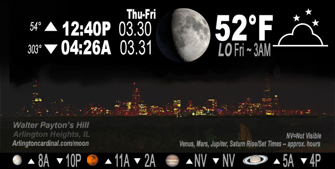
🌔 🌕 🌗 🌑 Waxing Gibbous Moon, sky cover overnight Thu. to Fri. 70% to 90% to 92%, winds SE to SW, 12 to 22 to 18 MPH, G18 to 36 to 31 MPH, Low 52, 3a to 6a
NWS CHGO | NWS HRLY | /NWSchicago | 🌡
ARLINGTON HEIGHTS WEATHER
▴ forecast7 (Arl. Hts.) | RADAR | WIDE RADAR
IMPORTANT NOTE ON NWS DATA
Hello mobile users! If you encounter a mobile “unfriendly” weather page, turn your phone sideways for a better view.
======================
NIGHT FORECASTS …
NOTE: Keep in mind lunar rise and set times don’t always correspond with night weather and early morning lows because on some days during the month the moon is visible in the sky predominantly during the daytime hours.
Overnight Thursday/Friday …
Weather Hazards expected …
Limited Thunderstorm Risk Overnight.
Limited Non Thunderstorm Wind Risk Overnight.
DISCUSSION…
Thunderstorms are expected late tonight. While severe weather is not anticipated, some of the strongest storms may produce small hail. South winds will also gust to 35 mph overnight.
======================
O’HARE FORECAST …
Forecast Beginning Thursday Night, Mar. 30, 2023 …
Thursday Night: A chance of showers and thunderstorms, then showers and possibly a thunderstorm after 3am. Low around 51. Breezy, with a south southwest wind 10 to 15 mph increasing to 15 to 20 mph after midnight. Winds could gust as high as 35 mph. Chance of precipitation is 90%. New rainfall amounts between a tenth and quarter of an inch, except higher amounts possible in thunderstorms.
Friday: Showers and thunderstorms, mainly before 3pm, then showers likely and possibly a thunderstorm after 5pm. Some of the storms could be severe and produce heavy rainfall. High near 64. Breezy, with a south southwest wind around 20 mph, with gusts as high as 35 mph. Chance of precipitation is 80%. New rainfall amounts between a tenth and quarter of an inch, except higher amounts possible in thunderstorms.
Friday Night: Rain showers before midnight, then a slight chance of rain and snow showers after 5am. The rain could be heavy at times. Some thunder is also possible. Low around 36. Windy, with a south wind 20 to 30 mph becoming west southwest after midnight. Winds could gust as high as 45 mph. Chance of precipitation is 100%. Little or no snow accumulation expected.
Saturday: A chance of rain and snow showers, mainly between 8am and 2pm. Mostly cloudy, with a high near 43. Windy, with a west southwest wind 20 to 30 mph becoming north northwest in the afternoon. Winds could gust as high as 40 mph. Chance of precipitation is 50%.
Saturday Night: Mostly clear, with a low around 28. North northwest wind 5 to 15 mph becoming southeast after midnight. Winds could gust as high as 25 mph.
Sunday: Mostly sunny, with a high near 57. Breezy.
Sunday Night: Partly cloudy, with a low around 44. Breezy.
Monday: A chance of rain after 2pm. Mostly sunny, with a high near 62.
Monday Night: Rain likely, mainly after 8pm. Mostly cloudy, with a low around 45.
Tuesday: Rain likely, mainly after 2pm. Mostly cloudy, with a high near 68.
Tuesday Night: Rain and possibly a thunderstorm. Mostly cloudy, with a low around 54. Breezy.
Wednesday: Rain likely. Partly sunny, with a high near 66. Breezy.
Wednesday Night: A chance of rain. Partly cloudy, with a low around 38. Breezy.
Thursday: Mostly sunny, with a high near 51. Breezy.
O’Hare forecast archive and hourly weather observations archive are available HERE on the CARDINAL NEWS Magazine.
Arlingtoncardinal.com/moonphases
Arlingtoncardinal.com/nightsky
NIGHT SKY THIS MONTH …
Check the night sky objects for this month and past months in the playlist from the Space Telescope Science Institute YouTube channel Backyard stargazers get a monthly guide to the northern hemisphere’s skywatching events with “Tonight’s Sky” (Musical track The Far River written by Jonn Serrie, from the album And the Stars Go With You courtesy of New World Music Ltd. Musical track The Far River written by Jonn Serrie, from the album And the Stars Go With You courtesy of New World Music Ltd).
Telephoto lens, ISO 100, f/11, Shutter Speed 1/100 to 1/125 for the Moon.
Get updates from The Cardinal ALL NEWS FEEDS on Facebook. Just ‘LIKE’ the ‘Arlington Cardinal Page (become a fan of our page). The updates cover all posts and sub-category posts from The Cardinal — Arlingtoncardinal.com. You can also limit feeds to specific categories. See all of The Cardinal Facebook fan pages at Arlingtoncardinal.com/about/facebook …
Help fund The Cardinal Arlingtoncardinal.com/sponsor
Telephoto lens, ISO 1600, f/11, Shutter Speed 2.5″ for the skyline. The skyline exposure was toned down, and brightness and contrast was adjusted in Photoshop.
/////////////>
Area Forecast Discussion
National Weather Service Chicago/Romeoville, IL
316 PM CDT Thu Mar 30 2023
.SHORT TERM… Issued at 316 PM CDT Thu Mar 30 2023
Through Friday Evening…
A significant severe weather threat is expected in our area late Friday afternoon into mid-evening, with the potential for significant damaging winds, large hail, and possibly significant tornadoes.
Late tonight/early Friday morning: Widespread convection is expected to develop and lift northeast across the forecast area during the early morning hours intense moisture transport noses into a veering LLJ below steepening mid-level lapse rates. Effective shear will be meager as a vast majority of the bulk shear resides below the inflow base. With that said, the better lapse rates and low freezing levels of 10kft or less will support a small hail risk with perhaps a storm or two capable of marginally severe hail.
Mid-morning Friday into early afternoon: The arrival of the EML will effectively cap the environment during this time, with a notable lull in precip. While continued broad WAA below the EML will foster at least some drizzle or light rain, thunder activity should be minimal.
Mid-late Friday afternoon: As gradual low-level destabilization occurs within increasing mid/upper-level diffluence, guidance has hinted at a subtle 600-700hPa wave shifting NE across the area. Timing is subject to change as the potential wave is still rounding the Four Corners region. However, if the wave does materialize as expected, an initial period of hybrid surface/elevated convection will begin to feed into impressive 8C+/km mid-level lapse rates as effective shear continues to increase. Severe risk will be primarily large hail with any elevated discrete supercells, but the damaging wind risk will increase as surface-based inflow becomes more evident with time. At this point, areas north of I-88 appear to have the highest threat for a midday wave of storms.
Early-mid Friday evening: The overall forecast has not changed considerably with the significant severe storm threat across the entire forecast area during this period. Impressive dynamics driven by a strong jet streak will intersect with a conveyor belt of increasing low-level moisture to rapidly erode remaining surface- based inhibition ahead of an approaching cold front. Discrete supercells are expected to develop west of the Mississippi River by late afternoon and quickly track into the forecast area as upscale convective growth evolves into a QLCS early in the evening. The impressive kinematics support significant wind gusts with any convection through the entire forecast area. Concern for several tornadoes into the area, including a noted risk for significant/long- track tornadoes, continues to increase with the latest forecast guidance. This guidance puts the low-level wind/thermo tornado parameter space into the upper-echelon climatology of values for our area, highlighted by significant 0-1km EHI and 0-3km CAPE that will be realized by discrete supercells. At this point, the highest threat area for tornadoes appears to be near/west of I-39. However, the eastward extent of the highest supercell/tornado risk will be determined by how quickly convection evolves toward a linear mode. The strong linear forcing would normally favor a transition to a QLCS, but deep-layer shear vectors are as close as perpendicular to the front/forcing as one could expect which may support a semi- discrete storm mode even into northeastern Illinois. Given this scenario, tornado probs may need to expanded farther east with at least a broken QLCS and embedded tornado (possibly significant) risk even into the Chicago metro. The severe weather threat will be primarily from 3 PM to 11 PM, but the risk noted in this section is especially after 6 PM.
The fast storm motion pushing 70 mph will clear the entire CWA in less than three hours by 10-11pm. Additional forecast information beyond this period can be found in the long term discussion. Additionally, please continue to follow forecast updates through this event. Have ways to receive warnings from multiple sources.
Kluber/NWS Chicago
