
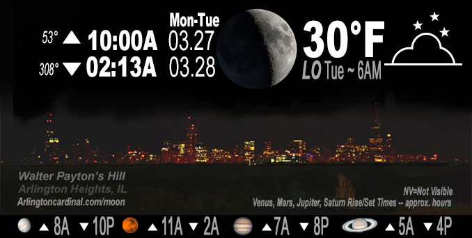
🌒 🌓 🌕 🌗 Waxing Crescent Moon, sky cover overnight Mon. to Tue. 38% to 20% to 70%, winds NE to N to NW, 8 to 0 MPH, Low 30, 6a to 7a
NWS CHGO | NWS HRLY | /NWSchicago | 🌡
ARLINGTON HEIGHTS WEATHER
▴ forecast7 (Arl. Hts.) | RADAR | WIDE RADAR
IMPORTANT NOTE ON NWS DATA
Hello mobile users! If you encounter a mobile “unfriendly” weather page, turn your phone sideways for a better view.
======================
NIGHT FORECASTS …
NOTE: Keep in mind lunar rise and set times don’t always correspond with night weather and early morning lows because on some days during the month the moon is visible in the sky predominantly during the daytime hours.
Overnight Monday/Tuesday …
No Weather Hazards expected …
Partly cloudy overnight, with a low around 30. Calm wind.
DISCUSSION…
The mostly clear skies will persist into the late evening before clouds begin to build overnight. A weak
little wave is forecast to feed in a thin layer of layer of moisture right around 800-750mb that will allow for the added cloud cover. This means we`ll be waking up to mostly cloudy skies on Tuesday.
Skies will clear out initially with temperatures dipping into the upper 20s to lower 30s overnight. High clouds begin to move overhead toward daybreak which may help limit additional cooling. If this area of clouds arrives more slowly the low temperatures will more likely be in the upper 20s.
======================
O’HARE FORECAST …
Forecast Beginning Monday Night, Mar. 27, 2023 …
Monday Night: Partly cloudy, with a low around 30. Calm wind.
Tuesday: Partly sunny, with a high near 50. Light and variable wind becoming west 5 to 10 mph in the morning. Winds could gust as high as 15 mph.
Tuesday Night: Increasing clouds, with a low around 32. West southwest wind 5 to 10 mph, with gusts as high as 15 mph.
Wednesday: Snow likely, mainly before 10am. Cloudy, then gradual clearing during the afternoon, with a high near 39. West southwest wind 10 to 15 mph becoming north northwest in the afternoon. Winds could gust as high as 25 mph. Chance of precipitation is 60%. New snow accumulation of less than a half inch possible.
Wednesday Night: Mostly clear, with a low around 25. North northwest wind around 5 mph becoming calm in the evening. Winds could gust as high as 10 mph.
Thursday: A 20 percent chance of rain after 1pm. Mostly sunny, with a high near 53.
Thursday Night: Rain, mainly after 1am. Low around 46. Breezy. Chance of precipitation is 80%.
Friday: A chance of rain, then rain and possibly a thunderstorm after 1pm. Mostly cloudy, with a high near 65. Breezy.
Friday Night: Rain and possibly a thunderstorm before 1am, then a chance of rain. Mostly cloudy, with a low around 35. Breezy.
Saturday: A chance of rain and snow before 1pm. Partly sunny, with a high near 44. Breezy.
Saturday Night: Mostly clear, with a low around 30.
Sunday: Mostly sunny, with a high near 57.
Sunday Night: Partly cloudy, with a low around 45. Breezy.
Monday: A chance of rain. Partly sunny, with a high near 61.
O’Hare forecast archive and hourly weather observations archive are available HERE on the CARDINAL NEWS Magazine.
Arlingtoncardinal.com/moonphases
Arlingtoncardinal.com/nightsky
NIGHT SKY THIS MONTH …
Check the night sky objects for this month and past months in the playlist from the Space Telescope Science Institute YouTube channel Backyard stargazers get a monthly guide to the northern hemisphere’s skywatching events with “Tonight’s Sky” (Musical track The Far River written by Jonn Serrie, from the album And the Stars Go With You courtesy of New World Music Ltd. Musical track The Far River written by Jonn Serrie, from the album And the Stars Go With You courtesy of New World Music Ltd).
Telephoto lens, ISO 100, f/11, Shutter Speed 1/100 to 1/125 for the Moon.
Get updates from The Cardinal ALL NEWS FEEDS on Facebook. Just ‘LIKE’ the ‘Arlington Cardinal Page (become a fan of our page). The updates cover all posts and sub-category posts from The Cardinal — Arlingtoncardinal.com. You can also limit feeds to specific categories. See all of The Cardinal Facebook fan pages at Arlingtoncardinal.com/about/facebook …
Help fund The Cardinal Arlingtoncardinal.com/sponsor
Telephoto lens, ISO 1600, f/11, Shutter Speed 2.5″ for the skyline. The skyline exposure was toned down, and brightness and contrast was adjusted in Photoshop.
/////////////>
Area Forecast Discussion
National Weather Service Chicago/Romeoville, IL
1221 AM CDT Tue Mar 28 2023
.SHORT TERM… Issued at 245 PM CDT Mon Mar 27 2023
Through Tuesday night…
Temperatures have warmed into the mid to upper 40s across the area this afternoon in spite of cooler air blowing off the southern WI snowpack and Lake Michigan. Areas along the immediate shore and in areas with lingering snow-pack are still in the lower 40, however. Strato-cu has also developed this afternoon, mainly in areas that are not downwind of Lake Michigan where skies have remained clear to mostly clear. Breezy northeast winds will ease after sunset becoming light and variable under the influence of surface high pressure. Skies will clear out initially with temperatures dipping into the upper 20s to lower 30s overnight. High clouds begin to move overhead toward daybreak which may hel Plimit additional cooling. If this area of clouds arrives more slowly the forecast low temperatures may be a bit too warm.
High temperatures on Tuesday will be similar to today for inland areas, though with a westerly wind direction, temperatures will be able to warm closer to the lake with mid 40s to near 50 degrees forecast across the area. A low-amplitude wave will move across central Illinois on Tuesday along which will push mid- level clouds across the area. Cannot rule out a few sprinkles or stray shower Tuesday afternoon with this feature, though think that dry air in the low-levels is pronounced enough to limit this to mainly virga. For now have opted to keep the gridded forecast dry with this update. Our next best chance of precipitation will arrive toward daybreak Wednesday along a cold front. More details on the potential snow showers can be found in the Long Term section below.
Petr/NWS Chicago
