
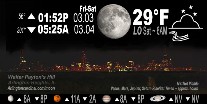
🌔 🌕 🌗 🌑 Waxing Gibbous Moon, sky cover overnight Fri. to Sat. 100% to 58% to 70% to 58%, winds N to NW to W, 20 to 5 MPH, G32 to 16 MPH, 5p to 11p, Low 29, 4a to 6a
NWS CHGO | NWS HRLY | /NWSchicago | 🌡
ARLINGTON HEIGHTS WEATHER
▴ forecast7 (Arl. Hts.) | RADAR | WIDE RADAR
IMPORTANT NOTE ON NWS DATA
======================
NIGHT FORECASTS …
NOTE: Keep in mind lunar rise and set times don’t always correspond with night weather and early morning lows because on some days during the month the moon is visible in the sky predominantly during the daytime hours.
Overnight Friday/Saturday …
No Weather Hazards expected
No hazards Friday night, and Friday’s storm system forecast was highly unpredictable. The storm with deep snow hit primarily east of I-57 and across Indiana. By 7:00 p.m. Friday heavy snow with frequent thunder shifted into Michigan.
DISCUSSION…
An anticipated storm bringing deep snow diverted south and the Winter Storm Watch was expired; and a Winter Weather Advisory is activated Thursday night at 8:38 p.m. By Friday after sunrise, the snowfall accumulation forecast for Arlington Heights and nearby communities was less than 0.5 inch. Finally there was actually zero snow accumulation all day Friday and all the way through Saturday morning.
Jupiter and Venus in conjunction visible after sunset in west sky, except cloud cover will make it difficult or impossible. Venus sets at 8:19 p.m. and Jupiter sets at 8:09 p.m. Friday night. Each night the two planets are visible further apart from each other.
Hello mobile users! If you encounter a mobile “unfriendly” weather page, turn your phone sideways for a better view.
======================
O’HARE FORECAST …
Forecast Beginning Friday Night, Mar. 03, 2023 …
Friday Night: Mostly cloudy, with a low around 29. Blustery, with a west northwest wind 15 to 20 mph decreasing to 5 to 10 mph after midnight. Winds could gust as high as 30 mph.
Saturday: A 20 percent chance of rain after 3pm. Mostly cloudy, with a high near 48. West northwest wind 5 to 10 mph becoming southwest in the afternoon.
Saturday Night: Isolated showers before 9pm. Partly cloudy, with a low around 32. West southwest wind around 5 mph becoming north after midnight. Chance of precipitation is 20%.
Sunday: Mostly cloudy, with a high near 46. North wind 5 to 15 mph becoming east southeast in the afternoon. Winds could gust as high as 20 mph.
Sunday Night: A chance of showers, with thunderstorms also possible after midnight. Mostly cloudy, with a low around 41. Breezy, with an east southeast wind 15 to 20 mph becoming south after midnight. Winds could gust as high as 30 mph. Chance of precipitation is 50%.
Monday: A 40 percent chance of showers and thunderstorms. Mostly cloudy, with a high near 60.
Monday Night: Mostly cloudy, with a low around 34.
Tuesday: Partly sunny, with a high near 41.
Tuesday Night: Mostly cloudy, with a low around 30.
Wednesday: Partly sunny, with a high near 38.
Wednesday Night: Mostly cloudy, with a low around 30.
Thursday: Mostly cloudy, with a high near 36.
Thursday Night: A chance of snow. Mostly cloudy, with a low around 29.
Friday: A chance of snow. Mostly cloudy, with a high near 34.
O’Hare forecast archive and hourly weather observations archive are available HERE on the CARDINAL NEWS Magazine.
Arlingtoncardinal.com/moonphases
Arlingtoncardinal.com/nightsky
NIGHT SKY THIS MONTH …
Check the night sky objects for this month and past months in the playlist from the Space Telescope Science Institute YouTube channel Backyard stargazers get a monthly guide to the northern hemisphere’s skywatching events with “Tonight’s Sky” (Musical track The Far River written by Jonn Serrie, from the album And the Stars Go With You courtesy of New World Music Ltd. Musical track The Far River written by Jonn Serrie, from the album And the Stars Go With You courtesy of New World Music Ltd).
Telephoto lens, ISO 100, f/11, Shutter Speed 1/100 to 1/125 for the Moon.
Get updates from The Cardinal ALL NEWS FEEDS on Facebook. Just ‘LIKE’ the ‘Arlington Cardinal Page (become a fan of our page). The updates cover all posts and sub-category posts from The Cardinal — Arlingtoncardinal.com. You can also limit feeds to specific categories. See all of The Cardinal Facebook fan pages at Arlingtoncardinal.com/about/facebook …
Help fund The Cardinal Arlingtoncardinal.com/sponsor
Telephoto lens, ISO 1600, f/11, Shutter Speed 2.5″ for the skyline. The skyline exposure was toned down, and brightness and contrast was adjusted in Photoshop.
Area Forecast Discussion
National Weather Service Chicago/Romeoville, IL
1058 PM CST Fri Mar 3 2023
.UPDATE… Issued at 648 PM CST Fri Mar 3 2023
The band of impressively heavy snow (with copious amounts of thunder) has now shifted into Michigan with pronounced drying aggressively working into northwestern Indiana. A quick look at webcams shows roadways are now largely wet, thanks to temperatures near or just above freezing. With readings expected to hover right around freezing through the overnight hours, any residual wet spots may attempt to freeze particularly on bridges and overpasses. Otherwise, impacts appear to be largely over. For these reasons, we feel comfortable letting the Winter Storm Warning/Winter Weather Advisories end early (7 PM CT).
Updated products will be sent shortly.
Borchardt
&&
.SHORT TERM… Issued at 355 PM CST Fri Mar 3 2023
Through Saturday night…
Key messages:
* Heavy snow including thundersnow for along/south of I-80, in particularly east of I-57, result in quickly-snow covered roads, including interstates, and dangerous travel in places; consider postponing travel in this area.
* No change to winter headlines; originally considered canceling northern Will County but have opted to keep for light slush and low visibility during the commute.
* High Wind Warning in the far southern CWA has been allowed to expire, with continuing high gusts being concurrent to snow so will be handled with winter headlines
* Isolated rain showers probable Saturday afternoon
Friday Tonight:
Low pressure of 976 mb over southwest Indiana, which is at record low depth for that portion of the country, is providing strong surface winds and forcing for heavy snow along/south of I-80 and east of I-55. Forcing for ascent will continue to be robust immediately north of the negatively-tilted mid to upper level low. This includes a thermally-direct vertical circulation and frontogenesis (f-gen) supporting banded heavy snow. Earlier this afternoon there was a persistent area that used some of its snowfall to cool the column enough for snow to accumulate, while upcoming band(s) east of I-57 will go immediately to accumulating with a cooler boundary layer. There has been an impressive amount of lightning collocated with the snow (thundersnow) that historically are associated with 2+ inch snowfall rates, at least temporarily. Given the potential persistence of bands in northwest Indiana overlapping the commute as well as north winds gusting to 50 mph at times providing further sharp reduction in visibility, we still have concerns for a zone or two of notably dangerous travel this evening in northwest Indiana. Will continue to tactically message that through Graphical NOWcasts and road conditions updates. Snow should taper in the Warning area from west to east between 7 and 9 PM. Total snowfall amounts will be shy of typical Warning criteria for much if not all the Warning, but again rates and timing are the emphasis.
Further northwest, the subsidence at the outside of the system, and likely collocated frontolysis, has held a sharp gradient to the edge of the precipitation (as was a concern). This will re- orient some with the low movement, pushing the leading edge of the rain/snow mix northward in Cook County including downtown Chicago.
Further south along the I-55 corridor (within the Winter Weather Advisory), impacts will continue but be more limited, with secondary roads most susceptible to being snow covered. Occasional thundersnow has been observed in these locations with direct reports of one inch per hour plus snowfall rates. So lingering poor road conditions with additional snow and wind should continue some travel problems through the evening commute.
As the system pulls east, snow will end from west to east and the winds will gradually abate. Clouds should clear as well though there may be some redevelopment of clouds across the northwest hinted at by guidance that may keep temperatures elevated some.
Saturday-Saturday Night:
In true spring fashion, after Friday`s heavy, wet snow for portions of the area, Saturday will quickly moderate back well into the 40s to near/around 50F for areas that didn`t get any snow cover. For the locations with snow cover near and east of I-57, tempered the warm-up to low-mid 40s. Any lingering lower clouds should give way to a mid deck.
A fast moving short-wave paired with a strengthening mid and upper level jet will result in isolated to widely scattered showers and sprinkles spreading eastward from the early to mid afternoon. Some of the CAMs have a bit more robust simulated reflectivity presentation likely owing to a more moist column amidst mid-level lapse rates steepening to around 7.5C/km. With variance of moisture availability, capped measurable PoPs primarily in the slight chance range for now. If better moisture is realized, any heavier showers could produce brief moderate rates.
Clouds are forecast to clear overnight as surface high pressure settles overhead, allowing temps to dip back to the upper 20s to lower 30s, with a few localized mid 20s readings possible in typical cool spots early Sunday morning.
MTF/Castro/NWS Chicago
