
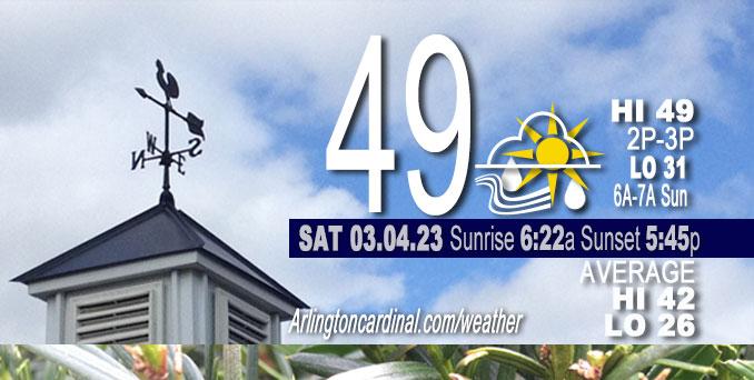
Saturday Hi 49, mostly sunny to mostly cloudy by noon, light rain 3p to 8p, winds W to SW to WSW to W to NW, 5 to 11 to 7 MPH, G16 to 14 MPH, 3p to 5p
NWS CHGO | NWS HRLY | /NWSchicago | 🌡
ARLINGTON HEIGHTS WEATHER
▴ forecast7 (Arl. Hts.) | RADAR | WIDE RADAR
⏪ Hrly Data Table | Hrly Future Graph ⏩
IMPORTANT NOTE ON NWS DATA
⏪ Hrly Data Table | Hrly Future Graph ⏩
======================
Saturday and Saturday Evening …
No Weather Hazards expected …
Clear skies at sunrise, but pockets of fog certainly possible in rural low-lying areas prior to daybreak. Light rain 3:00 p.m. to 8:00 p.m.
DISCUSSION…
The combination of the sun angle increasing, brief shortwave ridging, and some warm air advection at the surface, should cause temperatures to warm into the mid to upper 40s for a good portion of the forecast area, except possibly where snowpack exists (Indiana).
======================
O’HARE FORECAST …
Forecast Beginning Saturday, Mar. 04, 2023
Saturday: Scattered showers after 3pm. Increasing clouds, with a high near 49. West southwest wind 5 to 10 mph, with gusts as high as 15 mph. Chance of precipitation is 50%.
Saturday Night: Scattered showers, mainly before 8pm. Partly cloudy, with a low around 31. West wind 5 to 10 mph becoming north after midnight. Chance of precipitation is 30%.
Sunday: Partly sunny, with a high near 45. North wind 5 to 10 mph becoming east southeast in the afternoon. Winds could gust as high as 15 mph.
Sunday Night: Showers likely, mainly after midnight. Mostly cloudy, with a low around 41. Breezy, with an east wind 10 to 20 mph becoming south after midnight. Winds could gust as high as 25 mph. Chance of precipitation is 60%.
Monday: A 30 percent chance of showers, mainly before noon. Partly sunny, with a high near 61. Breezy, with a south wind 15 to 20 mph becoming west in the afternoon. Winds could gust as high as 35 mph.
Monday Night: Mostly cloudy, with a low around 35. Breezy.
Tuesday: Mostly sunny, with a high near 41. Breezy.
Tuesday Night: Partly cloudy, with a low around 30.
Wednesday: Partly sunny, with a high near 38.
Wednesday Night: Mostly cloudy, with a low around 30.
Thursday: Mostly cloudy, with a high near 37.
Thursday Night: A chance of snow. Mostly cloudy, with a low around 30.
Friday: A chance of snow. Mostly cloudy, with a high near 38.


CHICAGOWEATHERSTATION.COM

ChicagoWeatherStation.com I O’Hare Normal Temps/Precip I O’Hare Record Temps, Precip, Snow
LIVE RADAR | STORM TRACKS | UNISYS US IR SAT | UNISYS Midwest IR SAT | UNISYS More IR SAT
WunderMap® with Temperature/Wind Data || Google: Arlington Heights Area Temps | US TEMPS
Full Screen Motion Weather Radar (Wunderground.com)
Midwest Cloud Cover with Arlington Heights Weather Forecast
ChicagoWeatherStation.com I O’Hare Normal Temps/Precip I O’Hare Record Temps, Precip, Snow
SUNLIGHT DATA FOR SECURITY, TRAFFIC SAFETY, AND SPORTS
SunCalc.net data with solar azimuth and trajectory, times for dawn, sunrise, solar noon, sunset, dusk …
NIGHT SKY THIS MONTH …
Backyard stargazers get a monthly guide to the northern hemisphere’s skywatching events with “Tonight’s Sky.” Check the night sky objects for this month and past months in the playlist from the Space Telescope Science Institute YouTube channel (Musical track The Far River written by Jonn Serrie, from the album And the Stars Go With You courtesy of New World Music Ltd).
Get updates from The Cardinal ALL NEWS FEEDS on Facebook. Just ‘LIKE’ the ‘Arlington Cardinal Page (become a fan of our page). The updates cover all posts and sub-category posts from The Cardinal — Arlingtoncardinal.com. You can also limit feeds to specific categories. See all of The Cardinal Facebook fan pages at Arlingtoncardinal.com/about/facebook …
Help fund The Cardinal Arlingtoncardinal.com/sponsor
Area Forecast Discussion
National Weather Service Chicago/Romeoville, IL
543 AM CST Sat Mar 4 2023
.SHORT TERM… Issued at 220 AM CST Sat Mar 4 2023
Through Sunday…
Key Messages:
* Scattered showers move through this afternoon
* Above normal highs this weekend in the mid-upper 40s (lower 40s in lake adjacent and lingering snow pack areas)
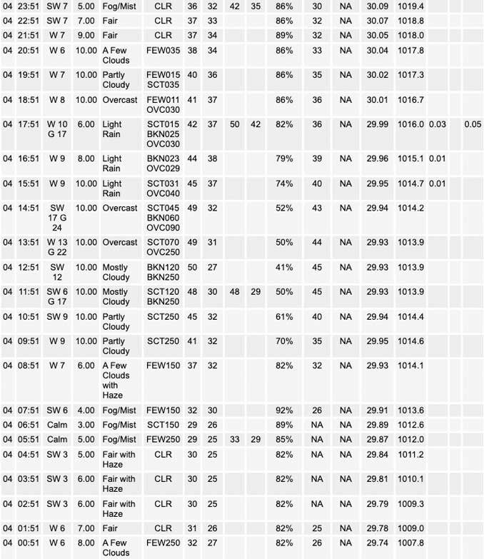
All is quiet early this morning with temperatures in the upper 20s to lower 30s. Other than some lake effect clouds into northwest Indiana skies have cleared out in the wake of the departing weather system which should allow for additional cooling overnight. We are also seeing some haziness out there with small pockets of fog certainly possible in rural low-lying areas prior to daybreak.
The combination of the sun angle increasing, brief shortwave ridging, and some warm air advection at the surface, temperatures should warm into the mid to upper 40s for a good chunk of the forecast area. Will note that areas with a lingering deeper snow- pack may struggle to get into the lower 40s, especially parts of northwest Indiana. This warming combined with the higher March sun angel should help melt most of the remaining snow on the ground.
A low-amplitude shortwave will move through later today bringing scattered showers to the area this afternoon. This feature is currently moving east across Nebraska with two general areas of rain across southern South Dakota and northern Kansas. Model guidance has these features translate east and consolidate over northern Illinois by this afternoon. This also coincides well with an enhancement of the upper jet winds placing our area under the left exit region and hence additional synoptic support for lift. With low and mid-level lapse rates steepening as the wave approaches the character of the rain also looks to trend more showery. There are some questions regarding whether we saturate sufficiently which could keep rainfall rates on the lower-end, though there is enough consistency among the various suite of guidance to continue to message the potential for scattered showers to move through this afternoon into early evening.
Heading into Sunday the upper pattern becomes more zonal with the jet right overhead. Surface high pressure will have moved overhead Saturday night and shifted east of the area and turning winds east to ESE. This combined with increasing cloud cover should hold temperatures in the mid to upper 40s again with lower 40s across far northeast Illinois due to cooling off of Lake Michigan.
Petr/NWS Chicago
