
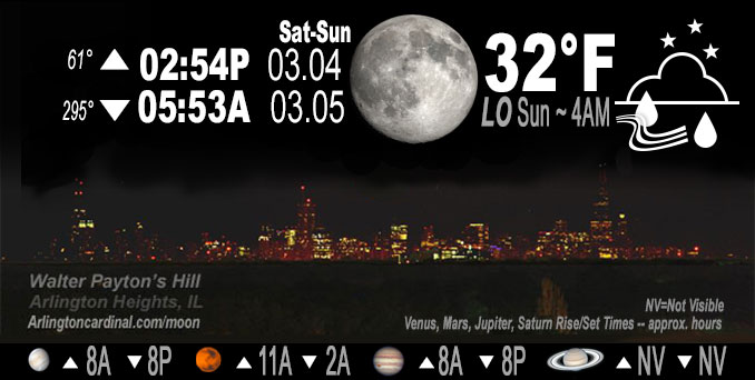
🌔 🌕 🌗 🌑 Waxing Gibbous Moon, rain ends 8p, sky cover overnight Sat. to Sun. 75% to 25% to 72%, winds WSW to W to NW to NNW, 8 to 3 MPH, Low 32, 5a to 6a
NWS CHGO | NWS HRLY | /NWSchicago | 🌡
ARLINGTON HEIGHTS WEATHER
▴ forecast7 (Arl. Hts.) | RADAR | WIDE RADAR
IMPORTANT NOTE ON NWS DATA
======================
NIGHT FORECASTS …
NOTE: Keep in mind lunar rise and set times don’t always correspond with night weather and early morning lows because on some days during the month the moon is visible in the sky predominantly during the daytime hours.
Overnight Saturday/Sunday …
Weather Hazards expected
Limited Fog Risk.
DISCUSSION…
Patches of fog may develop overnight and persist into Sunday morning, primarily for areas near and south of I-88. Locally dense fog is possible closer to and south of the I-80 corridor.
Hello mobile users! If you encounter a mobile “unfriendly” weather page, turn your phone sideways for a better view.
======================
O’HARE FORECAST …
Forecast Beginning Saturday Night, Mar. 04, 2023 …
Saturday Night: Patchy fog before 3am. Otherwise, mostly clear, with a low around 32. West wind around 5 mph, with gusts as high as 10 mph.
Sunday: Increasing clouds, with a high near 44. Light and variable wind becoming east 5 to 10 mph in the morning.
Sunday Night: Scattered showers, then showers likely and possibly a thunderstorm after midnight. Mostly cloudy, with a steady temperature around 41. Southeast wind 10 to 15 mph, with gusts as high as 30 mph. Chance of precipitation is 70%. New rainfall amounts between a tenth and quarter of an inch, except higher amounts possible in thunderstorms.
Monday: A 30 percent chance of rain. Mostly cloudy, with a high near 59. South southeast wind around 15 mph becoming west northwest in the afternoon. Winds could gust as high as 25 mph.
Monday Night: Mostly cloudy, with a low around 35. Breezy, with a northwest wind 15 to 20 mph, with gusts as high as 30 mph.
Tuesday: Partly sunny, with a high near 41. Breezy.
Tuesday Night: Partly cloudy, with a low around 31.
Wednesday: Partly sunny, with a high near 39.
Wednesday Night: Mostly cloudy, with a low around 31.
Thursday: Mostly cloudy, with a high near 38.
Thursday Night: A chance of snow. Mostly cloudy, with a low around 31.
Friday: A chance of snow. Mostly cloudy, with a high near 38. Breezy.
Friday Night: Rain and snow likely. Cloudy, with a low around 32. Breezy.
Saturday: A chance of rain and snow. Mostly cloudy, with a high near 38. Breezy.
O’Hare forecast archive and hourly weather observations archive are available HERE on the CARDINAL NEWS Magazine.
Arlingtoncardinal.com/moonphases
Arlingtoncardinal.com/nightsky
NIGHT SKY THIS MONTH …
Check the night sky objects for this month and past months in the playlist from the Space Telescope Science Institute YouTube channel Backyard stargazers get a monthly guide to the northern hemisphere’s skywatching events with “Tonight’s Sky” (Musical track The Far River written by Jonn Serrie, from the album And the Stars Go With You courtesy of New World Music Ltd. Musical track The Far River written by Jonn Serrie, from the album And the Stars Go With You courtesy of New World Music Ltd).
Telephoto lens, ISO 100, f/11, Shutter Speed 1/100 to 1/125 for the Moon.
Get updates from The Cardinal ALL NEWS FEEDS on Facebook. Just ‘LIKE’ the ‘Arlington Cardinal Page (become a fan of our page). The updates cover all posts and sub-category posts from The Cardinal — Arlingtoncardinal.com. You can also limit feeds to specific categories. See all of The Cardinal Facebook fan pages at Arlingtoncardinal.com/about/facebook …
Help fund The Cardinal Arlingtoncardinal.com/sponsor
Telephoto lens, ISO 1600, f/11, Shutter Speed 2.5″ for the skyline. The skyline exposure was toned down, and brightness and contrast was adjusted in Photoshop.
Area Forecast Discussion
National Weather Service Chicago/Romeoville, IL
1057 PM CST Sat Mar 4 2023
.SHORT TERM… Issued at 259 PM CST Sat Mar 4 2023
Through Sunday night…
Main Forecast Concerns:
* Showers moving across the area through early evening
* Patchy fog possible overnight-early Sunday, especially for areas that still have snow cover
* Showers and a chance for isolated to widely scattered thunderstorms on Sunday night
A vigorous short-wave associated with strong mid and upper level jet streaks is moving across the MS River this afternoon. Despite dry low levels, the strength of the forcing has as expected been enough for an area of rain/showers of primarily light intensity to spread eastward across the region. Observed pockets of 2-5 mile visibility under more robust echoes suggests temporary moderate rain rates and would expect this to continue until the broader area of showers clear the area this evening, particularly north of I-80 where highest PoPs reside. Scattered shower coverage is forecast down to roughly along and north of a PNT to RZL line. Behind the more coherent area of rain, isolated to widely scattered showers on the backside of the short-wave should taper from west to east between about 6pm and 9pm.
Focus overnight then shifts to the potential for patchy fog development. Mid afternoon satellite does show clearing back across Iowa, so would expect skies to trend to partly cloudy to mostly clear as surface high pressure briefly builds overhead. Relatively high dew points over the areas that still have snow cover this afternoon near and east of I-57 and forecast lows farther northwest below crossover temps plus light winds under the surface high support fog development pattern wise. Confidence is on the lower side, as visibility guidance isn`t hitting things too hard. If fog develops, some may become dense in the pre-dawn through early Sunday morning timeframe. Slick spots will also be possible due to temperatures bottoming out in the mid 20s to around 30 where patchy fog is forecast.
The high will shift east on Sunday, shifting winds to northeast and then east and becoming breezy mid-late afternoon for the western half or so of the CWA. Fairly extensive mid and high cloud cover may temper warming potential, though still expect seasonably mild temperatures well into the 40s to lower 50s. Exception will be near the lake due to onshore flow, keeping highs there in the near/around 40F lakeside to low 40s several miles inland.
Fast moving Pacific hybrid type system will track across the Missouri and toward the mid MS Valley on Sunday night. Strong warm advection regime along with good large scale forcing will generate numerous to widespread showers near and north of I-80, with lesser coverage south. Much of the operational and CAM guidance is a bit slower to saturate and support shower development, though 12z ECMWF was faster. Kept PoPs a bit lower early-mid evening as a result, with highest pops late evening and overnight. Cool 500 mb temps of -20 to -25 C will steepen lapse rates enough for modest (100-200 J/kg) MUCAPE and a threat for isolated to widely scattered thunderstorms, also near and north of I-80 primarily, in the late evening and especially overnight.
Castro/NWS Chicago
