
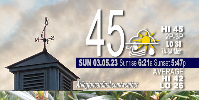
Sunday Hi 45, mostly sunny to partly cloudy by noon, light rain after 6p to 5p Monday, winds NW to NE to E to SE, 3 to 10 to 17 MPH, G18 to 28 MPH, 6p through Monday
NWS CHGO | NWS HRLY | /NWSchicago | 🌡
ARLINGTON HEIGHTS WEATHER
▴ forecast7 (Arl. Hts.) | RADAR | WIDE RADAR
⏪ Hrly Data Table | Hrly Future Graph ⏩
IMPORTANT NOTE ON NWS DATA
⏪ Hrly Data Table | Hrly Future Graph ⏩
======================
Sunday and Sunday Evening …
Weather Hazards expected …
Limited Fog Risk Sunday morning.
Limited Thunderstorm Risk around midnight.
DISCUSSION…
Patches of fog may develop overnight and persist into Sunday morning, primarily for areas near and south of I-88. Locally dense fog is possible closer to and south of the I-80 corridor.
======================
O’HARE FORECAST …
Forecast Beginning Sunday, Mar. 05, 2023
Sunday: Increasing clouds, with a high near 44. Light and variable wind becoming east 5 to 10 mph in the morning.
Sunday Night: Scattered showers, then showers likely and possibly a thunderstorm after midnight. Mostly cloudy, with a steady temperature around 41. Southeast wind 10 to 15 mph, with gusts as high as 30 mph. Chance of precipitation is 70%. New rainfall amounts between a tenth and quarter of an inch, except higher amounts possible in thunderstorms.
Monday: A 30 percent chance of rain. Mostly cloudy, with a high near 59. South southeast wind around 15 mph becoming west northwest in the afternoon. Winds could gust as high as 25 mph.
Monday Night: Mostly cloudy, with a low around 35. Breezy, with a northwest wind 15 to 20 mph, with gusts as high as 30 mph.
Tuesday: Partly sunny, with a high near 41. Breezy.
Tuesday Night: Partly cloudy, with a low around 31.
Wednesday: Partly sunny, with a high near 39.
Wednesday Night: Mostly cloudy, with a low around 31.
Thursday: Mostly cloudy, with a high near 38.
Thursday Night: A chance of snow. Mostly cloudy, with a low around 31.
Friday: A chance of snow. Mostly cloudy, with a high near 38. Breezy.
Friday Night: Rain and snow likely. Cloudy, with a low around 32. Breezy.
Saturday: A chance of rain and snow. Mostly cloudy, with a high near 38. Breezy.


CHICAGOWEATHERSTATION.COM

ChicagoWeatherStation.com I O’Hare Normal Temps/Precip I O’Hare Record Temps, Precip, Snow
LIVE RADAR | STORM TRACKS | UNISYS US IR SAT | UNISYS Midwest IR SAT | UNISYS More IR SAT
WunderMap® with Temperature/Wind Data || Google: Arlington Heights Area Temps | US TEMPS
Full Screen Motion Weather Radar (Wunderground.com)
Midwest Cloud Cover with Arlington Heights Weather Forecast
ChicagoWeatherStation.com I O’Hare Normal Temps/Precip I O’Hare Record Temps, Precip, Snow
SUNLIGHT DATA FOR SECURITY, TRAFFIC SAFETY, AND SPORTS
SunCalc.net data with solar azimuth and trajectory, times for dawn, sunrise, solar noon, sunset, dusk …
NIGHT SKY THIS MONTH …
Backyard stargazers get a monthly guide to the northern hemisphere’s skywatching events with “Tonight’s Sky.” Check the night sky objects for this month and past months in the playlist from the Space Telescope Science Institute YouTube channel (Musical track The Far River written by Jonn Serrie, from the album And the Stars Go With You courtesy of New World Music Ltd).
Get updates from The Cardinal ALL NEWS FEEDS on Facebook. Just ‘LIKE’ the ‘Arlington Cardinal Page (become a fan of our page). The updates cover all posts and sub-category posts from The Cardinal — Arlingtoncardinal.com. You can also limit feeds to specific categories. See all of The Cardinal Facebook fan pages at Arlingtoncardinal.com/about/facebook …
Help fund The Cardinal Arlingtoncardinal.com/sponsor
Area Forecast Discussion
National Weather Service Chicago/Romeoville, IL
322 AM CST Sun Mar 5 2023
.SHORT TERM… Issued at 320 AM CST Sun Mar 5 2023
Through Monday…
Key Messages:
* Areas of fog and freezing fog persist through ~8am CST
* Showers expected tonight into Monday AM with elevated storms possible (best chances N of I-80)
* Warm temps on Monday with highs in the mid 50s to lower 60s
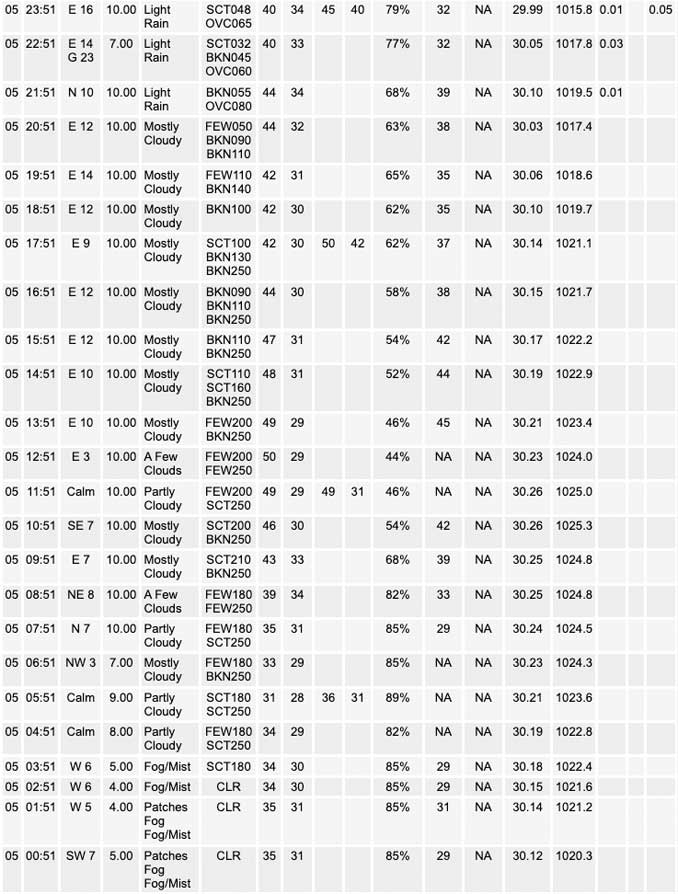
The combination of lingering low-level moisture in the wake of yesterday`s light showers, melting snow pack, and radiational cooling has allowed dense fog and freezing fog to easily expand in coverage early this morning with several observations of 1/4 SM or less ongoing. Thanks to temperatures cooling below freezing in the fog, an icy coating has developed on some elevated surfaces which could result in slick spots, especially on decks, bridges and overpasses. Use caution if traveling early this morning. While there has been some improvement on the northern edge of the fog, conditions have been quickly deteriorating south of I-80 in Illinois over the past couple hours. An area of high clouds is beginning to lift northeast toward the area and surface observations beneath these clouds have seen some visibility improvements so there is a chance that we start to see similar trends into our areas toward daybreak. For now will leave the Dense Fog Advisory expiration of 8am as is.
With the expectation of increasing cloud cover and a flip to east southeast winds by mid-morning as surface high pressure shifts east northeast of the area. Temperatures will be cooler when compared to yesterday for areas immediately west of Lake Michigan, which could struggle to warm out of the lower 40s. Elsewhere temperatures should warm into the mid 40s to near 50 which is still seasonably warm for early March.
The focus in the short term then turns to the potential for showers and thunderstorms to develop and move across parts of the area tonight into Monday morning. Warm advection begins to ramp u Pin advance of an approaching low-amplitude shortwave and weak surface low moving across the Central Plains turning winds southeast and then southwesterly overnight. This should hold overnight low temperatures in the upper 30s to mid 40s! Showers are expected to move into the area sometime this evening as it expands in coverage across southern Wisconsin and northern Illinois. There is a period where lapse rates appear steep enough for sufficient MUCAPE (200-500 J/kg) for isolated elevated thunderstorm development. Models push the initial wave of showers east of the area by daybreak. What happens beyond this period is a bit less certain though some higher-res guidance tries to develo Padditional showers and perhaps even a rogue thunderstorm Monday morning… though some of the 6Z guidance coming in has backed off slightly on this. Nevertheless a few showers/sprinkles could then persist into the afternoon as what is left of the surface low and cold front moves through. Temperatures on Monday still look to be well above normal ahead of the front with highs in the upper 50s north of I-80/88 and lower 60s south.
Petr/NWS Chicago
