
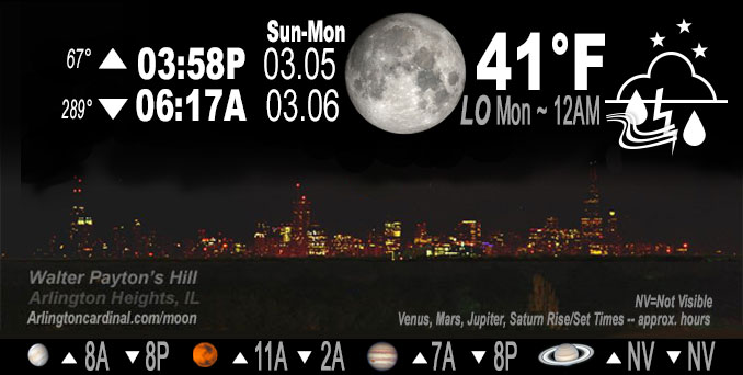
🌔 🌕 🌗 🌑 Waxing Gibbous Moon, thundershowers 9p Sun. to noon Mon., sky cover overnight Sun. to Mon. 90% to 86%, winds E to SE to S, 9 to 16 to 10 MPH, G23 to 16 MPH, Low 41, 12a to 1a
NWS CHGO | NWS HRLY | /NWSchicago | 🌡
ARLINGTON HEIGHTS WEATHER
▴ forecast7 (Arl. Hts.) | RADAR | WIDE RADAR
IMPORTANT NOTE ON NWS DATA
======================
NIGHT FORECASTS …
NOTE: Keep in mind lunar rise and set times don’t always correspond with night weather and early morning lows because on some days during the month the moon is visible in the sky predominantly during the daytime hours.
Overnight Sunday/Monday …
Weather Hazards expected
Limited Thunderstorm Risk.
DISCUSSION…
Widely scattered thunderstorms will develop overnight, primarily along and north of Interstate 80. A few storms may produce dime to nickel size hail and occasional cloud to ground lighting.
Hello mobile users! If you encounter a mobile “unfriendly” weather page, turn your phone sideways for a better view.
======================
O’HARE FORECAST …
Forecast Beginning Sunday Night, Mar. 05, 2023 …
Sunday Night: Scattered showers and thunderstorms, mainly before 4am. Mostly cloudy, with a low around 42. South southeast wind 10 to 15 mph, with gusts as high as 25 mph. Chance of precipitation is 50%.
Monday: Scattered showers and thunderstorms, mainly before 1pm. Mostly cloudy, with a high near 55. South wind 5 to 10 mph becoming north northwest in the afternoon. Chance of precipitation is 40%.
Monday Night: Cloudy, with a low around 35. North northwest wind 10 to 15 mph, with gusts as high as 25 mph.
Tuesday: Cloudy, then gradually becoming mostly sunny, with a high near 41. Northeast wind around 15 mph, with gusts as high as 25 mph.
Tuesday Night: Mostly cloudy, with a low around 31. East wind around 10 mph, with gusts as high as 15 mph.
Wednesday: Mostly cloudy, with a high near 41.
Wednesday Night: Mostly cloudy, with a low around 32.
Thursday: Mostly cloudy, with a high near 39.
Thursday Night: A chance of rain and snow before midnight, then snow likely. Cloudy, with a low around 32.
Friday: Snow likely before noon, then a chance of rain and snow. Cloudy, with a high near 40.
Friday Night: A chance of rain and snow. Mostly cloudy, with a low around 29.
Saturday: Mostly cloudy, with a high near 37.
Saturday Night: Mostly cloudy, with a low around 24.
Sunday: Partly sunny, with a high near 35.
O’Hare forecast archive and hourly weather observations archive are available HERE on the CARDINAL NEWS Magazine.
Arlingtoncardinal.com/moonphases
Arlingtoncardinal.com/nightsky
NIGHT SKY THIS MONTH …
Check the night sky objects for this month and past months in the playlist from the Space Telescope Science Institute YouTube channel Backyard stargazers get a monthly guide to the northern hemisphere’s skywatching events with “Tonight’s Sky” (Musical track The Far River written by Jonn Serrie, from the album And the Stars Go With You courtesy of New World Music Ltd. Musical track The Far River written by Jonn Serrie, from the album And the Stars Go With You courtesy of New World Music Ltd).
Telephoto lens, ISO 100, f/11, Shutter Speed 1/100 to 1/125 for the Moon.
Get updates from The Cardinal ALL NEWS FEEDS on Facebook. Just ‘LIKE’ the ‘Arlington Cardinal Page (become a fan of our page). The updates cover all posts and sub-category posts from The Cardinal — Arlingtoncardinal.com. You can also limit feeds to specific categories. See all of The Cardinal Facebook fan pages at Arlingtoncardinal.com/about/facebook …
Help fund The Cardinal Arlingtoncardinal.com/sponsor
Telephoto lens, ISO 1600, f/11, Shutter Speed 2.5″ for the skyline. The skyline exposure was toned down, and brightness and contrast was adjusted in Photoshop.
Area Forecast Discussion
National Weather Service Chicago/Romeoville, IL
1102 PM CST Sun Mar 5 2023
.UPDATE… Issued at 843 PM CST Sun Mar 5 2023
Evening satellite imagery depicts a somewhat elongated area of implied upper-level vorticity from the Plains to the Great Lakes with an expansive area of low-level WAA across upper Mississippi River Valley. Beneath the upper-level vorticity and atop the low- level WAA is a region of steep mid-level lapse rates sampled near 8 K/km, per the 00Z DVN RAOB. Accordingly, a region of scattered showers and thunderstorms is expanding from central Iowa to northwestern Illinois within the favorable overlap of low- to upper-level lift and steep mid-level lapse rates. As the broad vorticity axis advects eastward tonight, so will the scattered showers and storms setting the stage for a somewhat wet and at times thundery night across our area. The magnitude of instability is meager (e.g. MUCAPE of 300-500 J/kg), though the placement well within the hail growth layer (-10 to -30C) does support a threat for dime to nickel size hail and frequent cloud to ground lightning with any cell overnight (particularly around midnight). In situations like this, you can even sometimes get a sneaky 1″ hail report amongst a plethora of smaller hailstones. Notwithstanding such a threat, the storms should remain tame. Coverage of showers and storms should taper toward daybreak as the region of WAA peels toward the east.
We`ll have to keep an eye on the potential for additional thunderstorms to develop just after daybreak along a narrow axis near I-88, apparently tied to a mid-level perturbation emanating from the Plains atop the surface stable layer. The main threat with any additional storms Monday morning would be cloud to ground lightning and pea size hail. However, at least some threat for gusty winds cannot be ruled out if any storm can take advantage of impressive mid-level shear to dynamically perturb the surface stable layer. Such a threat appears higher in Lower Michigan near I-94.
Borchardt
&&
.SHORT TERM… Issued at 230 PM CST Sun Mar 5 2023
Through Monday night…
Key Messages:
* A 3 to 6 hour period of showers expected within the 9 PM to 3 AM window, mainly north of I-80, with embedded thunder possible
* Mild Monday though stunted from full potential due to clouds
* Breezy tonight and Monday night
A 120 to 150 kt westerly upper jet bisects the CONUS yielding a quasi-zonal pattern as we finish the first weekend of Meteorological Spring. A short wave trough within this jet will pass through the Upper Midwest late tonight into early Monday morning and into the Northern Great Lakes on Monday afternoon. Strong warm air advection (WAA) at and atop the low-level jet layer will steepen mid-level lapse rates as an elevated mixed layer is dragged northeast by this trough. Moisture transport is not robust such as recent deeper systems, though fairly strong isentropic ascent is forecast by mid to late evening for northwest-to-southeast arcs of showers to develop. This is portrayed by numerous CAMs over northeast Iowa, southern Wisconsin, and northern Illinois mainly north of I-80 (especially north of I-88/290). The main question for thunder is whether or not there will be enough saturated depth for elevated parcels to realize MUCAPE of 200 to 600 J/kg forecast across far northern Illinois and points west and north. The dryness in the 500-700 mb layer appears that it probably will hinder what would otherwise be higher thunder coverage given 2 to 5 km lapse rates of 8.5 C/km within WAA. In any taller convection that is able to form, small hail cannot be ruled out given 2 to 5 km shear of 35-40 kt and freezing levels of only 8 kft.
The low-level influence of this system will be a 1007 mb low moving northeastward from the Central Plains that will pass directly over the area in the morning. The pressure gradient ahead of this will support an increasing southeast wind this evening with some gusts to 25 mph by late evening. This will put the brakes on a slight temperature fall early this evening with gradually rising values overnight. As the low passes, the wind will diminish in the morning into early afternoon apart from the far southern CWA. Low-level warm advection to the south of the low path will support a very mild day especially with a warm starting point, with 59F-63F remaining reasonable south of I-80. Along and north of the favored path of the low there is greater uncertainty with how warm given clouds and a less favorable wind profile, as well as 925 mb temperatures falling in the afternoon. Have 50s forecast but could be anywhere from lower to upper and even some spread beyond that. Also, with the light winds under the low and dew points nearing 50F, some fog could develop over the lakeshore.
As for precipitation on Monday, saturation looks like the main issue with even drier mid-level air and capping ~875 mb temperatures. There may be scattered showers to redevelo Pimmediately ahead of the low in the morning into early afternoon. It`s a non-zero thunder chance with these but the better profiles will have passed with the instability/lapse rate gradient tonight.
Cold advection behind the low will overspread the area on northwest to north winds during late day Monday and especially Monday night. This favors breezy conditions as well as likely stratus later in the night. Lake effect profiles get slightly unstable late Monday night and might support cloud depths just enough for some sprinkles near the lake.
MTF/NWS Chicago
