
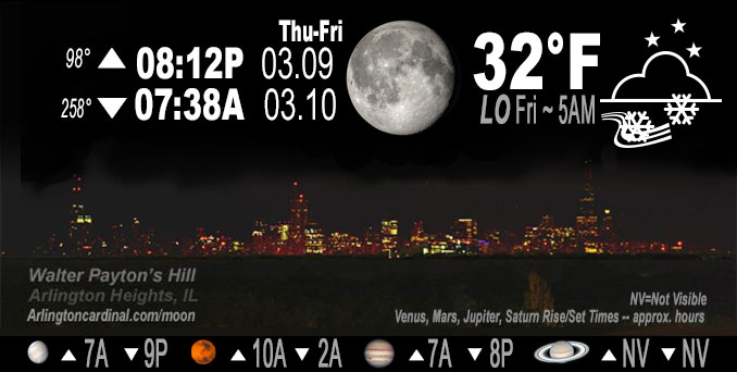
🌖 🌗 🌑 🌓 Waning Gibbous Moon, snow overnight 3.2″ total, sky cover overnight Thu. to Fri. 100%, winds ENE to E to NE, 11 to 10 to 11 MPH, G25 to 15 MPH end 3a, Low 32, 5a to 7a
NWS CHGO | NWS HRLY | /NWSchicago | 🌡
ARLINGTON HEIGHTS WEATHER
▴ forecast7 (Arl. Hts.) | RADAR | WIDE RADAR
IMPORTANT NOTE ON NWS DATA
======================
NIGHT FORECASTS …
NOTE: Keep in mind lunar rise and set times don’t always correspond with night weather and early morning lows because on some days during the month the moon is visible in the sky predominantly during the daytime hours.
Overnight Thursday/Friday …
Weather Hazards expected
Elevated Snow Risk. Winter Weather Advisory
DISCUSSION…
A few to several inches of wet snow will accumulate through tonight north of I-80, with the highest totals near the Wisconsin border. Snow will fall heavily at times this evening near and north of I-88.
Hello mobile users! If you encounter a mobile “unfriendly” weather page, turn your phone sideways for a better view.
======================
O’HARE FORECAST …
Forecast Beginning Thursday Night, Mar. 09, 2023 …
Winter Weather Advisory URGENT – WINTER WEATHER MESSAGE
National Weather Service Chicago IL
312 PM CST Thu Mar 9 2023ILZ104-100515- /O.CON.KLOT.WW.Y.0007.230310T0000Z-230310T1300Z/ Central Cook- Including the cities of Chicago, Cicero, Oak Lawn, Oak Park, and La Grange 312 PM CST Thu Mar 9 2023
…WINTER WEATHER ADVISORY REMAINS IN EFFECT UNTIL 7 AM CST FRIDAY…
* WHAT…Accumulating wet snow expected. Total snow accumulations ranging from 1 to 4 inches, highest well inland.
* WHERE…Central Cook County.
* WHEN…Until 7 AM CST Friday.
* IMPACTS…Untreated roads will become snow covered, particularly between 7 PM and 12 AM when the heaviest snow is expected to fall.
* ADDITIONAL DETAILS…The expected heavy, wet nature of the snow will make shoveling hazardous.
PRECAUTIONARY/PREPAREDNESS ACTIONS…
Slow down and use caution while traveling.
The latest road conditions for Illinois can be obtained on the internet at www.gettingaroundillinois.com.
Thursday Night: Snow. Low around 31. East northeast wind 10 to 15 mph. Chance of precipitation is 100%. Total nighttime snow accumulation of 2 to 4 inches possible.
Friday: Snow likely, possibly mixing with rain after 9am, then gradually ending. Cloudy, with a high near 37. North wind 10 to 15 mph, with gusts as high as 25 mph. Chance of precipitation is 70%. New snow accumulation of less than a half inch possible.
Friday Night: Mostly cloudy, with a low around 30. North wind 5 to 10 mph, with gusts as high as 20 mph.
Saturday: Mostly cloudy, with a high near 36. East wind 5 to 10 mph.
Saturday Night: Snow. Low around 32. East southeast wind around 10 mph, with gusts as high as 15 mph. Chance of precipitation is 90%.
Sunday: A chance of snow before noon, then a chance of rain and snow showers between noon and 3pm, then a chance of snow showers after 3pm. Cloudy, with a high near 38. Chance of precipitation is 40%.
Sunday Night: A 30 percent chance of snow showers, mainly before midnight. Mostly cloudy, with a low around 28.
Monday: Mostly cloudy, with a high near 33.
Monday Night: Partly cloudy, with a low around 20.
Tuesday: Sunny, with a high near 36.
Tuesday Night: Mostly clear, with a low around 24.
Wednesday: Partly sunny, with a high near 46.
Wednesday Night: A chance of showers. Mostly cloudy, with a low around 36.
Thursday: Partly sunny, with a high near 48.
O’Hare forecast archive and hourly weather observations archive are available HERE on the CARDINAL NEWS Magazine.
Arlingtoncardinal.com/moonphases
Arlingtoncardinal.com/nightsky
NIGHT SKY THIS MONTH …
Check the night sky objects for this month and past months in the playlist from the Space Telescope Science Institute YouTube channel Backyard stargazers get a monthly guide to the northern hemisphere’s skywatching events with “Tonight’s Sky” (Musical track The Far River written by Jonn Serrie, from the album And the Stars Go With You courtesy of New World Music Ltd. Musical track The Far River written by Jonn Serrie, from the album And the Stars Go With You courtesy of New World Music Ltd).
Telephoto lens, ISO 100, f/11, Shutter Speed 1/100 to 1/125 for the Moon.
Get updates from The Cardinal ALL NEWS FEEDS on Facebook. Just ‘LIKE’ the ‘Arlington Cardinal Page (become a fan of our page). The updates cover all posts and sub-category posts from The Cardinal — Arlingtoncardinal.com. You can also limit feeds to specific categories. See all of The Cardinal Facebook fan pages at Arlingtoncardinal.com/about/facebook …
Help fund The Cardinal Arlingtoncardinal.com/sponsor
Telephoto lens, ISO 1600, f/11, Shutter Speed 2.5″ for the skyline. The skyline exposure was toned down, and brightness and contrast was adjusted in Photoshop.
Area Forecast Discussion
National Weather Service Chicago/Romeoville, IL
551 PM CST Thu Mar 9 2023
.SHORT TERM… Issued at 252 PM CST Thu Mar 9 2023
Through Friday night…
No changes are planning to the going headlines.
The initial warm air advective surge of precipitation is quickly shifting eastward into northern IL early this afternoon in advance of a quickly approaching vigorous shortwave trough and associated upper level speed max now shifting eastward over the Mid- Missouri Valley. Forced ascent continues to be robust and is largely being driven by rather robust low-to-mid level isentropic upglide (warm air advection) juxtaposed beneath a region of increasingly diffluent upper level flow associated with the exit region of the upper level jet speed max. Given the steep lapse rate environment, heavy precipitation intensities are occurring, with many sites across eastern IA reporting heavy snow with 1/2 to 1/4 mile visibilities and around 1″ per hour rates. Expect this activity to steadily translate eastward into northeastern IL and eventually northwestern IN over the next couple hours this afternoon.
The main forecast idea with this event has not changed much, though the heavier precipitation is arriving a few hours quicker than originally anticipated. We generally still expect the heaviest snow rates (1″ per hour rates) to largely occur north of the I-88/I-290 corridors late this afternoon through mid to late this evening. However, warmer initial temperatures farther to the south over parts of the Chicago metro area and points south and east into northwestern IN will result in the precipitation onsetting as rain for at least a few hours before it begins to mix with snow as far south as the I-80 corridor later this evening. As such, this is likely to result in a sharp snowfall north-to-south snowfall gradient between the I-88 and I-80 corridors.
The heavier snow rates are expected to gradually abate from west to east after midnight as the main larger scale forcing peels off to the east. However, lingering mid-level deformation in the vicinity of the 700 mb low track over far northern IL will likely continue to support periods of lighter snow overnight before it ends early Friday morning. Lake effect parameters continue to look rather poor and largely unsupportive of any meaningful lake enhancement to the precipitation overnight. Total snow accumulations of 4 to 7 inches are still favored near the WI state line, with amounts dropping to around an inch across the I-80 corridor. Farther south of I-80, especially south of the Kankakee River Valley, rain will be the primary precipitation type.
The weather on Friday is likely to remain cloudy, and some lingering flurries could continue into Friday evening. Otherwise, temperatures during the day will remain in the 30s, with the coolest locations likely to be over the snowpack. Temperatures Friday night are then expected to drop into the 20s as a surface ridge of high pressure builds overhead.
KJB/NWS Chicago
