
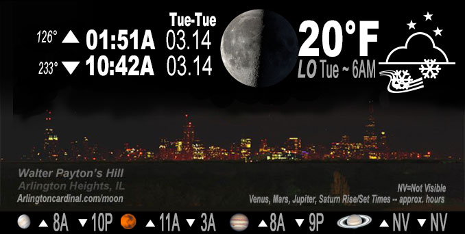
🌗 🌑 🌓 🌕 Last Quarter Moon, snow flurries before midnight, sky cover overnight Mon. to Tue. 96% to 9%, winds N to NNW to NW, 13 to 7 to 9 MPH, G21 to 15 MPH, Low 20, 6a to 7a
NWS CHGO | NWS HRLY | /NWSchicago | 🌡
ARLINGTON HEIGHTS WEATHER
▴ forecast7 (Arl. Hts.) | RADAR | WIDE RADAR
IMPORTANT NOTE ON NWS DATA
Hello mobile users! If you encounter a mobile “unfriendly” weather page, turn your phone sideways for a better view.
======================
NIGHT FORECASTS …
NOTE: Keep in mind lunar rise and set times don’t always correspond with night weather and early morning lows because on some days during the month the moon is visible in the sky predominantly during the daytime hours.
Overnight Monday/Tuesday …
Weather Hazards expected
Limited Snow risk early in Northwest Indiana.
DISCUSSION…
Disorganized multi-band lake effect showers affecting parts of Northwest Indiana at mid- evening.
======================
O’HARE FORECAST …
Forecast Beginning Monday Night, Mar. 13, 2023 …
O’HARE FORECAST …
Monday Night: Scattered flurries with isolated snow showers before 7pm, then scattered flurries between 7pm and 1am. Cloudy, then gradually becoming partly cloudy, with a low around 20. North northwest wind around 10 mph, with gusts as high as 15 mph. Chance of precipitation is 10%.
Tuesday: Sunny, with a high near 36. North northwest wind 5 to 10 mph.
Tuesday Night: Mostly clear, with a low around 21. Calm wind becoming south around 5 mph after midnight.
Wednesday: Mostly sunny, with a high near 49. South wind 5 to 15 mph, with gusts as high as 25 mph.
Wednesday Night: A 20 percent chance of rain after 1am. Mostly cloudy, with a low around 41. Breezy.
Thursday: Rain, mainly after 1pm. High near 50. Chance of precipitation is 90%.
Thursday Night: Rain. Cloudy, with a low around 38.
Friday: Rain likely before 1pm, then a chance of rain and snow. Mostly cloudy, with a high near 47. Breezy.
Friday Night: A chance of snow. Mostly cloudy, with a low around 24. Breezy.
Saturday: Mostly cloudy, with a high near 31. Breezy.
Saturday Night: Mostly cloudy, with a low around 23.
Sunday: Mostly sunny, with a high near 37.
Sunday Night: Partly cloudy, with a low around 26.
Monday: Mostly sunny, with a high near 44.
O’Hare forecast archive and hourly weather observations archive are available HERE on the CARDINAL NEWS Magazine.
Arlingtoncardinal.com/moonphases
Arlingtoncardinal.com/nightsky
NIGHT SKY THIS MONTH …
Check the night sky objects for this month and past months in the playlist from the Space Telescope Science Institute YouTube channel Backyard stargazers get a monthly guide to the northern hemisphere’s skywatching events with “Tonight’s Sky” (Musical track The Far River written by Jonn Serrie, from the album And the Stars Go With You courtesy of New World Music Ltd. Musical track The Far River written by Jonn Serrie, from the album And the Stars Go With You courtesy of New World Music Ltd).
Telephoto lens, ISO 100, f/11, Shutter Speed 1/100 to 1/125 for the Moon.
Get updates from The Cardinal ALL NEWS FEEDS on Facebook. Just ‘LIKE’ the ‘Arlington Cardinal Page (become a fan of our page). The updates cover all posts and sub-category posts from The Cardinal — Arlingtoncardinal.com. You can also limit feeds to specific categories. See all of The Cardinal Facebook fan pages at Arlingtoncardinal.com/about/facebook …
Help fund The Cardinal Arlingtoncardinal.com/sponsor
Telephoto lens, ISO 1600, f/11, Shutter Speed 2.5″ for the skyline. The skyline exposure was toned down, and brightness and contrast was adjusted in Photoshop.
Area Forecast Discussion
National Weather Service Chicago/Romeoville, IL
1139 PM CDT Mon Mar 13 2023
.UPDATE… Issued at 958 PM CDT Mon Mar 13 2023
Going forecast is in generally good shape this evening, though did make some tweaks to lower QPF/snow amounts slightly in northwest IN. Regional radar mosaic depicts somewhat disorganized multi-band lake effect showers affecting parts of northwest IN at mid- evening. Web/plow cams across northern Lake and Porter counties show little/no accumulation or significant impacts to visibility at this time. Slightly better convergent focus appears to be located further east into southwest MI/north central IN, though CAM guidance does suggest this may slip back toward the Porter/LaPorte county line later tonight. RAP soundings depict equilibrium heights around 7500 ft will persist through midnight, then gradually decrease as deep subsidence in the wake of the departing upper trough leads to lowering inversion heights after midnight. With generally no accumulation occurring so far, did trim QPF/snow amounts across northwest IN, with amounts of a trace to around a half inch expected.
Elsewhere, flurries and light snow showers continue at this hour, but these will also diminish as subsidence strengthens and begins to erode from the north. Otherwise, temp and wind trends look good through the rest of the night.
Ratzer
&&
.SHORT TERM… Issued at 300 PM CDT Mon Mar 13 2023
Through Tuesday night…
Blustery northerly winds will continue today in the wake if this mornings cold frontal passage, but speeds are expected to abate into this evening. The presence of steep low-level lapse rates in this cold air advective regime will also continue to support a deck of strato cu with intermittent periods of snow showers and flurries into early this evening. However, the most pronounced snow showers are expected to be confined to far eastern IL and especially into northwestern IN, where improving lake effect parameters this afternoon and evening will support more organized snow showers.
Far northwestern IN looks to be under streaming lake effect snow showers tonight, with the primary focus likely shifting over Porter county IN later this evening and overnight. Lake induced equilibrium levels peaking near 8,000 ft tonight should be sufficiently high enough to bisect through the DGZ as 850 to surface water temperature differences peak around 15C. Accordingly, snow rates with these streaming snow showers could become of moderate intensity at times tonight. While this may end up resulting in some localized travel impacts across parts of Porter county IN tonight due to accumulating snow, it appears the residence time of the snow showers will be somewhat limited as the better focus gradually sets up east of the area late tonight. For this reason, it appears some localized amounts of 1 to perhaps as high as 3″ could occur tonight into parts of Porter county IN. We will continue to message this in our weather story products.
Outside of the lake effect snow for parts of northwestern IN there remains some uncertainty as to how quickly things will clear our tonight as low-level moisture potentially remains trapped under a subsidence inversion aloft for several more hours. While satellite trends continue to show holes within the upstream strato cu deck streaming southward across WI, this deck remains rather expansive. For this reason, we may be slow to see a total clearing of the cloud cover tonight. This could ultimately have some impact on how cold temperatures get overnight. However, with the potential to see more holes develop through the night I did not want to make any big changes to temperatures at this point. We are therefore still expecting lows to fall into the teens over far northern IL and into the low to mid 20s south.
A surface ridge of high pressure will shift across the area Tuesday afternoon. Light winds and mainly sunny skies should result under this high Tuesday afternoon, though temperatures will remain chilly with highs remaining in the 30s. Thereafter, another chilly night is likely Tuesday night, but conditions will begin to warm with a return to southerly flow for Wednesday.
KJB/NWS Chicago
