
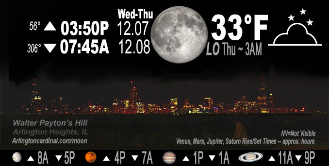
🌕 🌗 🌑 🌓 Full Moon, sky cover overnight Wed. to Thu. 67% to 79%, winds NNW to NNE to NE, 7 to 6 MPH, Low 33, 3a to 5a
NWS CHGO | NWS HRLY | /NWSchicago | 🌡
ARLINGTON HEIGHTS WEATHER
▴ forecast7 (Arl. Hts.) | RADAR | WIDE RADAR
IMPORTANT NOTE ON NWS DATA
======================
Overnight Wednesday/Thursday …
No Weather Hazards expected…
DISCUSSION…
Low temperature forecast of 33°F for early Thursday morning is significantly higher than the normal low temperature of 23°F for December 8.
Fog is not indicated in the forecast, but can’t be ruled out this time of year.
Cloud cover tonight with the stratus building south from Wisconsin and high cloudiness south, plus likely some developing fog/low stratus, areas of dense fog to western and southern Chicagoland.
Quiet weather for Wednesday night with no precipitation and very little wind, but rain is possible beginning as early as Thursday around 7:00 p.m. to 9:00 p.m. A light snow mix is possible beginning around 12:00 a.m. Friday, but only about 0.1 inch accumulation from about 6:00 a.m. to noon on Friday is in the forecast.
Note: Temperatures made it down to 31°F but were forecast only down to 34°F
Hello mobile users! If you encounter mobile “unfriendly” weather page, turn your phone sideways for a better view.
======================
O’HARE FORECAST …
Forecast Beginning Wednesday Night, Dec. 7, 2022
Wednesday Night: Mostly cloudy, with a low around 34. North northeast wind around 5 mph.
Thursday: A 30 percent chance of rain after noon. Cloudy, with a high near 44. East northeast wind 5 to 10 mph, with gusts as high as 20 mph.
Thursday Night: Rain, mainly after midnight. Low around 37. Chance of precipitation is 80%.
Friday: Rain, mainly before noon. High near 42. Chance of precipitation is 80%.
Friday Night: Mostly cloudy, with a low around 34.
Saturday: Mostly cloudy, with a high near 41.
Saturday Night: Mostly cloudy, with a low around 31.
Sunday: Mostly cloudy, with a high near 41.
Sunday Night: A chance of rain and snow. Mostly cloudy, with a low around 34.
Monday: A chance of rain and snow. Mostly cloudy, with a high near 43.
O’Hare forecast archive and hourly weather observations archive are available HERE on the CARDINAL NEWS Magazine.
Arlingtoncardinal.com/moonphases
Arlingtoncardinal.com/nightsky
NIGHT SKY THIS MONTH …
Check the night sky objects for this month and past months in the playlist from the Space Telescope Science Institute YouTube channel Backyard stargazers get a monthly guide to the northern hemisphere’s skywatching events with “Tonight’s Sky” (Musical track The Far River written by Jonn Serrie, from the album And the Stars Go With You courtesy of New World Music Ltd. Musical track The Far River written by Jonn Serrie, from the album And the Stars Go With You courtesy of New World Music Ltd).
Telephoto lens, ISO 100, f/11, Shutter Speed 1/100 to 1/125 for the Moon.
Get updates from The Cardinal ALL NEWS FEEDS on Facebook. Just ‘LIKE’ the ‘Arlington Cardinal Page (become a fan of our page). The updates cover all posts and sub-category posts from The Cardinal — Arlingtoncardinal.com. You can also limit feeds to specific categories. See all of The Cardinal Facebook fan pages at Arlingtoncardinal.com/about/facebook …
Help fund The Cardinal Arlingtoncardinal.com/sponsor
Telephoto lens, ISO 1600, f/11, Shutter Speed 2.5″ for the skyline. The skyline exposure was toned down, and brightness and contrast was adjusted in Photoshop.
Area Forecast Discussion
National Weather Service Chicago/Romeoville, IL
833 PM CST Wed Dec 7 2022
.UPDATE… Issued at 833 PM CST Wed Dec 7 2022
Have added some areas of dense fog to western and southern CWA tonight. Despite extensive mid-high level cloudiness, T/Td depressions are at or just above 0F, so even some muted radiational cooling through the high cloudiness could allow fog to become locally dense. Already seeing some AWOS bounce down below 2SM, so with a long night ahead, seemed prudent to introduce some fog into the forecast. Stratus building south from WI should limit fog potential, so confined fog to southern CWA.
Otherwise, beefed up cloud cover tonight with the stratus building south from WI and the high cloudiness south, plus likely some developing fog/low stratus. Between lingering stratus and mid deck ahead of the next wave arriving tomorrow afternoon, seems like any sun/clearing tomorrow will be the exception.
Updated forecast and grids are out.
– Izzi
&&
.SHORT TERM… Issued at 316 PM CST Wed Dec 7 2022
Through Thursday…
Some areas (mainly west and southwest of Chicago) have managed to see breaks in the low stratus early this afternoon! Temperatures have also managed to warm into the lower to mid 40s even in areas that have been socked in low stratus all day. The weather remains quiet the rest of the afternoon with light west to at times variable winds. This evening and overnight winds will flop to north and then northeasterly as surface high pressure shifts east along the US- Canadian border and over Lake Superior. Temperatures tonight dip into the lower to mid 30s in most areas, with upper 20s to around 30 possible across northwest Illinois and near the IL/WI stateline. Think that the fog risk is much lower tonight than last night with slightly higher winds and lower dewpoints sloshing into the area. That being said, cannot rule out a highly localized patches of fog in especially fog-prone areas outside of the Chicago metro.
Heading into Thursday our next weather system will be approaching from the west. There continues to be a slowing trend with the arrival of the bulk of the precipitation with this system and is discussed in more detail in the long term section below. Out ahead of the surface low warm advective showers may extend eastward across central Illinois into Indiana. It is possible this activity lifts far enough north to reach portions of the area during the afternoon so have maintained a chance of light rain mainly south of the Kankakee River Valley. Think that the Chicago metro should stay dry through the daytime hours.
Petr/NWS Chicago
