
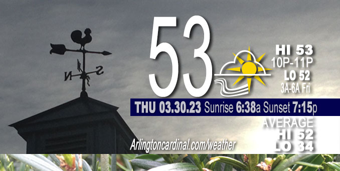
Thursday Hi 53, mostly cloudy to partly sunny, winds SE to E, 7 to 12 to 10 MPH, G21 to 24 to 33 MPH, through Friday
NWS CHGO | NWS HRLY | /NWSchicago | 🌡
ARLINGTON HEIGHTS WEATHER
▴ forecast7 (Arl. Hts.) | RADAR | WIDE RADAR
⏪ Hrly Data Table | Hrly Future Graph ⏩
IMPORTANT NOTE ON NWS DATA
⏪ Hrly Data Table | Hrly Future Graph ⏩
Hello mobile users! If you encounter a mobile “unfriendly” weather page, turn your phone sideways for a better view.
======================
Thursday and Thursday Evening …
No Weather Hazards expected …
Partly sunny Thursday, with a high near 53 late night; storms coming Friday.
DISCUSSION…
An intense mid and upper level trough over California early this morning is forecast to eject eastward across the Rockies tonight, then deepen as it becomes increasingly negatively tilted while shifting towards the Mid-Mississippi Valley on Friday.
======================
O’HARE FORECAST …
Forecast Beginning Thursday, Mar. 30, 2023
Thursday: Partly sunny, with a high near 53 late night. Southeast wind around 9 mph.
Thursday Night: A chance of showers and thunderstorms, then showers and possibly a thunderstorm after 3am. Low around 51. Breezy, with a south southwest wind 10 to 15 mph increasing to 15 to 20 mph after midnight. Winds could gust as high as 35 mph. Chance of precipitation is 90%. New rainfall amounts between a tenth and quarter of an inch, except higher amounts possible in thunderstorms.
Friday: Showers and thunderstorms, mainly before 3pm, then showers likely and possibly a thunderstorm after 5pm. Some of the storms could be severe and produce heavy rainfall. High near 64. Breezy, with a south southwest wind around 20 mph, with gusts as high as 35 mph. Chance of precipitation is 80%. New rainfall amounts between a tenth and quarter of an inch, except higher amounts possible in thunderstorms.
Friday Night: Rain showers before midnight, then a slight chance of rain and snow showers after 5am. The rain could be heavy at times. Some thunder is also possible. Low around 36. Windy, with a south wind 20 to 30 mph becoming west southwest after midnight. Winds could gust as high as 45 mph. Chance of precipitation is 100%. Little or no snow accumulation expected.
Saturday: A chance of rain and snow showers, mainly between 8am and 2pm. Mostly cloudy, with a high near 43. Windy, with a west southwest wind 20 to 30 mph becoming north northwest in the afternoon. Winds could gust as high as 40 mph. Chance of precipitation is 50%.
Saturday Night: Mostly clear, with a low around 28. North northwest wind 5 to 15 mph becoming southeast after midnight. Winds could gust as high as 25 mph.
Sunday: Mostly sunny, with a high near 57. Breezy.
Sunday Night: Partly cloudy, with a low around 44. Breezy.
Monday: A chance of rain after 2pm. Mostly sunny, with a high near 62.
Monday Night: Rain likely, mainly after 8pm. Mostly cloudy, with a low around 45.
Tuesday: Rain likely, mainly after 2pm. Mostly cloudy, with a high near 68.
Tuesday Night: Rain and possibly a thunderstorm. Mostly cloudy, with a low around 54. Breezy.
Wednesday: Rain likely. Partly sunny, with a high near 66. Breezy.
Wednesday Night: A chance of rain. Partly cloudy, with a low around 38. Breezy.
Thursday: Mostly sunny, with a high near 51. Breezy.

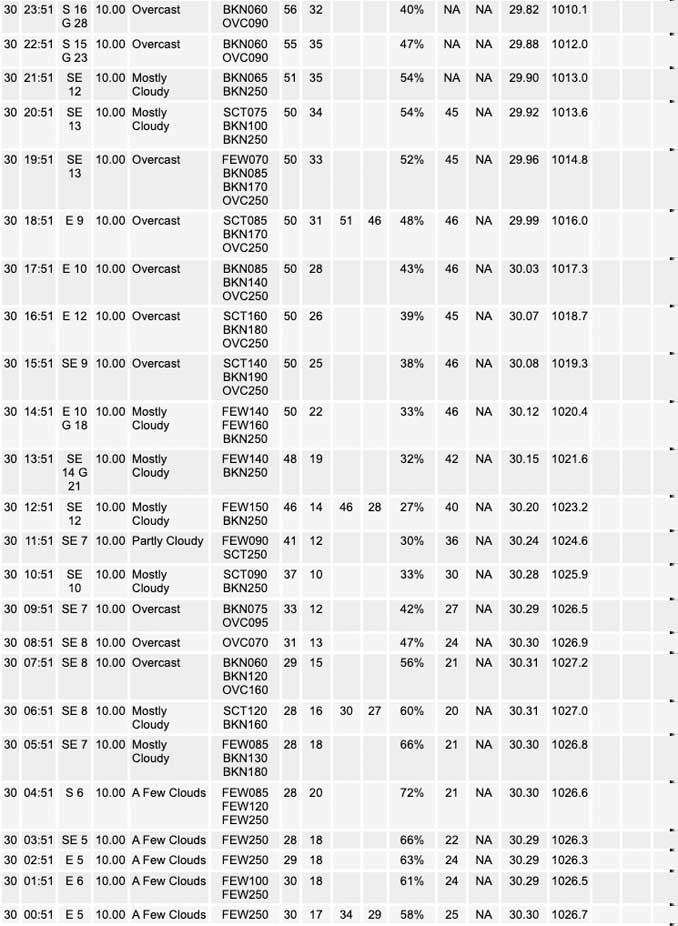
If you don’t see data below this blue header, you are viewing today’s current weather while the full day’s data is not complete; O’Hare forecast archive and hourly weather observations archive are available HERE on the CARDINAL NEWS Magazine …


CHICAGOWEATHERSTATION.COM

ChicagoWeatherStation.com I O’Hare Normal Temps/Precip I O’Hare Record Temps, Precip, Snow
LIVE RADAR | STORM TRACKS | UNISYS US IR SAT | UNISYS Midwest IR SAT | UNISYS More IR SAT
WunderMap® with Temperature/Wind Data || Google: Arlington Heights Area Temps | US TEMPS
Full Screen Motion Weather Radar (Wunderground.com)
Midwest Cloud Cover with Arlington Heights Weather Forecast
ChicagoWeatherStation.com I O’Hare Normal Temps/Precip I O’Hare Record Temps, Precip, Snow
SUNLIGHT DATA FOR SECURITY, TRAFFIC SAFETY, AND SPORTS
SunCalc.net data with solar azimuth and trajectory, times for dawn, sunrise, solar noon, sunset, dusk …
NIGHT SKY THIS MONTH …
Backyard stargazers get a monthly guide to the northern hemisphere’s skywatching events with “Tonight’s Sky.” Check the night sky objects for this month and past months in the playlist from the Space Telescope Science Institute YouTube channel (Musical track The Far River written by Jonn Serrie, from the album And the Stars Go With You courtesy of New World Music Ltd).
Get updates from The Cardinal ALL NEWS FEEDS on Facebook. Just ‘LIKE’ the ‘Arlington Cardinal Page (become a fan of our page). The updates cover all posts and sub-category posts from The Cardinal — Arlingtoncardinal.com. You can also limit feeds to specific categories. See all of The Cardinal Facebook fan pages at Arlingtoncardinal.com/about/facebook …
Help fund The Cardinal Arlingtoncardinal.com/sponsor
/////////////>
Area Forecast Discussion
National Weather Service Chicago/Romeoville, IL
637 AM CDT Thu Mar 30 2023
.SHORT TERM… Issued at 347 AM CDT Thu Mar 30 2023
Through Saturday morning…
A very strong and dynamic storm system is expected to impact the region tonight through Saturday morning. The primary key messages with this system are:
* Initial period of thunderstorms likely tonight. Severe potential is low with these storms, but some storms could produce small hail.
* Increasing threat for all hazards severe thunderstorms, particularly mid to late Friday afternoon through into the evening (roughly 3pm through 11pm). Concern also increasing for more significant severe weather producing storms capable of producing tornados and damaging wind gusts in excess of 75.
* Period of strong (50+ mph non-thunderstorm) westerly winds likely behind a cold front late Friday night into Saturday morning.
An intense mid and upper level trough over California early this morning is forecast to eject eastward across the Rockies tonight, then deepen as it becomes increasingly negatively tilted while shifting towards the Mid-Mississippi Valley on Friday. This system will induce impressively strong deep layer southwesterly flow across a good chuck of the central CONUS Friday afternoon and evening as an associated surface cyclone deepens to a sub 990 mb central pressure over northern IA. Conceptually, this supports an all hazards severe weather threat centered over much of Mississippi Valley Friday afternoon and evening.
Lee cyclogenesis onsetting across the central High Plains today will sharpen a warm front across northern IL this afternoon. Conditions will warm well into the 50s south of this warm front today. However, with the front likely remaining hung up along the northeastern IL lakefront today, an onshore southeasterly wind will likely keep the lakeshore areas of far northeastern IL in the low to mid 40s today. This warm front should shift north into WI into tonight, and as it does so temperatures in far northeastern IL will warm into the 50s overnight, while inland areas remain nearly steady in the 50s.
Aside from the possibility for a few showers this afternoon near the WI state line, most areas remain dry today. This changes tonight, however, as a strengthening low-level jet kicks up the theta-E advection into the region beneath a region of steepening mid-level lapse rates along the northeastern periphery of an EML plume building over the Midwest. This is expected to support the development of elevated thunderstorms overhead after midnight tonight. While these storms are not likely to become severe, hail could become a threat with any of the stronger updrafts that take full advantage of the steep lapse rates aloft.
It appears the shower and thunderstorm threat may briefly break for a period Friday morning as the EML plume continues to build eastward into the area, leading to increased capping. Low clouds and drizzle may persist in the morning, however. Our main concern for severe thunderstorms comes potentially as early as the early afternoon hours of Friday, but will be most likely during the mid to late afternoon (after 3 PM) through the mid evening hours (10 or 11 PM). Some HIRES convective allowing models are attempting to resolve a lead wave of convection that could develop into parts of northern IL after 1 PM on Friday in advance of the main approaching front and triple point. It remains a bit unclear at this time if this potential lead wave of storms would be able to break the cap and support surface based development. Nevertheless, if any elevated storms do develop with this lead wave, the kinematic environment would support super cells capable of producing very large hail.
While confidence on the lead wave of storms remains low, expectations continue to focus on the likelihood of supercell development over eastern IA and northwestern IL during the afternoon as upper-level diffluence begins to increase in response to the exit region of a 150+ kt upper jet nosing into the area. These initial super cell storms will result in an all hazards severe risk, including tornados. At this time, the highest tornado threat is expected to be within the vicinity of the surface low and/or triple point, which looks to be shifting across eastern IA and far northwestern IL through the early evening. With time, upscale growth into fast moving and strongly forced lines are expected as the convection begins to translate eastward with the cold front into our area late in the afternoon and evening. The very strong low-level wind profiles suggest these storms may produce instances of significant severe winds in excess of 75 mph, along with a continued threat of QLCS type tornados into the evening as they approach northeastern IL. While the entire region remains in the threat area for severe storms, the greatest severe threat area, as highlighted by the SPS day 2 outlook, continues to be over northwestern parts of IL.
While the threat of storms will quickly come to an end with the passage of the cold front mid to late evening on Friday, concerns continue for strong synoptic westerly winds to develop into the area. Strong cold air advection and increased mixing into the very strong wind field aloft may support westerly wind gusts in excess of 50 mph for a period Friday night into Saturday morning. The greatest threat area for the 50+ mph winds continues to be favored for areas generally south of I-80.
Some wrap around deformation induced rain and snow looks to shift over the area Saturday morning. Marginal surface temperatures and a warm ground is likely to prevent any real accumulations, however.
KJB/NWS Chicago
