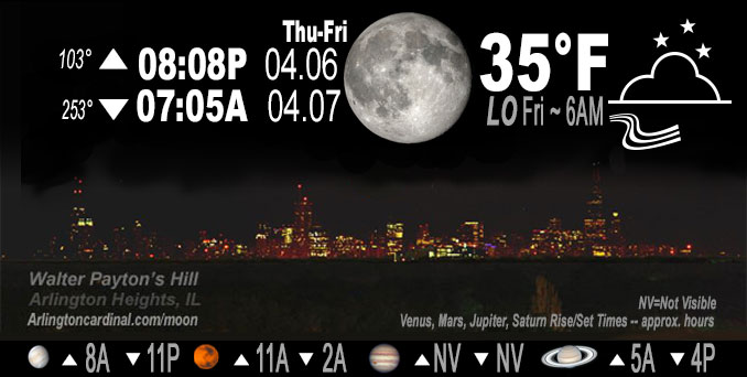
🌖 🌗 🌑 🌓 Waning Gibbous Moon, sky cover overnight Thu. to Fri. 32% to 3%, winds W to N, 10 to 3 to 5 MPH, Low 35, 6a to 7a

NWS CHGO | NWS HRLY | /NWSchicago | 🌡
ARLINGTON HEIGHTS WEATHER
▴ forecast7 (Arl. Hts.) | RADAR | WIDE RADAR
IMPORTANT NOTE ON NWS DATA
Hello mobile users! If you encounter a mobile “unfriendly” weather page, turn your phone sideways for a better view.
======================
NIGHT FORECASTS …
NOTE: Keep in mind lunar rise and set times don’t always correspond with night weather and early morning lows because on some days during the month the moon is visible in the sky predominantly during the daytime hours.
Overnight Thursday/Friday …
Weather Hazards expected …
Thursday…
Elevated Fire Weather Risk ending Thursday night.
DISCUSSION…
The combination of breezy westerly winds gusting upwards of 25 to 30 mph and low relative humidities in the 25 to 35 percent range Thursday afternoon will make for an elevated risk of brush fire spread. Use caution if burning.
======================
O’HARE FORECAST …
Forecast Beginning Thursday Night, Apr. 06, 2023 …
Thursday Night: Mostly clear, with a low around 35. West wind 5 to 10 mph becoming north northeast after midnight.
Friday: Sunny, with a high near 54. East wind 5 to 10 mph becoming south southeast in the afternoon. Winds could gust as high as 15 mph.
Friday Night: Mostly clear, with a low around 37. East wind 5 to 10 mph.
Saturday: Mostly sunny, with a high near 60. Southeast wind 5 to 10 mph.
Saturday Night: Mostly clear, with a low around 41.
Sunday: Mostly sunny, with a high near 63.
Sunday Night: Mostly cloudy, with a low around 47.
Monday: Partly sunny, with a high near 66.
Monday Night: Partly cloudy, with a low around 49.
Tuesday: Mostly sunny, with a high near 72.
Tuesday Night: Mostly clear, with a low around 54.
Wednesday: Sunny, with a high near 77.
O’Hare forecast archive and hourly weather observations archive are available HERE on the CARDINAL NEWS Magazine.
Arlingtoncardinal.com/moonphases
Arlingtoncardinal.com/nightsky
NIGHT SKY THIS MONTH …
Check the night sky objects for this month and past months in the playlist from the Space Telescope Science Institute YouTube channel Backyard stargazers get a monthly guide to the northern hemisphere’s skywatching events with “Tonight’s Sky” (Musical track The Far River written by Jonn Serrie, from the album And the Stars Go With You courtesy of New World Music Ltd. Musical track The Far River written by Jonn Serrie, from the album And the Stars Go With You courtesy of New World Music Ltd).
Telephoto lens, ISO 100, f/11, Shutter Speed 1/100 to 1/125 for the Moon.
Get updates from The Cardinal ALL NEWS FEEDS on Facebook. Just ‘LIKE’ the ‘Arlington Cardinal Page (become a fan of our page). The updates cover all posts and sub-category posts from The Cardinal — Arlingtoncardinal.com. You can also limit feeds to specific categories. See all of The Cardinal Facebook fan pages at Arlingtoncardinal.com/about/facebook …
Help fund The Cardinal Arlingtoncardinal.com/sponsor
Telephoto lens, ISO 1600, f/11, Shutter Speed 2.5″ for the skyline. The skyline exposure was toned down, and brightness and contrast was adjusted in Photoshop.
/////////////>
Area Forecast Discussion
National Weather Service Chicago/Romeoville, IL
623 PM CDT Thu Apr 6 2023
.SHORT TERM… Issued at 209 PM CDT Thu Apr 6 2023
Through Friday night…
We`re looking at a very quiet end to an otherwise very busy week in weather. A large surface high centered over northern Missouri is keeping our environment nice and dry and is responsible for the mostly sunny skies today. Across parts of the southern and eastern CWA, a broken cirrus deck is on its way out of the area as the upper jet and the moisture tied to it continue to eject off to east. A marginally tight surface pressure gradient northeast of the high is providing us with a decent westerly breeze today. That breeze will let up through the evening as the high pressure center inches closer and the subsidence inversion takes hold and closes off all mixing.
The cool, dry airmass in place will pull Friday morning lows down near freezing with many likely to see sub-freezing temperatures. During the day on Friday, winds will turn around to southeasterly as they chase a weak warm frontal boundary taking shape up to the northwest. This will kick off a pleasant and lengthy warming trend for the area. More on that in the long term discussion below. Highs on Friday will reach the 50s for most. The western CWA may reach the lower 60s where the warm advection will be a bit more efficient. The easterly component to the wind will keep lakeside locales in the 40s and lower 50s. Another bright and sunny day will lead to another clear and cool night with temperatures dropping back into the 30s Friday night.
Doom/NWS Chicago

