
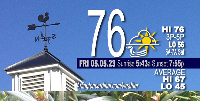
Friday Hi 76, partly cloudy, winds SSW to S to SE, 9 to 14 to 9 MPH, G20 to 23 to 18 MPH, 10a to 6p
NWS CHGO | NWS HRLY | /NWSchicago | 🌡
ARLINGTON HEIGHTS WEATHER
▴ forecast7 (Arl. Hts.) | RADAR | WIDE RADAR
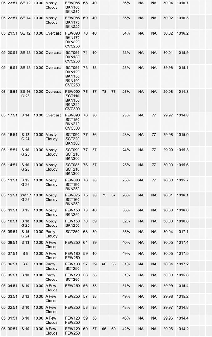
⏪ Hrly Data Table | Hrly Future Graph ⏩
IMPORTANT NOTE ON NWS DATA
⏪ Hrly Data Table | Hrly Future Graph ⏩
Hello mobile users! If you encounter a mobile “unfriendly” weather page, turn your phone sideways for a better view.
======================
Friday and Friday Evening …
Weather Hazards expected …
Elevated Fire Weather Risk.
Limited Thunderstorm Risk tonight.
DISCUSSION…
The combination of winds occasionally gusting to 25 mph, afternoon relative humidities as low as 25 percent, and dry fuels will result in a slightly elevated fire danger this afternoon.
Otherwise, a beautiful sunny day with high temperature forecast 76°F. Today looks to be mostly a repeat of yesterday, though stronger southerly winds probably will boost afternoon highs at least a couple of degrees warmer. Also like yesterday, ridging aloft, the lack of forcing at low levels, and fairly marginal moisture today should again limit precip chances during the daylight hours.
There is a small chance for a thunderstorm or two tonight. Severe weather is not expected.
======================
O’HARE FORECAST …
Forecast Beginning Friday, May 05, 2023
Friday: Mostly sunny, with a high near 77. South wind 10 to 15 mph, with gusts as high as 25 mph.
Friday Night: A slight chance of showers before 3am, then a chance of showers and thunderstorms between 3am and 4am, then a chance of showers after 4am. Mostly cloudy, with a low around 56. South southeast wind around 10 mph. Chance of precipitation is 30%.
Saturday: A 30 percent chance of showers, mainly before 11am. Partly sunny, with a high near 75. South southeast wind 10 to 15 mph, with gusts as high as 25 mph.
Saturday Night: A 50 percent chance of showers and thunderstorms, mainly after 10pm. Mostly cloudy, with a low around 62. South wind 10 to 15 mph, with gusts as high as 25 mph.
Sunday: A chance of showers and thunderstorms before 1pm, then a chance of showers between 1pm and 4pm, then a chance of showers and thunderstorms after 4pm. Partly sunny, with a high near 82. South southwest wind around 10 mph. Chance of precipitation is 40%.
Sunday Night: A 50 percent chance of showers and thunderstorms. Mostly cloudy, with a low around 58.
Monday: A 50 percent chance of showers and thunderstorms. Partly sunny, with a high near 77.
Monday Night: A chance of showers. Mostly cloudy, with a low around 56.
Tuesday: Mostly sunny, with a high near 72.
Tuesday Night: Partly cloudy, with a low around 50.
Wednesday: Mostly sunny, with a high near 70.
Wednesday Night: Partly cloudy, with a low around 51.
Thursday: Mostly sunny, with a high near 75.


CHICAGOWEATHERSTATION.COM

ChicagoWeatherStation.com I O’Hare Normal Temps/Precip I O’Hare Record Temps, Precip, Snow
WunderMap® with Temperature/Wind Data || Google: Arlington Heights Area Temps | US TEMPS
Midwest Cloud Cover with Arlington Heights Weather Forecast
ChicagoWeatherStation.com I O’Hare Normal Temps/Precip I O’Hare Record Temps, Precip, Snow
SUNLIGHT DATA FOR SECURITY, TRAFFIC SAFETY, AND SPORTS
SunCalc.net data with solar azimuth and trajectory, times for dawn, sunrise, solar noon, sunset, dusk …
NIGHT SKY THIS MONTH …
Backyard stargazers get a monthly guide to the northern hemisphere’s skywatching events with “Tonight’s Sky.” Check the night sky objects for this month and past months in the playlist from the Space Telescope Science Institute YouTube channel (Musical track The Far River written by Jonn Serrie, from the album And the Stars Go With You courtesy of New World Music Ltd).
Get updates from The Cardinal ALL NEWS FEEDS on Facebook. Just ‘LIKE’ the ‘Arlington Cardinal Page (become a fan of our page). The updates cover all posts and sub-category posts from The Cardinal — Arlingtoncardinal.com. You can also limit feeds to specific categories. See all of The Cardinal Facebook fan pages at Arlingtoncardinal.com/about/facebook …
Help fund The Cardinal Arlingtoncardinal.com/sponsor
/////////////>
Area Forecast Discussion
National Weather Service Chicago/Romeoville, IL
621 AM CDT Fri May 5 2023
.SHORT TERM… Issued at 325 AM CDT Fri May 5 2023
Through Saturday…
Today looks to be mostly a repeat of yesterday, though stronger southerly winds probably will boost afternoon highs at least a couple of degrees warmer. Also like yesterday, ridging aloft, the lack of forcing at low levels, and fairly marginal moisture today should again limit precip chances during the daylight hours.
Most of the models are in pretty good agreement regarding this trend, but some do start to show chances increase during the evening, mainly in our west and especially in our northwest, as shortwave energy traverses the upper ridge in conjunction with moderate strengthening of the low level jet. Forcing does not appear to be all that focused or pronounced, but there does seem to be decent support for the idea that the activity presently over Nebraska, or at least the dynamics associated with this activity, will slowly work east and move across northern IL and southern WI during the overnight hours into early Saturday.
A diminishing low level jet and height rises aloft should bring an end to most this activity by Saturday morning, but a few showers could linger into the early daylight hours. Saturday afternoon then looks dry again despite increasing low level moisture and steepening mid-level lapse rates, mainly due to the fairly pronounced cap that would be in place. Afternoon highs Saturday should top out near or just slightly cooler than Friday due to more persistent cloud cover.
Lenning/NWS Chicago
