
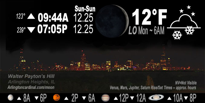
🌒 🌓 🌕 🌗 Waxing Crescent Moon, light snow, sky cover overnight Sun. to Mon. 60% to 96% to 88%, winds WSW to S to SW, 9 to 3 MPH, G15 to 13 MPH, Low 12, 6a
NWS CHGO | NWS HRLY | /NWSchicago | 🌡
ARLINGTON HEIGHTS WEATHER
▴ forecast7 (Arl. Hts.) | RADAR | WIDE RADAR
IMPORTANT NOTE ON NWS DATA
======================
Overnight Sunday/Monday …
Weather hazards expected
Limited Snow Risk in the morning.
Limited Excessive Cold Risk overnight.
DISCUSSION…
A period of accumulating snow this morning will likely lead to slick spots on roadways and some hazardous travel.
Temperatures are expected to dip into the single digits tonight which may lead to some subzero wind chills heading into Monday morning. Bundle up before heading out.
Hello mobile users! If you encounter mobile “unfriendly” weather page, turn your phone sideways for a better view.
======================
O’HARE FORECAST …
Forecast Beginning Sunday Night, Dec. 25, 2022 …
Christmas Night: Snow likely, mainly after 2am. Mostly cloudy, with a steady temperature around 13. Wind chill values as low as -1. West southwest wind 5 to 10 mph becoming south after midnight. Winds could gust as high as 15 mph. Chance of precipitation is 60%. New snow accumulation of less than one inch possible.
Monday: Snow likely, mainly before 11am. Cloudy, then gradually becoming mostly sunny, with a high near 20. Calm wind becoming northwest around 5 mph in the afternoon. Chance of precipitation is 60%. New snow accumulation of less than a half inch possible.
Monday Night: Partly cloudy, with a low around 8. Wind chill values as low as -2. West northwest wind around 5 mph, with gusts as high as 10 mph.
Tuesday: Partly sunny, with a high near 26. South southwest wind 5 to 15 mph, with gusts as high as 20 mph.
Tuesday Night: Mostly cloudy, with a low around 22.
Wednesday: Partly sunny, with a high near 41.
Wednesday Night: Mostly cloudy, with a low around 35.
Thursday: Cloudy, with a high near 49.
Thursday Night: A chance of rain. Cloudy, with a low around 43.
Friday: Rain likely. Cloudy, with a high near 52.
Friday Night: Rain likely. Cloudy, with a low around 43.
Saturday: Rain likely. Cloudy, with a high near 50.
O’Hare forecast archive and hourly weather observations archive are available HERE on the CARDINAL NEWS Magazine.
Arlingtoncardinal.com/moonphases
Arlingtoncardinal.com/nightsky
NIGHT SKY THIS MONTH …
Check the night sky objects for this month and past months in the playlist from the Space Telescope Science Institute YouTube channel Backyard stargazers get a monthly guide to the northern hemisphere’s skywatching events with “Tonight’s Sky” (Musical track The Far River written by Jonn Serrie, from the album And the Stars Go With You courtesy of New World Music Ltd. Musical track The Far River written by Jonn Serrie, from the album And the Stars Go With You courtesy of New World Music Ltd).
Telephoto lens, ISO 100, f/11, Shutter Speed 1/100 to 1/125 for the Moon.
Get updates from The Cardinal ALL NEWS FEEDS on Facebook. Just ‘LIKE’ the ‘Arlington Cardinal Page (become a fan of our page). The updates cover all posts and sub-category posts from The Cardinal — Arlingtoncardinal.com. You can also limit feeds to specific categories. See all of The Cardinal Facebook fan pages at Arlingtoncardinal.com/about/facebook …
Help fund The Cardinal Arlingtoncardinal.com/sponsor
Telephoto lens, ISO 1600, f/11, Shutter Speed 2.5″ for the skyline. The skyline exposure was toned down, and brightness and contrast was adjusted in Photoshop.
Area Forecast Discussion
National Weather Service Chicago/Romeoville, IL
1110 PM CST Sun Dec 25 2022
.UPDATE… Issued at 840 PM CST Sun Dec 25 2022
The forecast is largely on track for the overnight and Monday morning light snow. This evening`s adjustments were to nudge back onset time and increase PoPs Monday morning for a slightly slower end time. No changes to impacts from what has been messaged earlier, and that is a minor accumulating snow event occurring with very cold ground temperatures that will result in at least some locally hazardous travel conditions due to slick roads.
The well-defined, closed upper level wave of interest is over southwest Minnesota this evening and churning its way south- southeast. This path provides a glancing blow to the CWA of its warm advection late tonight and then its weakly defined deformation Monday morning and early afternoon. The warm advection ascent has been at first largely used to moisten a dry low-level atmosphere as seen on the 00Z DVN sounding, with much of the echoes from southwest Wisconsin through western Illinois as of 930 PM not reaching the ground. But as it moistens, snow does start and the leading edge of this is along the Mississippi River. Within the warm advection, we expect the general precipitation area to continue eastward expansion while the wave itself progresses south-southeast. This favors especially the southwest half of the forecast area overnight to see persistent light snowfall rates, especially as that feature somewhat pivots. Frontogenesis (f-gen) signatures within various layers in the lower to mid-levels within this zone are transient, so not a clear signature where persistent heavier rates may manifest themselves. In the favorable side of things, there is a dee Pdendritic growth zone (DGZ) or near-DGZ from the surface up to around 800 mb (~7,000 ft), as well as some steep lapse rates well aloft. With light winds in the sub-cloud layer, flake fragmentation will be limited as well. So could see some healthy ratios of near 20:1, just with minimal overall QPF.
For the post-sunrise part of Monday morning, forcing for ascent becomes weaker and less focused, but saturation in the DGZ remains deep in a synoptically-favorable area for some precipitation. So light accumulating snow to at times just flurries, maybe of a more off-and-on nature, should continue a majority of the morning and probably even the first half of the afternoon south of I-80. Total event accumulations of 1 to 2 inches still look reasonable across the western and southern forecast with less north and east. Impact-wise, this does overla Pa Monday morning commute, granted more reduced one than typical with the holiday. Will continue the Special Weather Statement and associated messaging for some slick travel, and encourage folks to plan for ample extra time and using caution Monday morning.
MTF/NWS Chicago
