
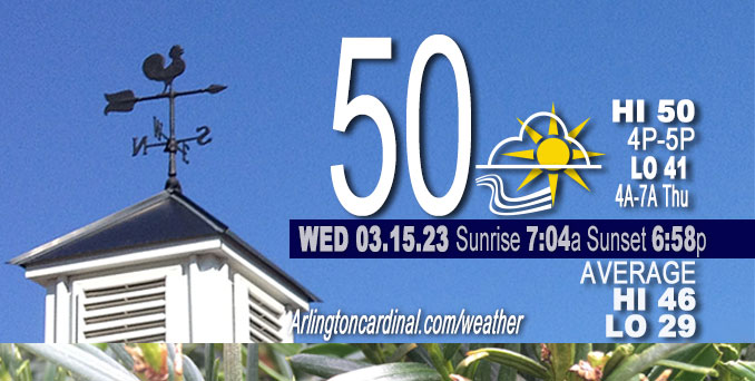
Wednesday Hi 50, mostly sunny then mostly cloudy 5p, winds SSE to SSW to S, 8 to 16 MPH, G13 to 28 MPH continuing Thursday
NWS CHGO | NWS HRLY | /NWSchicago | 🌡
ARLINGTON HEIGHTS WEATHER
▴ forecast7 (Arl. Hts.) | RADAR | WIDE RADAR
⏪ Hrly Data Table | Hrly Future Graph ⏩
IMPORTANT NOTE ON NWS DATA
⏪ Hrly Data Table | Hrly Future Graph ⏩
Hello mobile users! If you encounter a mobile “unfriendly” weather page, turn your phone sideways for a better view.
======================
Wednesday and Wednesday Evening …
No Weather Hazards expected …
Breezy south winds Wednesday and Thursday ushering in highs a few degrees above mid March normals; but when the high temperature is 50°F, the wind chill will be about 44°F.
DISCUSSION…
Rain spreading in Thursday during the late morning and afternoon and ending Thursday night from west to east.
Lows back above freezing and actually warmer than recent high temperatures at 41°F.
======================
O’HARE FORECAST …
Forecast Beginning Wednesday, Mar. 15, 2023
Wednesday: Increasing clouds, with a high near 50. South wind 5 to 15 mph, with gusts as high as 25 mph.
Wednesday Night: Mostly cloudy, with a low around 41. South wind around 15 mph, with gusts as high as 30 mph.
Thursday: Rain, mainly after 2pm. High near 50. South wind around 15 mph, with gusts as high as 30 mph. Chance of precipitation is 90%. New precipitation amounts between a tenth and quarter of an inch possible.
Thursday Night: Rain. Low around 36. South wind around 10 mph becoming west after midnight. Winds could gust as high as 25 mph. Chance of precipitation is 90%.
Friday: Rain likely, possibly mixing with snow after 8am, then gradually ending. Cloudy, with a high near 37. Breezy, with a west northwest wind 15 to 25 mph, with gusts as high as 40 mph. Chance of precipitation is 60%.
Friday Night: A 20 percent chance of snow after 8pm. Mostly cloudy, with a low around 21. Blustery.
Saturday: A 20 percent chance of snow. Mostly cloudy, with a high near 29. Breezy.
Saturday Night: Mostly cloudy, with a low around 22.
Sunday: Mostly sunny, with a high near 37.
Sunday Night: Mostly clear, with a low around 25.
Monday: Mostly sunny, with a high near 44.
Monday Night: Partly cloudy, with a low around 31.
Tuesday: Partly sunny, with a high near 46.


CHICAGOWEATHERSTATION.COM

ChicagoWeatherStation.com I O’Hare Normal Temps/Precip I O’Hare Record Temps, Precip, Snow
LIVE RADAR | STORM TRACKS | UNISYS US IR SAT | UNISYS Midwest IR SAT | UNISYS More IR SAT
WunderMap® with Temperature/Wind Data || Google: Arlington Heights Area Temps | US TEMPS
Full Screen Motion Weather Radar (Wunderground.com)
Midwest Cloud Cover with Arlington Heights Weather Forecast
ChicagoWeatherStation.com I O’Hare Normal Temps/Precip I O’Hare Record Temps, Precip, Snow
SUNLIGHT DATA FOR SECURITY, TRAFFIC SAFETY, AND SPORTS
SunCalc.net data with solar azimuth and trajectory, times for dawn, sunrise, solar noon, sunset, dusk …
NIGHT SKY THIS MONTH …
Backyard stargazers get a monthly guide to the northern hemisphere’s skywatching events with “Tonight’s Sky.” Check the night sky objects for this month and past months in the playlist from the Space Telescope Science Institute YouTube channel (Musical track The Far River written by Jonn Serrie, from the album And the Stars Go With You courtesy of New World Music Ltd).
Get updates from The Cardinal ALL NEWS FEEDS on Facebook. Just ‘LIKE’ the ‘Arlington Cardinal Page (become a fan of our page). The updates cover all posts and sub-category posts from The Cardinal — Arlingtoncardinal.com. You can also limit feeds to specific categories. See all of The Cardinal Facebook fan pages at Arlingtoncardinal.com/about/facebook …
Help fund The Cardinal Arlingtoncardinal.com/sponsor
Area Forecast Discussion
National Weather Service Chicago/Romeoville, IL
610 AM CDT Wed Mar 15 2023
.SHORT TERM… Issued at 235 AM CDT Wed Mar 15 2023
Through Thursday Night…
Key Messages:
* Breezy south winds today and Thursday ushering in highs a few degrees above mid March normals
* Rain spreading in Thursday during the late morning and afternoon and ending Thursday night from west to east
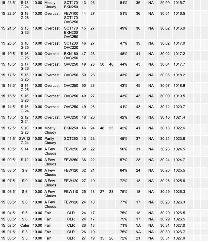
Satellite water vapor imagery shows broad scale upper level ridging sliding its way eastward over the area, with the embedded exception of a dampening short wave across eastern Iowa. This wave will provide some mid clouds at daybreak for northern Illinois that will quickly fade. The surface pressure gradient will tighten today well in advance of lee-side cyclogenesis in the western Plains, and the result will be southerly winds gusting to 20 to 25 mph this afternoon. The 925 mb temperatures will swing to the plus side of 0C, supportive of highs around 50F. The last of the snow cover in the far northern CWA should melt today but may thwart the highs a couple degrees shy of 50F, while south and into Chicago might exceed 50F by a few degrees.
Clouds will thicken late day into tonight, which combined with breezy southerly winds will prevent much of a temperature drop. The trend in guidance for onset of rain has inched later, with likely better handling of the inherent dry air mass in place. So no rain is in the forecast for late tonight.
An upper trough over the Intermountain West on Thursday morning will shift into the Midwest during Thursday afternoon and gradually deepen as it does. Increasing diffluence aloft ahead of the system and a draw of precipitable waters of 1 to 1.2 inches from the western Gulf will result in rain blossoming over the Mid Mississippi Valley Thursday morning that will then advance over the area. In the absence of any strong mid-level cooling, the elevated lapse rates are not forecast to be that steep (6-6.5 C/km) so not seeing a signal for thunder. But rain should have a sizable footprint by early afternoon over the area. This will keep highs from reaching full potential, and look to be similar to today despite temperatures starting the day much milder. The rain, likely becoming more shower-y, should continue until a cold frontal passage later Thursday night/early Friday morning.
Total rainfall is forecast to be one half and three quarters of an inch for most of the CWA, and both the GEFS and ECMWF ensemble spreads support that “bin” being the most probable for rainfall amounts. This should be an amount that drainage and rivers will be able to handle.
MTF/NWS Chicago
