
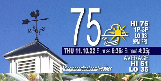
THURSDAY Hi 75, partly cloudy, increasing clouds, winds to S to SW, 18 to 14 to 11 MPH, G30 to 31 to 20 MPH
NWS CHGO | NWS HRLY | /NWSchicago | 🌡
ARLINGTON HEIGHTS WEATHER
▴ forecast7 (Arl. Hts.) | RADAR | WIDE RADAR
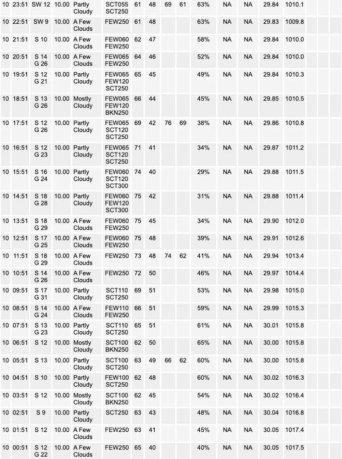
⏪ Hrly Data Table | Hrly Future Graph ⏩
IMPORTANT NOTE ON NWS DATA
⏪ Hrly Data Table | Hrly Future Graph ⏩
======================
Thursday …
Weather hazards expected…
Elevated Fire Weather Risk southeast of I-55.
Limited Thunderstorm Risk west of I-39 early this evening.
Limited Non Thunderstorm Wind Risk.
DISCUSSION…
The main weather highlight include:
* Breezy south winds with near record to record high temperatures into the mid 70s today.
* Chance of showers for some tonight as a strong cold front sweeps eastward across the area.
* Much colder weather (40s and 30s) expected in the wake of the front for Friday onward.
Hello mobile users! If you encounter mobile “unfriendly” weather page, turn your phone sideways for a better view.
======================
Hazardous Weather Outlook
National Weather Service Chicago/Romeoville IL
1002 AM CST Thu Nov 10 2022
Winnebago-Boone-McHenry-Lake IL-Ogle-Lee-De Kalb-Kane-DuPage-La Salle-Kendall-Grundy-Kankakee-Livingston-Iroquois-Ford-Northern Cook-Central Cook-Southern Cook-Northern Will-Southern Will-Eastern Will-Lake IN-Porter-Newton-Jasper-Benton-
1002 AM CST Thu Nov 10 2022 /1102 AM EST Thu Nov 10 2022
This Hazardous Weather Outlook is for portions of North Central Illinois…Northeast Illinois and Northwest Indiana.
Thursday and Thursday night …
Weather hazards expected…
Elevated Fire Weather Risk southeast of I-55.
Limited Thunderstorm Risk west of I-39 early this evening.
Limited Non Thunderstorm Wind Risk.
DISCUSSION…
Dry conditions and gusty south winds will combine to produce an elevated risk of rapidly spreading wildfires this afternoon across much of the area, but especially southeast of I-55.
A line of showers and thunderstorms is expected to move into northwestern Illinois early this evening as a cold front approaches. While these storms may produce some strong wind gusts as they approach
the Mississippi river late this afternoon, they are expected to weaken quickly with eastward extent into northwestern Illinois early this evening.
O’HARE FORECAST …
Forecast Beginning Thursday, Nov. 10, 2022
Thursday: Mostly sunny, with a high near 75. Breezy, with a south wind 15 to 20 mph, with gusts as high as 30 mph.
Thursday Night: A 30 percent chance of showers, mainly after 3am. Mostly cloudy, with a low around 44. South wind 10 to 15 mph becoming northwest after midnight. Winds could gust as high as 30 mph.
Veterans Day: Cloudy, then gradually becoming mostly sunny, with a temperature falling to around 38 by 4pm. Northwest wind around 15 mph, with gusts as high as 25 mph.
Friday Night: Increasing clouds, with a low around 31. Northwest wind 10 to 15 mph, with gusts as high as 20 mph.
Saturday: A chance of flurries. Mostly cloudy, with a high near 39. West northwest wind 10 to 15 mph, with gusts as high as 20 mph.
Saturday Night: A chance of flurries before midnight. Partly cloudy, with a low around 26.
Sunday: Mostly sunny, with a high near 38.
Sunday Night: Mostly cloudy, with a low around 26.
Monday: Mostly cloudy, with a high near 41.
Monday Night: A chance of snow after midnight. Mostly cloudy, with a low around 31.
Tuesday: A chance of rain and snow. Mostly cloudy, with a high near 40.
Tuesday Night: Mostly cloudy, with a low around 27.
Wednesday: Partly sunny, with a high near 39.


CHICAGOWEATHERSTATION.COM

ChicagoWeatherStation.com I O’Hare Normal Temps/Precip I O’Hare Record Temps, Precip, Snow
LIVE RADAR | STORM TRACKS | UNISYS US IR SAT | UNISYS Midwest IR SAT | UNISYS More IR SAT
WunderMap® with Temperature/Wind Data || Google: Arlington Heights Area Temps | US TEMPS
Full Screen Motion Weather Radar (Wunderground.com)
Midwest Cloud Cover with Arlington Heights Weather Forecast
ChicagoWeatherStation.com I O’Hare Normal Temps/Precip I O’Hare Record Temps, Precip, Snow
SUNLIGHT DATA FOR SECURITY, TRAFFIC SAFETY, AND SPORTS
SunCalc.net data with solar azimuth and trajectory, times for dawn, sunrise, solar noon, sunset, dusk …
NIGHT SKY THIS MONTH …
Backyard stargazers get a monthly guide to the northern hemisphere’s skywatching events with “Tonight’s Sky.” Check the night sky objects for this month and past months in the playlist from the Space Telescope Science Institute YouTube channel (Musical track The Far River written by Jonn Serrie, from the album And the Stars Go With You courtesy of New World Music Ltd).
Get updates from The Cardinal ALL NEWS FEEDS on Facebook. Just ‘LIKE’ the ‘Arlington Cardinal Page (become a fan of our page). The updates cover all posts and sub-category posts from The Cardinal — Arlingtoncardinal.com. You can also limit feeds to specific categories. See all of The Cardinal Facebook fan pages at Arlingtoncardinal.com/about/facebook …
Help fund The Cardinal Arlingtoncardinal.com/sponsor
Area Forecast Discussion
National Weather Service Chicago/Romeoville, IL
517 AM CST Thu Nov 10 2022
.SHORT TERM…
Issued at 250 AM CST Thu Nov 10 2022
Through Friday…
The main forecast highlights for the short term period include:
* Breezy south winds with near record to record high temperatures into the mid 70s today.
* Chance of showers for some tonight as a strong cold front sweeps eastward across the area tonight.
* Much colder weather expected in the wake of the front for Friday onward.
Water vapor channels on the GOES 16 indicate that the upper trough over the northern Rockies is beginning to show signs of ejecting a significant impulse northeastward out across the northern High Plains early this morning. As it occurs, we will see surface low pressure continue to consolidate across southwestern MN through the morning, before shifting eastward across Lake Superior tonight. This storm system will separate true winter conditions to its north and west from a near record breaking warmth to its south. As such, Blizzard conditions with significant snow and ice are expected today across the Dakotas eastward into northern MN, while near record high temperatures are expected into the Great Lakes. This will come to a quick end tonight, however, as a strong cold front sweeps eastward across the area.
Weather conditions across northern IL and northwestern IN today will feature near record high temperatures in the middle 70s as our area continues to experience a steady southward feed of warm air into the area. South winds will become increasingly gusty across the area through the day as the area of low pressure shifts eastward across MN and into northern WI through the afternoon. This is is expected to result in wind gusts flirting with 35 mph across a good chuck of the area this afternoon and evening. A line of showers and thunderstorms is also expected along the approaching cold front to our west and northwest this afternoon, and some of these storms could produce strong gusty winds, particularly over eastern IA northward into western WI.
The line of showers and thunderstorms is expected to move east of the Mississippi into northwestern IL around sunset this evening, then weaken as the progress eastward across northern IL with and in the wake of the cold front through the evening. Any chance for thunderstorms in our area will thus be limited to areas west of I-39 into very early this evening ~7 to 8 pm, before the threat ends. A period of showers does look to continue into tonight in the wake of the frontal boundary, especially northwest of the I-55 corridor, but these showers too will dissipate with time as they attempt to shift eastward into early Friday morning.
A much colder airmass will spill into the area in the wake of this frontal boundary tonight into early Friday morning as the winds become breezy from the northwest. High temperatures for many locations on Friday are likely be in the morning, with near steady or slowing falling temperatures into the upper 30s and low 40s through the day. Below normal weather will continue across the area into the long term period. See below for more details on this.
KJB/NWS Chicago
