
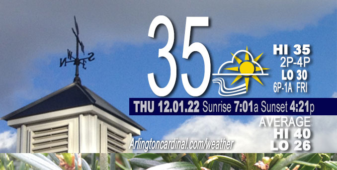
THURSDAY Hi 35, partly cloudy, winds W to SW to S, 8 to 14 to 16 MPH, G15 to 21 to 24 MPH
NWS CHGO | NWS HRLY | /NWSchicago | 🌡
ARLINGTON HEIGHTS WEATHER
▴ forecast7 (Arl. Hts.) | RADAR | WIDE RADAR
⏪ Hrly Data Table | Hrly Future Graph ⏩
IMPORTANT NOTE ON NWS DATA
⏪ Hrly Data Table | Hrly Future Graph ⏩
======================
Thursday and Thursday Night …
No Weather Hazards expected…
DISCUSSION…
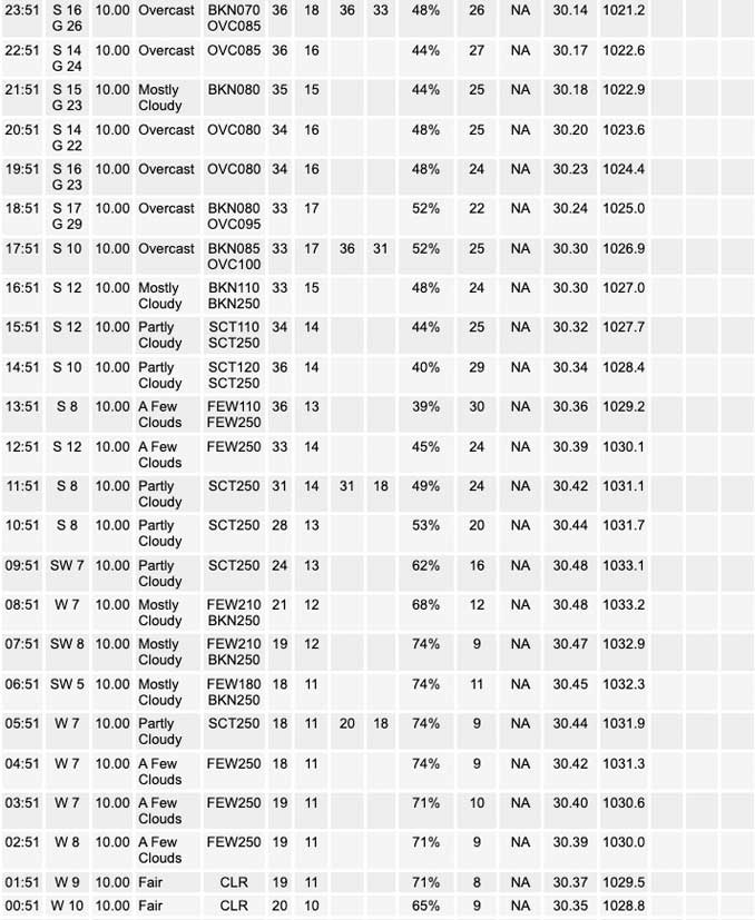
The Thursday morning low at NWS Chicago O’Hare was about 18°F and at Chicago Executive Airport was about 18°F (official pending), but in Arlington Heights at CARDINAL NEWS, the morning low was 16.5°F at about 6:00 a.m.
Thursday will be a little warmer and a little less gusty than Wednesday, then another quick-moving and temperature-swinging system will provide notably gusty winds Friday, overnight and through the day on Saturday, with the peak gusts nearing Wind Advisory criteria (45 mph) during overnight Friday night and Saturday morning hours.
The forecast indicates a cloudy, mild Friday with peak late day and evening temperatures around 50°F, but tumbling to the 20s by daybreak Saturday with accompanying single digit wind chills. The beginning of the temperature drop with the arrival of the cold front will be accompanied by southwest winds shifting to northwest winds.
There is a chance of rain showers and drizzle ahead of the Friday afternoon/evening cold front, which will probably strike Arlington Heights and the northwest suburbs beginning between 11:00 p.m. Friday and 12:00 a.m. Saturday. The temperature will be 50°F around midnight and 25°F by 6:00 a.m. Saturday.
Meteorologically speaking, during the immediate near term for Thursday, surface ridging extending from a 1035 mb high pressure will scoot over the area Thursday morning under some passing cirrus. Winds will turn southerly (from westerly) Thursday afternoon, and highs will reach a few degrees warmer than Wednesday despite Thursday`s cold start. Highs in the mid 30s on Thursday, December 1 will be about five degrees below normal. The south winds will hold in place Thursday evening and gradually uptick overnight, so after an early evening temperature drop (to 30°F, 6p to 1a), temperatures will hold steady or even climb beginning about 2:00 a.m. Friday. Then Friday won’t hit 50°F until about 5:00 p.m. — just about the time when the drizzle gets going. The temperature readings and winds will rise together on Friday during the day. The drizzle should end by midnight Friday/Saturday.
Hello mobile users! If you encounter mobile “unfriendly” weather page, turn your phone sideways for a better view.
======================
O’HARE FORECAST …
Forecast Beginning Thursday, Dec. 01, 2022
Thursday: Sunny, with a high near 36. West wind 10 to 15 mph becoming south in the afternoon. Winds could gust as high as 20 mph.
Thursday Night: Mostly clear, with a low around 30. South wind around 15 mph, with gusts as high as 30 mph.
Friday: A slight chance of drizzle or sprinkles after 3pm. Mostly cloudy, with a high near 50. Breezy, with a south wind 15 to 25 mph, with gusts as high as 35 mph.
Friday Night: A 30 percent chance of showers or drizzle before midnight. Cloudy, then gradually becoming partly cloudy, with a low around 23. Windy, with a south southwest wind 25 to 30 mph becoming west after midnight. Winds could gust as high as 45 mph.
Saturday: Sunny, with a high near 31. Windy, with a west northwest wind 20 to 30 mph decreasing to 10 to 20 mph in the afternoon. Winds could gust as high as 45 mph.
Saturday Night: Partly cloudy, with a low around 18.
Sunday: Mostly sunny, with a high near 40.
Sunday Night: Partly cloudy, with a low around 23.
Monday: A chance of rain after noon. Mostly cloudy, with a high near 42.
Monday Night: A chance of rain and snow before midnight. Mostly cloudy, with a low around 28.
Tuesday: Partly sunny, with a high near 37.
Tuesday Night: Partly cloudy, with a low around 20.
Wednesday: Mostly sunny, with a high near 36.


CHICAGOWEATHERSTATION.COM

ChicagoWeatherStation.com I O’Hare Normal Temps/Precip I O’Hare Record Temps, Precip, Snow
LIVE RADAR | STORM TRACKS | UNISYS US IR SAT | UNISYS Midwest IR SAT | UNISYS More IR SAT
WunderMap® with Temperature/Wind Data || Google: Arlington Heights Area Temps | US TEMPS
Full Screen Motion Weather Radar (Wunderground.com)
Midwest Cloud Cover with Arlington Heights Weather Forecast
ChicagoWeatherStation.com I O’Hare Normal Temps/Precip I O’Hare Record Temps, Precip, Snow
SUNLIGHT DATA FOR SECURITY, TRAFFIC SAFETY, AND SPORTS
SunCalc.net data with solar azimuth and trajectory, times for dawn, sunrise, solar noon, sunset, dusk …
NIGHT SKY THIS MONTH …
Backyard stargazers get a monthly guide to the northern hemisphere’s skywatching events with “Tonight’s Sky.” Check the night sky objects for this month and past months in the playlist from the Space Telescope Science Institute YouTube channel (Musical track The Far River written by Jonn Serrie, from the album And the Stars Go With You courtesy of New World Music Ltd).
Get updates from The Cardinal ALL NEWS FEEDS on Facebook. Just ‘LIKE’ the ‘Arlington Cardinal Page (become a fan of our page). The updates cover all posts and sub-category posts from The Cardinal — Arlingtoncardinal.com. You can also limit feeds to specific categories. See all of The Cardinal Facebook fan pages at Arlingtoncardinal.com/about/facebook …
Help fund The Cardinal Arlingtoncardinal.com/sponsor
Area Forecast Discussion
National Weather Service Chicago/Romeoville, IL
553 AM CST Thu Dec 1 2022
.SHORT TERM… Issued at 310 AM CST Thu Dec 1 2022
Through Saturday…
The key forecast messages through the start of the weekend:
* Another quick-moving and temperature-swinging system to provide notably gusty winds Friday through the day Saturday, with the peak gusts nearing Wind Advisory criteria (45 mph) during overnight Friday night and Saturday morning
* Cloudy, mild Friday with peak late day and evening temperatures around 50f tumbling to the 20s by daybreak Saturday with accompanying single digit wind chills
* Chance of rain showers and drizzle ahead of that cold front Friday afternoon and mainly Friday evening
In the immediate near term for today, surface ridging extending from a 1035 mb high pressure will scoot over the area this morning under some passing cirrus. Winds will turn southerly this afternoon, and highs will reach a few degrees warmer than yesterday despite today`s cool start. Highs in the mid 30s will be five degrees below normal. The south winds will hold in place this evening and gradually uptick overnight, so after an early evening temperature drop they will hold steady or even climb.
The end of the week system is presently moving onshore the Pacific Northwest and bringing some atypical snow on this first morning of Meteorological Winter to Seattle and other coastal locations. This now closed upper level low will become more of an open wave and pick up eastward speed. This will ride within a 120+ kt upper jet around the southern periphery of the broad Rossby wave/polar vortex trough across northern Canada. Enhanced baroclinicity ahead of this system in the Midwest on Friday will help support a deepening and consolidating surface low over northern Minnesota late day Friday. A sharpening cold front extending southward from this low will sweep eastward through the Great Lakes Friday night. Conceptually with a quick eastward-migrating deep low near the international border and enhanced temperature gradient with this system, it is a solid setup for winds but once again not so much a good setup for any longer duration, heavy precipitation.
The tightening pressure gradient from this will quickly ramp u Psoutherly winds on Friday. But as is often the case in our area with warm sectors in the cool season, this looks laden with clouds during the day Friday. So there is fairly large uncertainty how high gusts will reach. There are multiple guidance solutions, including long range RAP runs, that do show gusts reaching 45 mph. With clouds expected to start the day and no breaks (in fact likely lowering cloud bases), it`s a little different than this past Tuesday`s southerly wind event, so have kept gusts more in the 35 to near 40 mph ballpark. But certainly potential for it to be higher since there is 40 kt indicated at 1,500 ft on several models by afternoon. This warm sector is also forecast to not be as warm because it`s on the heels of this morning`s cold air. So have highs being reached late day into the evening hours and those are around 50F.
The mass response ahead of this system is not long in duration but is enough to provide deep enough lower tropospheric moisture and low-level ascent for the likelihood of scattered showers and/or drizzle Friday afternoon into the evening. Cloud depths grow several thousand feet deep by late afternoon into evening when forecast soundings show support for both pockets of drizzle as well as some showers. The upper forcing strengthens quickly mid to late evening as the digging northern stream jet punches over the area, so would expect shower coverage to increase ahead of the incoming cold front with eastern extent based on current model timing. With this not being as robust of a warm sector, the MUCAPE axis for thunder potential is progged to remain southeast of the CWA. Any showers though immediately on the front will have potential for higher gusts than the ambient flow.
The strong cold front timing is presently well agreed upon guidance, with a passage Friday night between 10 PM and 3 AM. There is certainly time yet for this to wobble like we saw with the midweek system that shifted quicker. Immediately behind the cold front are the following ingredients: 1.) powerful cold advection on the order of temperatures dropping 20-25F in just 3-5 hours, 2.) strong dry advection with a lack of any stratocumulus, 3.) 40-45 kt top of the boundary layer flow, and 4.) eye-opening 15-18 mb/6 hr pressure rises. All of those point towards wind gusts having a likelihood to be near the top of the mixed layer channel winds (45-50 mph). The window of time for these highest gusts is limited because of the quick progression of the system and its strongest low-level cold conveyor belt surge. So by mid to late Saturday morning, wind should be gradually coming down and that rate of drop will hasten into the afternoon. This will allow temperatures and wind chills to recover some from their harshly cold start (relative to the prior evening).
MTF/NWS Chicago
