
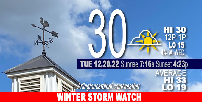
Tuesday Hi 30, partly cloudy to mostly cloudy to partly cloudy, winds SW to NW, 7 to 9 to 7 MPH
NWS CHGO | NWS HRLY | /NWSchicago | 🌡
ARLINGTON HEIGHTS WEATHER
▴ forecast7 (Arl. Hts.) | RADAR | WIDE RADAR
⏪ Hrly Data Table | Hrly Future Graph ⏩
IMPORTANT NOTE ON NWS DATA
⏪ Hrly Data Table | Hrly Future Graph ⏩
======================
Tuesday and Tuesday Night …
No Weather Hazards expected…
However, get prepared for …
WINTER STORM WATCH: Major storm system affecting the area Thursday through Saturday, with the most significant impacts from accumulating and blowing snow and very strong winds late Thursday afternoon into Friday night, and a low 2°F Friday morning with a high of 7°F, and then a low of 1°F Saturday morning with a high near 9°F Saturday. Christmas morning (Sunday morning) -2°F.
DISCUSSION…
No precipitation with variable cloud cover forecast for Tuesday.
Temperature forecasts for the Friday morning low temperature and the Friday high temperature in 24 hours have trended downward by 10°F (The Friday low forecast yesterday was Low 12°F, but is now Low 2°F; and the Friday High forecast yesterday was 17°F, but is now 7°F). The cold air mass approaching from the northwest will slowly bring colder air — Wednesday’s low of 15°F is forecast about 10°F colder than Tuesday’s actual morning low of 25°F.
The ECMWF (European model) for snow accumulation for the storm on Thursday and Friday has trended downward from about 7 inches to about 6 inches (Monday’s model run compared to Tuesday’s model run).
The GFS (United States NWS model) for snow accumulation for the storm on Thursday and Friday has trended upward from about 1 inch to about 3 inches (Monday’s model run compared to Tuesday’s model run).
Hello mobile users! If you encounter a mobile “unfriendly” weather page, turn your phone sideways for a better view.
======================
O’HARE FORECAST …
Forecast Beginning Tuesday, Dec. 20, 2022
Tuesday: Partly sunny, with a high near 30. South southwest wind 5 to 10 mph becoming northwest in the afternoon.
Tuesday Night: Partly cloudy, with a low around 15. North wind 5 to 10 mph.
Wednesday: Mostly cloudy, with a high near 29. North wind around 5 mph becoming southeast in the afternoon. Winds could gust as high as 10 mph.
Wednesday Night: A 30 percent chance of snow, mainly after 3am. Cloudy, with a low around 27. Southeast wind 5 to 10 mph, with gusts as high as 15 mph.
Thursday: Snow. High near 34. South southeast wind 10 to 15 mph becoming west northwest in the afternoon. Chance of precipitation is 100%.
Thursday Night: Snow. The snow could be heavy at times. Widespread blowing snow, mainly after midnight. Low around 2. Windy. Chance of precipitation is 100%.
Friday: Snow. The snow could be heavy at times. Widespread blowing snow. High near 7. Windy. Chance of precipitation is 80%.
Friday Night: A chance of snow. Widespread blowing snow. Mostly cloudy, with a low around 1. Windy.
Saturday: Areas of blowing snow. Mostly cloudy and cold, with a high near 10. Breezy.
Saturday Night: Mostly cloudy, with a low around -2. Breezy.
Christmas Day: Mostly sunny, with a high near 11.
Sunday Night: Mostly cloudy, with a low around 1.
Monday: Partly sunny, with a high near 18.


CHICAGOWEATHERSTATION.COM

ChicagoWeatherStation.com I O’Hare Normal Temps/Precip I O’Hare Record Temps, Precip, Snow
LIVE RADAR | STORM TRACKS | UNISYS US IR SAT | UNISYS Midwest IR SAT | UNISYS More IR SAT
WunderMap® with Temperature/Wind Data || Google: Arlington Heights Area Temps | US TEMPS
Full Screen Motion Weather Radar (Wunderground.com)
Midwest Cloud Cover with Arlington Heights Weather Forecast
ChicagoWeatherStation.com I O’Hare Normal Temps/Precip I O’Hare Record Temps, Precip, Snow
SUNLIGHT DATA FOR SECURITY, TRAFFIC SAFETY, AND SPORTS
SunCalc.net data with solar azimuth and trajectory, times for dawn, sunrise, solar noon, sunset, dusk …
NIGHT SKY THIS MONTH …
Backyard stargazers get a monthly guide to the northern hemisphere’s skywatching events with “Tonight’s Sky.” Check the night sky objects for this month and past months in the playlist from the Space Telescope Science Institute YouTube channel (Musical track The Far River written by Jonn Serrie, from the album And the Stars Go With You courtesy of New World Music Ltd).
Get updates from The Cardinal ALL NEWS FEEDS on Facebook. Just ‘LIKE’ the ‘Arlington Cardinal Page (become a fan of our page). The updates cover all posts and sub-category posts from The Cardinal — Arlingtoncardinal.com. You can also limit feeds to specific categories. See all of The Cardinal Facebook fan pages at Arlingtoncardinal.com/about/facebook …
Help fund The Cardinal Arlingtoncardinal.com/sponsor
Area Forecast Discussion
National Weather Service Chicago/Romeoville, IL
535 AM CST Tue Dec 20 2022
.SHORT TERM… Issued at 200 AM CST Tue Dec 20 2022
Through Wednesday…
Will be a pretty short discussion here for time, but altogether fairly quiet weather conditions during the short term. The key Messages through Wednesday are:
* Threat for freezing drizzle this morning in our northwest appears to be diminishing; still monitoring upstream trends, however.
* Leading edge of colder airmass arrives through the morning. Temperatures likely steady or even slowly falling NW of I-55 through the day.
* Quiet and cold tonight; lows in the single digits NW of I-55, teens to 20 SE.
* Low-level mass response ahead of powerhouse low begins on Wednesday. Warm advection will drive increasing cloud cover through the day. Small chance for freezing drizzle as low-levels saturate during the afternoon north of I-80. Too low of a chance for a mention in the grids right now.
Carlaw/NWS Chicago
