
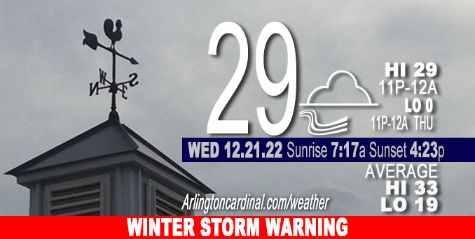
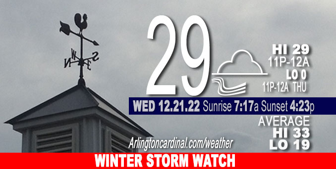
Wednesday Hi 29, mostly cloudy, winds NNE to E to SE, 6 to 5 to 7 to 5 MPH, G10 to 18 MPH, 6p through 12a Thursday
NWS CHGO | NWS HRLY | /NWSchicago | 🌡
ARLINGTON HEIGHTS WEATHER
▴ forecast7 (Arl. Hts.) | RADAR | WIDE RADAR
⏪ Hrly Data Table | Hrly Future Graph ⏩
IMPORTANT NOTE ON NWS DATA
⏪ Hrly Data Table | Hrly Future Graph ⏩
======================
Wednesday and Wednesday Night …
Weather Hazards expected…
Limited Snow Risk Wednesday night in northwest Illinois (west of I-39); flurries or light snow begins in Arlington Heights after midnight Wednesday/Thursday. CARDINAL NEWS FORECAST: Snow accumulation for O’Hare, Arlington Heights and nearby communities no more than 4.6 inches from 6 am Thursday to 5 pm Friday.
WINTER STORM WATCH: Major storm system affecting the area Thursday through Saturday, with the most significant impacts from accumulating and blowing snow and very strong winds occurring late Thursday afternoon into Friday night, and a low -4°F Friday morning with a high of 0°F, and then a low of -2°F Saturday morning with a high near 9°F Saturday. The forecast low for Christmas morning (Sunday morning) is -1°F.
DISCUSSION…
For Arlington Heights and nearby northwest suburbs, no precipitation with mostly cloudy conditions forecast for Wednesday.
High winds and extreme cold are the highlight hazards of the approaching winter storm for Thursday and Friday — even more so because snow accumulations continue to trend downward for Arlington Heights and nearby northwest communities. With a low around -4 Friday morning, wind chill is forecast down to -31°F from 6 am to 7 am. Wind Chill at the Chicago Bears game Saturday, Christmas Eve at the 12 p.m. kickoff is forecast at -10°F with wind gusts at 34 MPH.
The extreme cold from the cold air mass won’t strike the northwest suburbs near Arlington Heights until about 11 a.m. Thursday. Now hear this: After a High Temperature of 32° around 9 a.m. to 10 a.m. Thursday, air temperature will drop to 0°F by midnight Thursday/Friday. Temperature forecasts for the Friday morning low temperature and the Friday high temperature have trended downward again over the last 24 hours. The Friday morning low forecast yesterday was Low 2°F, but is now Low -4°F; and the Friday High forecast yesterday was 7°F, but is now 0°F. The forecast for Saturday’s High for the Chicago Bears game is about the same at 10°F (1 pm to 4 pm).
The ECMWF (European model) for snow accumulation for the storm on Thursday and Friday has trended downward again from about 6 inches to about 2 inches (Tuesday’s model run compared to Wednesday’s model run).
The GFS (United States NWS model) for snow accumulation for the storm on Thursday and Friday has trended upward slightly from about 3 inches to about 3.7 inches (Tuesday’s model run compared to Wednesday’s model run).
The forecast for potential blizzard conditions later Thursday night through daytime Friday with wind gusts over 50 mph is a little tentative if the snow accumulation forecast continues on a downward trend. However, Ground Blizzard conditions (a blizzard from only blowing snow) are likely even with just a few inches of snow on the ground. Blizzard or Ground Blizzard … either way, travel will be greatly affected, especially in open areas — and should be avoided.
Hello mobile users! If you encounter a mobile “unfriendly” weather page, turn your phone sideways for a better view.
======================
O’HARE FORECAST …
Forecast Beginning Wednesday, Dec. 21, 2022
Wednesday: Cloudy, with a high near 28. North wind around 5 mph becoming east southeast in the afternoon.
Wednesday Night: A chance of flurries between midnight and 3am, then a slight chance of snow after 3am. Cloudy, with a low around 28. East wind around 5 mph becoming south after midnight. Winds could gust as high as 20 mph. Chance of precipitation is 20%.
Thursday: Snow, mainly after 10am. Areas of blowing snow after 3pm. Temperature rising to near 33 by 9am, then falling to around 10 during the remainder of the day. Wind chill values as low as -9. Breezy, with a south wind 5 to 10 mph becoming west northwest 15 to 20 mph in the afternoon. Winds could gust as high as 35 mph. Chance of precipitation is 100%. New snow accumulation of 2 to 4 inches possible.
Thursday Night: Snow. Widespread blowing snow, mainly after midnight. Low around -4. Wind chill values as low as -30. Windy, with a west northwest wind 20 to 30 mph, with gusts as high as 45 mph. Chance of precipitation is 80%. New snow accumulation of less than one inch possible.
Friday: Scattered snow showers. Widespread blowing snow. Cloudy and cold, with a high near 0. Windy, with a west wind around 30 mph, with gusts as high as 50 mph. Chance of precipitation is 50%.
Friday Night: Isolated snow showers before midnight, then scattered flurries after midnight. Widespread blowing snow. Mostly cloudy, with a low around -2. Breezy. Chance of precipitation is 20%.
Saturday: Areas of blowing snow. Mostly sunny and cold, with a high near 9. Breezy.
Saturday Night: Mostly clear, with a low around -1.
Christmas Day: Sunny, with a high near 13.
Sunday Night: A chance of snow. Mostly cloudy, with a low around 8.
Monday: Mostly cloudy, with a high near 23.
Monday Night: Mostly cloudy, with a low around 8.
Tuesday: Partly sunny, with a high near 22.


CHICAGOWEATHERSTATION.COM

ChicagoWeatherStation.com I O’Hare Normal Temps/Precip I O’Hare Record Temps, Precip, Snow
LIVE RADAR | STORM TRACKS | UNISYS US IR SAT | UNISYS Midwest IR SAT | UNISYS More IR SAT
WunderMap® with Temperature/Wind Data || Google: Arlington Heights Area Temps | US TEMPS
Full Screen Motion Weather Radar (Wunderground.com)
Midwest Cloud Cover with Arlington Heights Weather Forecast
ChicagoWeatherStation.com I O’Hare Normal Temps/Precip I O’Hare Record Temps, Precip, Snow
SUNLIGHT DATA FOR SECURITY, TRAFFIC SAFETY, AND SPORTS
SunCalc.net data with solar azimuth and trajectory, times for dawn, sunrise, solar noon, sunset, dusk …
NIGHT SKY THIS MONTH …
Backyard stargazers get a monthly guide to the northern hemisphere’s skywatching events with “Tonight’s Sky.” Check the night sky objects for this month and past months in the playlist from the Space Telescope Science Institute YouTube channel (Musical track The Far River written by Jonn Serrie, from the album And the Stars Go With You courtesy of New World Music Ltd).
Get updates from The Cardinal ALL NEWS FEEDS on Facebook. Just ‘LIKE’ the ‘Arlington Cardinal Page (become a fan of our page). The updates cover all posts and sub-category posts from The Cardinal — Arlingtoncardinal.com. You can also limit feeds to specific categories. See all of The Cardinal Facebook fan pages at Arlingtoncardinal.com/about/facebook …
Help fund The Cardinal Arlingtoncardinal.com/sponsor
Area Forecast Discussion
National Weather Service Chicago/Romeoville, IL
541 AM CST Wed Dec 21 2022
.SHORT TERM… Issued at 133 AM CST Wed Dec 21 2022
Through Tonight…
Relatively quiescent weather conditions are expected through today and tonight (for the most part), although there are a few items of interest:
* Low/uncertain potential for freezing drizzle or flurries as a bank of low stratus drifts back northward through the day.
* Light snow expected to develop late tonight across parts of northwest Illinois. Threat for warm advection-driven rain/freezing drizzle south of the Kankakee River Valley towards daybreak.
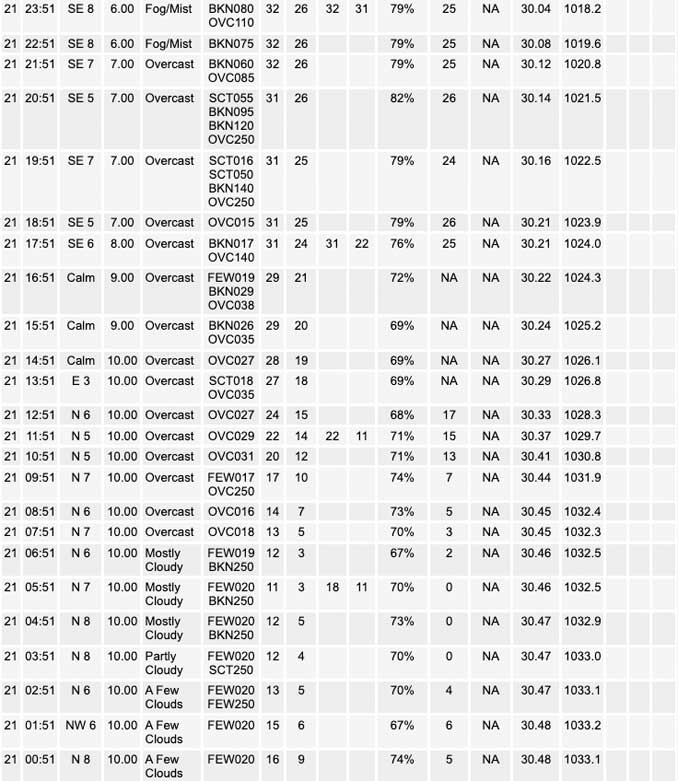
An expansive area of low stratus remains pooled across the southern half of the forecast area early this morning, and as the low-level flow continues to veer, this bank of cloud cover will begin to ooze back northward through the morning and afternoon. Some recent hires guidance has been attempting to crank out a little very light precipitation, mainly near the lake across northeast Illinois where a modest convergence axis if reflected. In addition, the RAP/HRRR depict an incremental deepening on the saturated lower levels (under 800 mb) through the day, especially as stratus pushes back north of I-80/88 during the afternoon. Verbatim, cloud depths would be deep enough given roughly 1 kft cloud bases to support drizzle given some very subtle ascent through the 900-800 mb layers.
Subsequent runs are trending deeper and deeper with this saturated layer, which isn`t great since p-type would likely be freezing drizzle due to warmer than -8 C cloud top temperatures. A 4-5 kft wedge of dry air atop this is probably a little too dee Pfor seeder-feeder assistance in getting some ice nucleation going. Guidance such as the ECMWF and RGEM are much less deeply saturated, so this casts a good deal of uncertainty on things for later today. For now, uncertainties suggest maintaining a “dry” forecast for the time being, but will be keeping a close eye on trends this morning.
Strengthening southerly flow will eventually scoot the lowest cloud cover north of the region, ending the threat for drizzle through the evening. A modest lead shortwave will encourage deeper tropospheric saturation through the overnight hours, and it looks like light snow will probably break out across our northwestern counties during the late overnight hours and into early Thursday morning. Snow quality may not be exceptional at this point given more ephemeral deeper saturation into the DGZ, but looks like a potential for up to a half inch or so of accumulation before daybreak. Farther south and east, drizzle, rain, freezing drizzle, and/or snow will be possible very early Thursday morning, although any activity at this time looks pretty spotty.
Carlaw/NWS Chicago
