
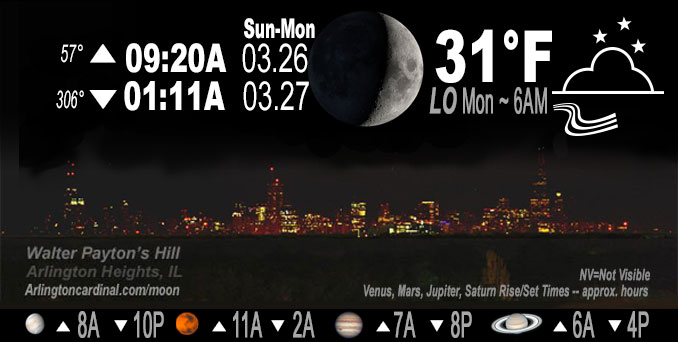
🌒 🌓 🌕 🌗 Waxing Crescent Moon, sky cover overnight Sun. to Mon. 92% to 39% to 36%, winds NE to N to NNE, 7 to 8 MPH, Low 31, 3a to 7a
NWS CHGO | NWS HRLY | /NWSchicago | 🌡
ARLINGTON HEIGHTS WEATHER
▴ forecast7 (Arl. Hts.) | RADAR | WIDE RADAR
IMPORTANT NOTE ON NWS DATA
Hello mobile users! If you encounter a mobile “unfriendly” weather page, turn your phone sideways for a better view.
======================
NIGHT FORECASTS …
NOTE: Keep in mind lunar rise and set times don’t always correspond with night weather and early morning lows because on some days during the month the moon is visible in the sky predominantly during the daytime hours.
Overnight Sunday/Monday …
No Weather Hazards expected …
Mostly cloudy, low 33, breezy to 20 MPH. Not likely, but maybe some snow flurries; radar clear at 11:30 p.m. Sunday.
DISCUSSION…
Sunday evening and into the early overnight hours, additional precipitation should develop with the deformation axis across northwest Illinois. Thermal profiles will initially support mainly rain, but a transition to a rain/snow mix or even all snow is possible after about 7-8 PM. There are some very minor snow accumulations in the gridded forecast north of about I-88. Any accumulations should be relegated to grassy or elevated surfaces, with precipitation expected to largely come to an end during the early overnight.
======================
O’HARE FORECAST …
Forecast Beginning Sunday Night, Mar. 26, 2023 …
Sunday Night: Mostly cloudy, with a low around 33. North wind 10 to 15 mph, with gusts as high as 20 mph.
Monday: Partly sunny, with a high near 42. North northeast wind 10 to 15 mph, with gusts as high as 20 mph.
Monday Night: Partly cloudy, with a low around 30. North northeast wind 5 to 10 mph.
Tuesday: Partly sunny, with a high near 47. Calm wind becoming west around 5 mph in the afternoon. Winds could gust as high as 10 mph.
Tuesday Night: Partly cloudy, with a low around 33. Southwest wind 5 to 10 mph, with gusts as high as 15 mph.
Wednesday: A chance of rain and snow. Mostly cloudy, with a high near 44. Breezy. Chance of precipitation is 30%.
Wednesday Night: Partly cloudy, with a low around 27.
Thursday: A chance of rain after 1pm. Mostly cloudy, with a high near 54.
Thursday Night: Rain, mainly after 1am. Mostly cloudy, with a low around 49. Breezy.
Friday: Rain. Mostly cloudy, with a high near 63. Breezy.
Friday Night: Rain likely. Mostly cloudy, with a low around 38. Breezy.
Saturday: A chance of rain and snow. Partly sunny, with a high near 46. Breezy.
Saturday Night: Partly cloudy, with a low around 29.
Sunday: Mostly sunny, with a high near 48.
O’Hare forecast archive and hourly weather observations archive are available HERE on the CARDINAL NEWS Magazine.
Arlingtoncardinal.com/moonphases
Arlingtoncardinal.com/nightsky
NIGHT SKY THIS MONTH …
Check the night sky objects for this month and past months in the playlist from the Space Telescope Science Institute YouTube channel Backyard stargazers get a monthly guide to the northern hemisphere’s skywatching events with “Tonight’s Sky” (Musical track The Far River written by Jonn Serrie, from the album And the Stars Go With You courtesy of New World Music Ltd. Musical track The Far River written by Jonn Serrie, from the album And the Stars Go With You courtesy of New World Music Ltd).
Telephoto lens, ISO 100, f/11, Shutter Speed 1/100 to 1/125 for the Moon.
Get updates from The Cardinal ALL NEWS FEEDS on Facebook. Just ‘LIKE’ the ‘Arlington Cardinal Page (become a fan of our page). The updates cover all posts and sub-category posts from The Cardinal — Arlingtoncardinal.com. You can also limit feeds to specific categories. See all of The Cardinal Facebook fan pages at Arlingtoncardinal.com/about/facebook …
Help fund The Cardinal Arlingtoncardinal.com/sponsor
Telephoto lens, ISO 1600, f/11, Shutter Speed 2.5″ for the skyline. The skyline exposure was toned down, and brightness and contrast was adjusted in Photoshop.
/////////////>
Area Forecast Discussion
National Weather Service Chicago/Romeoville, IL
631 PM CDT Sun Mar 26 2023
.SHORT TERM… Issued at 153 PM CDT Sun Mar 26 2023
Through Tonight…
Short term focus continues to be on the strong to severe thunderstorm potential this afternoon.
Surface analysis reveals the warm front is likely approaching La Salle to Joliet to Hebron or thereabouts. To the north, lake- enhanced push of cooler air with strengthening northeasterlies is evident, with temperatures dropping near the lake over the last hour. Latest thinking is the aforementioned locales represent a reasonable area for the eventual warm front to stall and set u Pshop the next few hours. To the south, surface dewpoints continue to inch their way into the mid and upper 40s. As mentioned previously, this is just about as low as we tend to see supportive of surface-based strong to severe convection and remains an overall limiting factor in the robustness of the threat today. That said, fairly cold temperatures aloft (around -9 C at 700 mb) and steepening low-level lapse rates may somewhat offset this, combined with the sharp nature of the attendant upper impulse. RAP forecasts depict a 50 ish knot 700 mb jet beginning to cross east of the Mississippi River, and this will drive commensurate increases in effective bulk shear towards 40-45 kts this afternoon supportive of low topped supercells.
Recent satellite loops show increasing bumpiness/congested Cu developing with MLCIN continuing to slowly erode. Convection should be initiating shortly. Based on the latest best guess where the stationary boundary will set up, the main axis favoring a brief tornado threat will be essentially about 20 miles or so either side of I-80. The brief tornado threat may also extend farther south of the Kankakee River, although more veered surface winds look to cut down on hodograph curvature to some degree. In this area, the locally damaging wind threat seems to be primary. The severe threat should wane after about 6-7 PM CDT with the loss of heating and instability.
This evening and into the early overnight hours, additional precipitation should develop with the deformation axis across northwest Illinois. Thermal profiles will initially support mainly rain, but a transition to a rain/snow mix or even all snow is possible after about 7-8 PM. Do have some very minor snow accumulations in the gridded forecast north of about I-88. Any accumulations should be relegated to grassy or elevated surfaces, with precipitation expected to largely come to an end during the early overnight.
Carlaw/NWS Chicago
