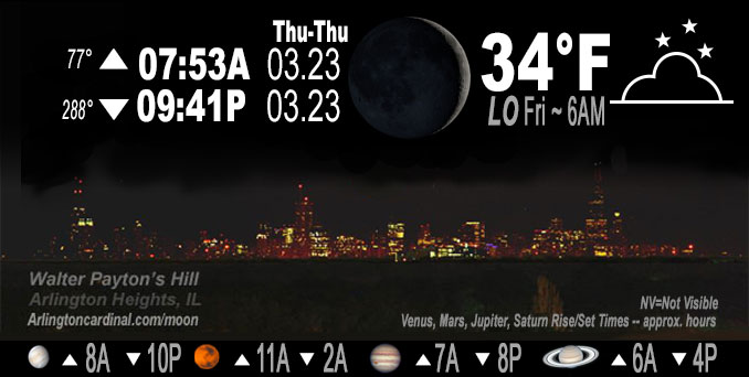
🌒 🌓 🌕 🌗 Waxing Crescent Moon, sky cover overnight Thu. to Fri. 80% to 56%, winds NE, 8 to 6 to 8 MPH, Low 34, 6a to 7a

NWS CHGO | NWS HRLY | /NWSchicago | 🌡
ARLINGTON HEIGHTS WEATHER
▴ forecast7 (Arl. Hts.) | RADAR | WIDE RADAR
IMPORTANT NOTE ON NWS DATA
Hello mobile users! If you encounter a mobile “unfriendly” weather page, turn your phone sideways for a better view.
======================
NIGHT FORECASTS …
NOTE: Keep in mind lunar rise and set times don’t always correspond with night weather and early morning lows because on some days during the month the moon is visible in the sky predominantly during the daytime hours.
Overnight Thursday/Friday …
No Weather Hazards expected
For Thursday night into Friday morning, the main focus is on the northern terminus on a developing slug of convection in response to rapidly-evolving/intensifying frontogenetic circulation. Guidance today seems to have shifted subtly northward with this, but even so, thinking is our area will remain largely dry with an exceptionally sharp cutoff to precipitation on the northern side.
DISCUSSION…
A post-frontal airmass has decidedly spread across the region with cooler conditions compared to this time yesterday across most of the area. There are no significant weather concerns the rest of the afternoon outside of trying to time the return of some late-day sun as low stratus attempts to scatter.
======================
O’HARE FORECAST …
Forecast Beginning Thursday Night, Mar. 23, 2023 …
Thursday Night: Mostly cloudy, with a low around 33. Northeast wind 5 to 10 mph.
Friday: A 20 percent chance of rain after 4pm. Mostly cloudy, with a high near 44. East northeast wind 10 to 15 mph, with gusts as high as 20 mph.
Friday Night: Rain before 4am, then rain, possibly mixed with snow. Low around 35. East northeast wind around 15 mph, with gusts as high as 30 mph. Chance of precipitation is 100%. Little or no snow accumulation expected.
Saturday: Rain and snow before 4pm, then a slight chance of rain. High near 39. Breezy, with a north northeast wind 15 to 20 mph becoming west in the afternoon. Winds could gust as high as 30 mph. Chance of precipitation is 80%. New snow accumulation of less than a half inch possible.
Saturday Night: Partly cloudy, with a low around 30. West wind 10 to 15 mph, with gusts as high as 20 mph.
Sunday: Mostly sunny, with a high near 48.
Sunday Night: A 20 percent chance of rain after 1am. Mostly cloudy, with a low around 33.
Monday: Partly sunny, with a high near 44.
Monday Night: Mostly cloudy, with a low around 32.
Tuesday: Partly sunny, with a high near 44.
Tuesday Night: Partly cloudy, with a low around 31.
Wednesday: Partly sunny, with a high near 50.
Wednesday Night: A chance of rain. Mostly cloudy, with a low around 40.
Thursday: A chance of rain. Partly sunny, with a high near 52.
O’Hare forecast archive and hourly weather observations archive are available HERE on the CARDINAL NEWS Magazine.
Arlingtoncardinal.com/moonphases
Arlingtoncardinal.com/nightsky
NIGHT SKY THIS MONTH …
Check the night sky objects for this month and past months in the playlist from the Space Telescope Science Institute YouTube channel Backyard stargazers get a monthly guide to the northern hemisphere’s skywatching events with “Tonight’s Sky” (Musical track The Far River written by Jonn Serrie, from the album And the Stars Go With You courtesy of New World Music Ltd. Musical track The Far River written by Jonn Serrie, from the album And the Stars Go With You courtesy of New World Music Ltd).
Telephoto lens, ISO 100, f/11, Shutter Speed 1/100 to 1/125 for the Moon.
Get updates from The Cardinal ALL NEWS FEEDS on Facebook. Just ‘LIKE’ the ‘Arlington Cardinal Page (become a fan of our page). The updates cover all posts and sub-category posts from The Cardinal — Arlingtoncardinal.com. You can also limit feeds to specific categories. See all of The Cardinal Facebook fan pages at Arlingtoncardinal.com/about/facebook …
Help fund The Cardinal Arlingtoncardinal.com/sponsor
Telephoto lens, ISO 1600, f/11, Shutter Speed 2.5″ for the skyline. The skyline exposure was toned down, and brightness and contrast was adjusted in Photoshop.
/////////////>
Area Forecast Discussion
National Weather Service Chicago/Romeoville, IL
632 PM CDT Thu Mar 23 2023
.SHORT TERM… Issued at 206 PM CDT Thu Mar 23 2023
Through Friday night…
A post-frontal airmass has decidedly spread across the region with cooler conditions compared to this time yesterday across most of the area. There are no significant weather concerns the rest of the afternoon outside of trying to time the return of some late-day sun as low stratus attempts to scatter.
For tonight and into Friday morning, the main focus is on the northern terminus on a developing slug of convection in response to rapidly-evolving/intensifying frontogenetic circulation. Guidance today seems to have shifted subtly northward with this, but even so, thinking is our area will remain largely dry with an exceptionally sharp cutoff to precipitation on the northern side.
From a conceptual standpoint, a stout anticyclonically-arcing jet streak (speeds peaking near 180 kts across Lake Huron tonight) is forecast to develop, placing central Illinois/Indiana solidly within the right entrance and favored region for maximized upper divergence. This subsequently results in a rapid sharpening of the low and mid-level baroclinic zone, with a very impressive sloping f-gen response noted from near St. Louis towards Fort Wayne, Indiana. Our forecast area looks to remain solidly on the cold side of this f-gen response, with subsidence sharply increasing across our southern locales. By late tonight, the zone of enhanced f-gen is forecast to wiggle a bit closer to our US-24 locales, and this would be the main period for precip chances south of the Kankakee River. That said, the signal for the heaviest and most widespread rainfall continues to focus much farther south of the region. Thereafter, some initial precip in association with the next storm system may start breaking out late in the afternoon, although largely dry conditions are expected through the afternoon.
Carlaw/NWS Chicago

