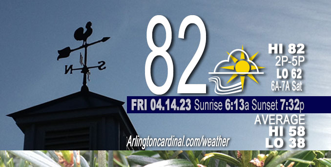
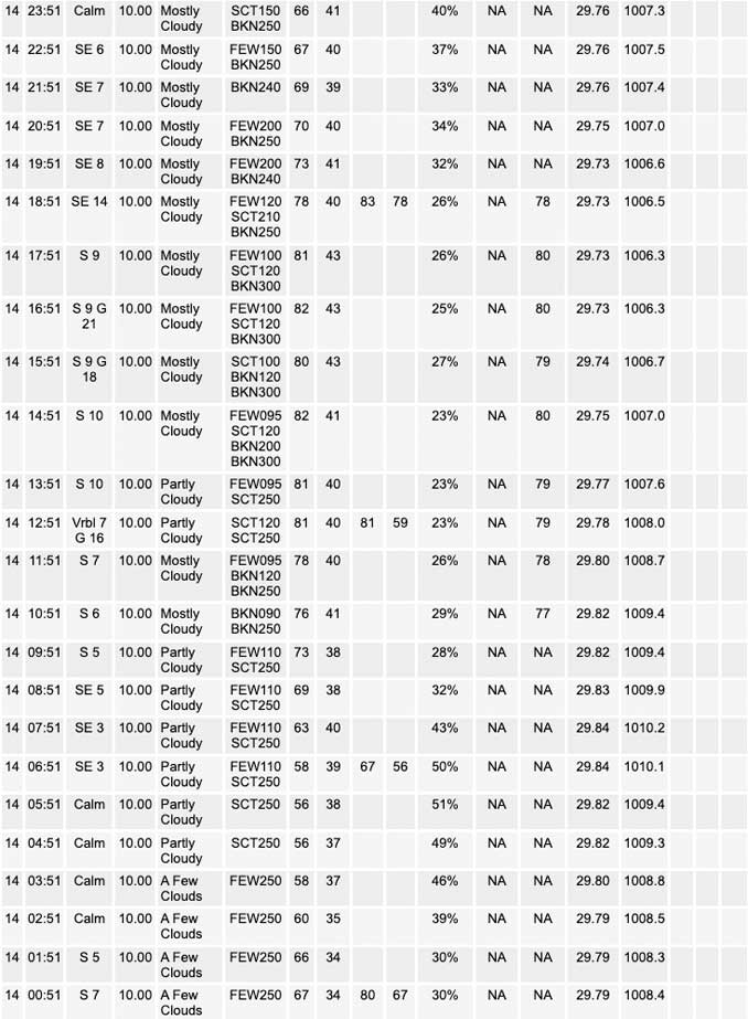
Friday Hi 82, partly cloudy, winds SE to S to SE, 3 to 14 to 5 MPH, G18 to 21 MPH, 3p to 5p

NWS CHGO | NWS HRLY | /NWSchicago | 🌡
ARLINGTON HEIGHTS WEATHER
▴ forecast7 (Arl. Hts.) | RADAR | WIDE RADAR
⏪ Hrly Data Table | Hrly Future Graph ⏩
IMPORTANT NOTE ON NWS DATA
⏪ Hrly Data Table | Hrly Future Graph ⏩
Hello mobile users! If you encounter a mobile “unfriendly” weather page, turn your phone sideways for a better view.
======================
Friday and Friday Evening …
No Weather Hazards expected …
UPDATE: Chicago (at O’Hare) set a new record high temperature of 83° on Thursday, April 13, 2023. The previous record high for April 13th was 82°, set in 1887 and tied in 1941.
DISCUSSION…
Another unseasonably warm day is in store today with high temperatures in the low 80s.
======================
O’HARE FORECAST …
Forecast Beginning Friday, Apr. 14, 2023
Friday: Partly sunny, with a high near 83. East southeast wind around 10 mph, with gusts as high as 15 mph.
Friday Night: Mostly cloudy, with a low around 62. East southeast wind 5 to 10 mph becoming south southwest after midnight.
Saturday: Partly sunny, with a high near 80. South wind 5 to 15 mph, with gusts as high as 20 mph.
Saturday Night: A chance of showers and thunderstorms, then showers and possibly a thunderstorm after 10pm. Low around 61. South wind 10 to 15 mph, with gusts as high as 25 mph. Chance of precipitation is 80%.
Sunday: Showers and possibly a thunderstorm. High near 63. Breezy, with a south wind 10 to 20 mph, with gusts as high as 30 mph. Chance of precipitation is 80%.
Sunday Night: Rain likely before 4am, then rain likely, possibly mixed with snow. Mostly cloudy, with a low around 36. Breezy. Chance of precipitation is 70%.
Monday: A chance of rain and snow before 1pm, then a chance of rain. Cloudy, with a high near 45. Breezy. Chance of precipitation is 50%.
Monday Night: Partly cloudy, with a low around 33. Breezy.
Tuesday: Sunny, with a high near 54.
Tuesday Night: Partly cloudy, with a low around 42.
Wednesday: Partly sunny, with a high near 68.
Wednesday Night: A chance of showers. Mostly cloudy, with a low around 55.
Thursday: A chance of showers. Mostly cloudy, with a high near 71.


CHICAGOWEATHERSTATION.COM
ChicagoWeatherStation.com I O’Hare Normal Temps/Precip I O’Hare Record Temps, Precip, Snow
WunderMap® with Temperature/Wind Data || Google: Arlington Heights Area Temps | US TEMPS
Midwest Cloud Cover with Arlington Heights Weather Forecast
ChicagoWeatherStation.com I O’Hare Normal Temps/Precip I O’Hare Record Temps, Precip, Snow
SUNLIGHT DATA FOR SECURITY, TRAFFIC SAFETY, AND SPORTS
SunCalc.net data with solar azimuth and trajectory, times for dawn, sunrise, solar noon, sunset, dusk …
NIGHT SKY THIS MONTH …
Backyard stargazers get a monthly guide to the northern hemisphere’s skywatching events with “Tonight’s Sky.” Check the night sky objects for this month and past months in the playlist from the Space Telescope Science Institute YouTube channel (Musical track The Far River written by Jonn Serrie, from the album And the Stars Go With You courtesy of New World Music Ltd).
Get updates from The Cardinal ALL NEWS FEEDS on Facebook. Just ‘LIKE’ the ‘Arlington Cardinal Page (become a fan of our page). The updates cover all posts and sub-category posts from The Cardinal — Arlingtoncardinal.com. You can also limit feeds to specific categories. See all of The Cardinal Facebook fan pages at Arlingtoncardinal.com/about/facebook …
Help fund The Cardinal Arlingtoncardinal.com/sponsor
/////////////>
Area Forecast Discussion
National Weather Service Chicago/Romeoville, IL
627 AM CDT Fri Apr 14 2023
.SHORT TERM… Issued at 314 AM CDT Fri Apr 14 2023
Through Saturday…
Another unseasonably warm day is in store today with high temperatures in the low 80s. While conditions will remain quite dry today, low-level moisture trends will become a bit more muddled as the day progresses. A compact low that lifted north from the Gulf of Mexico will advect a stream of Atlantic-sourced low-level moisture into the Ohio River Valley (a rather uncommon trajectory this far north and west outside of tropical systems). A gradual increase in mid-level clouds ahead of the low should slightly reduce mixing heights while low-level moistening limits the reservoir for drier air to mix to the surface. If the increase in moisture is more pronounced than currently expected, forecast RH values around the mid 20s may end up being too low. In fact, min RH values from guidance today produces a nearly 20% range from the low 20s to around 40%. While winds will be slightly lower than Thursday, some gusts over 20 mph, especially in the northwest CWA, will favor continued elevated fire spread concerns this afternoon.
By Saturday morning, additional low-level moisture from the Gulf of Mexico will begin filtering into the area, reducing the elevated/high fire risk from the past few days. Low/mid-level warming from an EML will cap the forecast area through most of the daytime hours, but with mid-level height falls beginning to spread over the area ahead of an approaching trough late in the day, an isolated storm or two may develop across the western CWA prior to sunset.
Kluber/NWS Chicago


