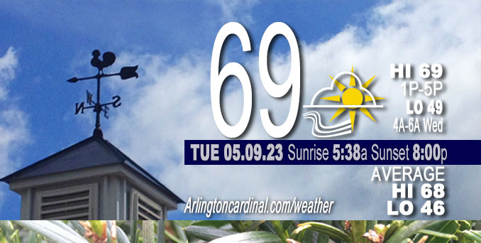
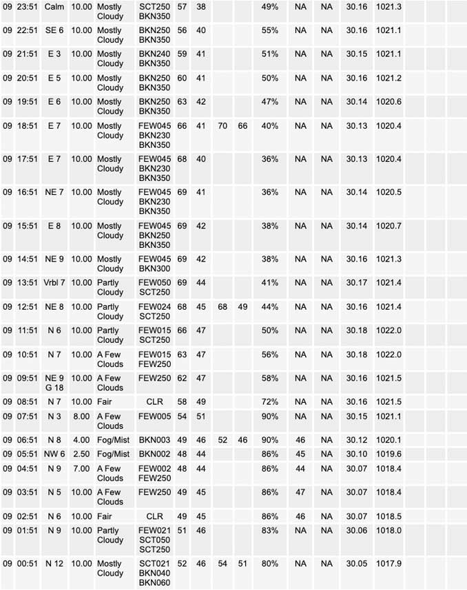
Tuesday Hi 69, partly cloudy to mostly cloudy, winds N to NE to E, 3 to 9 to 3 MPH, G18 MPH, 9a to 10a

NWS CHGO | NWS HRLY | /NWSchicago | 🌡
ARLINGTON HEIGHTS WEATHER
▴ forecast7 (Arl. Hts.) | RADAR | WIDE RADAR
⏪ Hrly Data Table | Hrly Future Graph ⏩
IMPORTANT NOTE ON NWS DATA
⏪ Hrly Data Table | Hrly Future Graph ⏩
Hello mobile users! If you encounter a mobile “unfriendly” weather page, turn your phone sideways for a better view.
======================
Tuesday and Tuesday Evening …
Weather Hazards expected …
Fog risk.
DISCUSSION…
Any inland fog will mix out readily this morning while marine fog may linger into the afternoon.
======================
O’HARE FORECAST …
Forecast Beginning Tuesday, May 09, 2023
Tuesday: Mostly sunny, with a high near 68. East northeast wind 5 to 10 mph, with gusts as high as 15 mph.
Tuesday Night: Mostly clear, with a low around 48. East wind around 5 mph becoming calm in the evening.
Wednesday: Sunny, with a high near 78. Light and variable wind becoming southeast 5 to 10 mph in the morning. Winds could gust as high as 15 mph.
Wednesday Night: Partly cloudy, with a low around 54. South southeast wind 5 to 10 mph.
Thursday: Mostly sunny, with a high near 80. South southeast wind 5 to 10 mph.
Thursday Night: A slight chance of showers before 1am, then a chance of showers and thunderstorms between 1am and 4am, then a chance of showers after 4am. Mostly cloudy, with a low around 61. Chance of precipitation is 30%.
Friday: Showers likely, with thunderstorms also possible after 1pm. Mostly cloudy, with a high near 77. Chance of precipitation is 70%.
Friday Night: Showers likely. Mostly cloudy, with a low around 61.
Saturday: A chance of showers. Mostly cloudy, with a high near 75.
Saturday Night: A chance of showers. Mostly cloudy, with a low around 56.
Sunday: A chance of showers. Mostly cloudy, with a high near 66.
Sunday Night: Mostly cloudy, with a low around 48.
Monday: Mostly sunny, with a high near 71.


CHICAGOWEATHERSTATION.COM
ChicagoWeatherStation.com I O’Hare Normal Temps/Precip I O’Hare Record Temps, Precip, Snow
WunderMap® with Temperature/Wind Data || Google: Arlington Heights Area Temps | US TEMPS
Midwest Cloud Cover with Arlington Heights Weather Forecast
ChicagoWeatherStation.com I O’Hare Normal Temps/Precip I O’Hare Record Temps, Precip, Snow
SUNLIGHT DATA FOR SECURITY, TRAFFIC SAFETY, AND SPORTS
SunCalc.net data with solar azimuth and trajectory, times for dawn, sunrise, solar noon, sunset, dusk …
NIGHT SKY THIS MONTH …
Backyard stargazers get a monthly guide to the northern hemisphere’s skywatching events with “Tonight’s Sky.” Check the night sky objects for this month and past months in the playlist from the Space Telescope Science Institute YouTube channel (Musical track The Far River written by Jonn Serrie, from the album And the Stars Go With You courtesy of New World Music Ltd).
Get updates from The Cardinal ALL NEWS FEEDS on Facebook. Just ‘LIKE’ the ‘Arlington Cardinal Page (become a fan of our page). The updates cover all posts and sub-category posts from The Cardinal — Arlingtoncardinal.com. You can also limit feeds to specific categories. See all of The Cardinal Facebook fan pages at Arlingtoncardinal.com/about/facebook …
Help fund The Cardinal Arlingtoncardinal.com/sponsor
/////////////>
Area Forecast Discussion
National Weather Service Chicago/Romeoville, IL
620 AM CDT Tue May 9 2023
.SHORT TERM… Issued at 213 AM CDT Tue May 9 2023
Through Wednesday…
Much quieter in the short term with high pressure set to dominate the local weather scene. The only concern today revolves around the dense fog potential through mid morning. Lots of holes within the low stratus deck noted in nighttime microphysics RGB imagery, and with dewpoint depressions running less than 2-3 F in most locations with very light flow in place, the potential for an expanding region of dense fog is on the table. The worst conditions are expanding southward out of SE Wisconsin and this probably will continue into parts of NE Illinois. Dense marine fog is also oozing southward, with it possible this will fill in across the southwestern part of the lake through sunrise. Suspect that things away from the lake may remain more on the patchy or patchy dense side. Will be keeping an eye on trends over the next few hours with fog headlines possible, with Lake County (IL) likely the first up.
Any inland fog will mix out readily this morning while marine fog may linger into the afternoon. Have boosted high temperature a smidge away from the lake. Temperatures on Wednesday look to take a 4-8 degree jump (again away from the lake), with a smattering of 80-degree readings not out of the question. Weak gradient flow will again set up favorable conditions for lake cooling with an afternoon lake breeze.
Carlaw/NWS Chicago


