
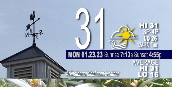
Monday Hi 31, cloudy to partly sunny, winds WNW to W to SW to WSW, 7 to 20 to 10 MPH, G14 to 29 to 26 MPH through Tuesday
NWS CHGO | NWS HRLY | /NWSchicago | 🌡
ARLINGTON HEIGHTS WEATHER
▴ forecast7 (Arl. Hts.) | RADAR | WIDE RADAR
⏪ Hrly Data Table | Hrly Future Graph ⏩
IMPORTANT NOTE ON NWS DATA
⏪ Hrly Data Table | Hrly Future Graph ⏩
======================
Monday and Monday Night …
No Weather Hazards expected …
Patchy mix of freezing drizzle and light snow…
DISCUSSION…
Patches of freezing drizzle and light snow will continue to move east into parts of northwest Indiana this morning. This includes portions of I-65, I-80, I-90, and I-94. Be aware of isolated slick spots, primarily on untreated surfaces, secondary roads and elevated surfaces such as bridges and overpasses this morning.
Less than one week left of the normal daily low temperature bottomed out at 16°F. Daily high increases from 31°F to 32°F in eight days. We’re gaining about 2 minutes of daylight every day in the progression toward vernal equinox, March 20, 2023.
======================
O’HARE FORECAST …
Forecast Beginning Monday, Jan. 23, 2023
Monday: Cloudy, with a high near 31. Breezy, with a west southwest wind 5 to 10 mph increasing to 15 to 20 mph in the afternoon. Winds could gust as high as 25 mph.
Monday Night: Mostly cloudy, with a low around 26. Breezy, with a west wind 15 to 20 mph decreasing to 10 to 15 mph after midnight. Winds could gust as high as 30 mph.
Tuesday: Mostly cloudy, with a high near 33. West wind 5 to 10 mph becoming south southwest in the afternoon. Winds could gust as high as 15 mph.
Tuesday Night: A 30 percent chance of snow after midnight. Cloudy, with a low around 30. South wind 5 to 10 mph becoming east northeast after midnight.
Wednesday: Snow. High near 34. East northeast wind 10 to 15 mph becoming north in the afternoon. Winds could gust as high as 25 mph. Chance of precipitation is 90%.
Wednesday Night: A 50 percent chance of snow showers, mainly before midnight. Cloudy, with a low around 27.
Thursday: A 20 percent chance of snow showers. Cloudy, with a high near 30.
Thursday Night: Mostly cloudy, with a low around 19.
Friday: A chance of snow showers after noon. Cloudy, with a high near 34.
Friday Night: Mostly cloudy, with a low around 22.
Saturday: Mostly cloudy, with a high near 29.
Saturday Night: A chance of snow. Cloudy, with a low around 19.
Sunday: A chance of snow. Cloudy, with a high near 27.


CHICAGOWEATHERSTATION.COM

ChicagoWeatherStation.com I O’Hare Normal Temps/Precip I O’Hare Record Temps, Precip, Snow
LIVE RADAR | STORM TRACKS | UNISYS US IR SAT | UNISYS Midwest IR SAT | UNISYS More IR SAT
WunderMap® with Temperature/Wind Data || Google: Arlington Heights Area Temps | US TEMPS
Full Screen Motion Weather Radar (Wunderground.com)
Midwest Cloud Cover with Arlington Heights Weather Forecast
ChicagoWeatherStation.com I O’Hare Normal Temps/Precip I O’Hare Record Temps, Precip, Snow
SUNLIGHT DATA FOR SECURITY, TRAFFIC SAFETY, AND SPORTS
SunCalc.net data with solar azimuth and trajectory, times for dawn, sunrise, solar noon, sunset, dusk …
NIGHT SKY THIS MONTH …
Backyard stargazers get a monthly guide to the northern hemisphere’s skywatching events with “Tonight’s Sky.” Check the night sky objects for this month and past months in the playlist from the Space Telescope Science Institute YouTube channel (Musical track The Far River written by Jonn Serrie, from the album And the Stars Go With You courtesy of New World Music Ltd).
Get updates from The Cardinal ALL NEWS FEEDS on Facebook. Just ‘LIKE’ the ‘Arlington Cardinal Page (become a fan of our page). The updates cover all posts and sub-category posts from The Cardinal — Arlingtoncardinal.com. You can also limit feeds to specific categories. See all of The Cardinal Facebook fan pages at Arlingtoncardinal.com/about/facebook …
Help fund The Cardinal Arlingtoncardinal.com/sponsor
Area Forecast Discussion
National Weather Service Chicago/Romeoville, IL
527 AM CST Mon Jan 23 2023
.SHORT TERM… Issued at 305 AM CST Mon Jan 23 2023
Through Tuesday…
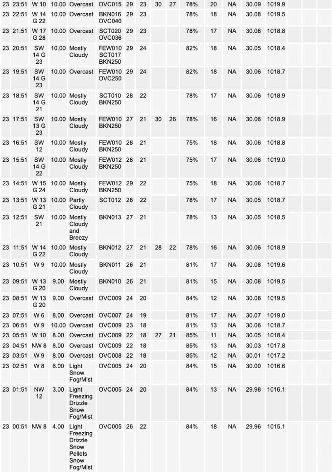
The light snow showers/heavier flurries that had been falling on much of the Chicago metro late last night have fizzled away just over the past couple of hours. Recently, we`ve seen dewpoints drop off above 900mb as the mid level vort max progresses eastward with the trough and takes a good deal of low level moisture with it. RAP soundings suggest we will continue to lose out on low level moisture especially over these next couple of hours (2-4 AM timeframe). But for now, it looks like we`re hanging onto just enough moisture to support light flurries and freezing drizzle mainly east of a Kane-Kendall-Grundy County line. However, it (hopefully) shouldn`t take long before we`re simply too dry to support precip in any fashion. Nonetheless, a few isolated slick spots will likely be hanging around into the Monday morning commute across untreated, secondary roads and elevated surfaces such as bridges and overpasses.
Meanwhile, temperatures across the area early this morning are hanging out in the 20s and dropping very slowly thanks to the low stratus overhead. The big question heading into the day is whether we`ll manage to sneak in some sunshine and how sky conditions will influence our temperatures through the day. With high pressure working its way in from the northwest, the synoptic subsidence will dry out the majority our profile while also strengthening the low level inversion already in place. So if we are able to depart from our dewpoints underneath the inversion, we will scatter out the cloud cover and work in some good sunshine. Models that play into this solution, such as the GFS and NAM, pull temperatures into the lower and middle 30s for this afternoon. The other option is that too much moisture gets trapped under the inversion keeping a thin overcast hanging around. The RAP and HRRR, which favor a cloudy day, restrict afternoon highs to the middle 20s to near 30 degrees. As nice as the vitamin D sounds, I decided to be pessimistic and side with the cloudy solution for two primary reasons: the first being that the models that scatter us out look to downplay the strength of the inversion in the wake of the subsidence aloft. Next, veering winds through the low levels today suggest warm air advection and favor a higher moisture content under the inversion, something I`m worried the GFS and NAM may be neglecting.
In other news, the short term looks to be mostly dry following the light precip out there currently. One possible exception is late tonight into Tuesday morning when a few models are tossing up some light QPF. A weak cold front will moving across the upper Great Lakes during this time. This front sort of fizzles away before extending this far south and instead translates to, at most, a broad surface trough. Most high res guidance resolves some modest low level omega in the wake of the surface trough and some enhanced flow aloft. The RAP and HRRR are also showing the slightest bit of low level upright instability. So it`s not so much the forcing that has me skeptical. Moreso, it`s our low level moisture content. While some saturation is likely underneath the inversion, it simply looks too shallow on forecast soundings to support any precip development even given the potential for some meager forcing. Therefore, the forecast for this period was kept dry for now. If we did manage to squeeze out some precip, it would more than likely be in the form of freezing drizzle with a dry profile above -10C keeping cloud ice scarce if not absent.
Doom/NWS Chicago
