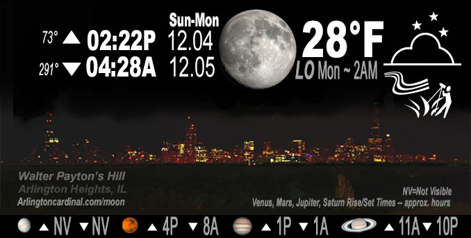
🌔 🌕 🌗 🌑 Waxing Gibbous Moon, sky cover overnight Sun. to Mon. 2% to 88%, winds SW, 10 to 9 MPH, G17 to 14 to 15 MPH, Low 28, 2a to 5a

NWS CHGO | NWS HRLY | /NWSchicago | 🌡
ARLINGTON HEIGHTS WEATHER
▴ forecast7 (Arl. Hts.) | RADAR | WIDE RADAR
IMPORTANT NOTE ON NWS DATA
======================
Overnight Sunday/Monday …
No Weather Hazards expected…
DISCUSSION…
Thin cirrus will begin drifting over the area from the west toward sunset, but likely will not be thick enough to prevent rapid decoupling in this existing dry airmass. Temps should quickly fall into the mid 20s inland within the first few hours after sunset, then slowly lower or even level off by late evening as upper-cloud cover increases.
Hello mobile users! If you encounter mobile “unfriendly” weather page, turn your phone sideways for a better view.
======================
O’HARE FORECAST …
Forecast Beginning Sunday Night, Dec. 4, 2022
Sunday Night: Increasing clouds, with a low around 28. Southwest wind around 10 mph, with gusts as high as 15 mph.
Monday: Mostly cloudy, with a high near 44. South southwest wind around 10 mph, with gusts as high as 20 mph.
Monday Night: Mostly cloudy, with a low around 30. South southwest wind 5 to 10 mph becoming north after midnight.
Tuesday: A 20 percent chance of rain after noon. Mostly cloudy, with a high near 42. Northeast wind 5 to 10 mph, with gusts as high as 15 mph.
Tuesday Night: A 30 percent chance of rain, mainly before midnight. Mostly cloudy, with a low around 32.
Wednesday: Partly sunny, with a high near 44.
Wednesday Night: Mostly cloudy, with a low around 34.
Thursday: A chance of rain. Mostly cloudy, with a high near 43.
Thursday Night: A chance of rain. Mostly cloudy, with a low around 34.
Friday: Mostly cloudy, with a high near 41.
Friday Night: Mostly cloudy, with a low around 31.
Saturday: A chance of rain. Partly sunny, with a high near 41.
O’Hare forecast archive and hourly weather observations archive are available HERE on the CARDINAL NEWS Magazine.
Arlingtoncardinal.com/moonphases
Arlingtoncardinal.com/nightsky
NIGHT SKY THIS MONTH …
Check the night sky objects for this month and past months in the playlist from the Space Telescope Science Institute YouTube channel Backyard stargazers get a monthly guide to the northern hemisphere’s skywatching events with “Tonight’s Sky” (Musical track The Far River written by Jonn Serrie, from the album And the Stars Go With You courtesy of New World Music Ltd. Musical track The Far River written by Jonn Serrie, from the album And the Stars Go With You courtesy of New World Music Ltd).
Telephoto lens, ISO 100, f/11, Shutter Speed 1/100 to 1/125 for the Moon.
Get updates from The Cardinal ALL NEWS FEEDS on Facebook. Just ‘LIKE’ the ‘Arlington Cardinal Page (become a fan of our page). The updates cover all posts and sub-category posts from The Cardinal — Arlingtoncardinal.com. You can also limit feeds to specific categories. See all of The Cardinal Facebook fan pages at Arlingtoncardinal.com/about/facebook …
Help fund The Cardinal Arlingtoncardinal.com/sponsor
Telephoto lens, ISO 1600, f/11, Shutter Speed 2.5″ for the skyline. The skyline exposure was toned down, and brightness and contrast was adjusted in Photoshop.
Area Forecast Discussion
National Weather Service Chicago/Romeoville, IL
1116 PM CST Sun Dec 4 2022
.SHORT TERM…
Issued at 148 PM CST Sun Dec 4 2022
Through Monday night…
Thin cirrus will begin drifting over the area from the west toward sunset, but likely will not be thick enough to prevent rapid decoupling in this existing dry airmass. Temps should quickly fall into the mid 20s inland within the first few hours after sunset, then slowly lower or even level off by late evening as upper-cloud cover increases. A 35kt low-level wind max as low as 1kft AGL late evening into the overnight hours may result in some sporadic gusts to 20 mph, especially if near surface stability is reduced by the thickening clouds.
A low-amplitude wave in general WSW flow aloft will shift through central Wisconsin Monday morning. While some increased mid-level clouds are likely across northern Illinois, limited depth to the mid- level moisture and a very dry sub-cloud layer will preclude precip chances with this wave.
Higher low-level moisture currently as far north as southern Missouri will begin advecting northeast this evening as southwest flow increases. Obs and model trends suggest this moisture should at least spread across areas southeast of I-55 by late Monday afternoon. Isentropic ascent over the area may begin waning prior to the arrival of the low-level moisture, but lingering low-level ascent should still provide sufficient ascent within a marginally deep saturated layer to generate spotty light rain or drizzle late afternoon into the evening.
A quick-moving low passing north of Lake Superior tonight will drag a cold front SSE across the area late Monday evening, clearing out any remaining pre-frontal precip across east-central IL and northwest IN.
Kluber/NWS Chicago

