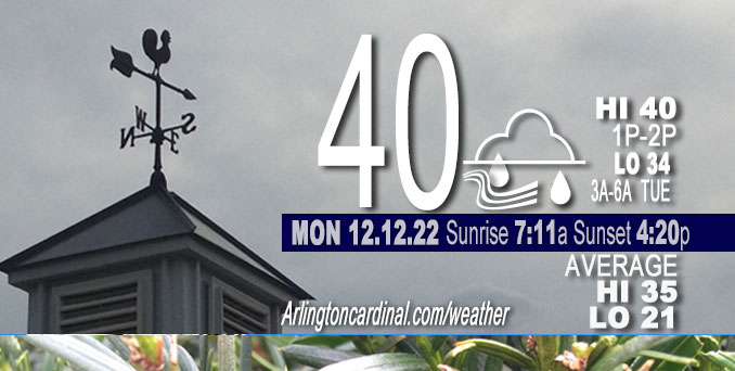
MONDAY Hi 40, mostly cloudy, chance drizzle until 11a, winds NE to E to SE, 6 to 10 MPH, G13 to 17 MPH, 3p increasing through 12a

NWS CHGO | NWS HRLY | /NWSchicago | 🌡
ARLINGTON HEIGHTS WEATHER
▴ forecast7 (Arl. Hts.) | RADAR | WIDE RADAR
⏪ Hrly Data Table | Hrly Future Graph ⏩
IMPORTANT NOTE ON NWS DATA
⏪ Hrly Data Table | Hrly Future Graph ⏩
======================
Monday and Monday Night …
No Weather Hazards expected…
In the 7-day outlook, there is no forecast below freezing until early Friday morning (Dec. 16, 2022).
DISCUSSION…
Subsidence Inversion continues to keep low-level moisture and an expansive stratus/stratocumulus deck over Chicagoland. An inverted surface
trough from over Lake Michigan has begun to swoop inland, and patchy drizzle is reported around Chicagoland. Inverted surface
troughs can happen when there is high pressure to the north, and there is a large high pressure area in eastern Canada. There might even be a rain shower until about 11:00 a.m. There could be some thinning of clouds compared to the previous several days, but mostly cloudy skies persist in the forecast through Sunday.
Snow is possible Thursday night and Friday, but currently it only looks like it will accumulate to about 0.5 inch.
Hello mobile users! If you encounter a mobile “unfriendly” weather page, turn your phone sideways for a better view.
======================
O’HARE FORECAST …
Forecast Beginning Monday, Dec. 12, 2022
Monday: A 20 percent chance of drizzle with a slight chance of rain before 1pm. Cloudy, with a high near 40. East wind 5 to 10 mph.
Monday Night: Mostly cloudy, with a low around 34. East southeast wind around 10 mph, with gusts as high as 20 mph.
Tuesday: Mostly cloudy, with a high near 41. Breezy, with an east southeast wind 10 to 15 mph increasing to 15 to 20 mph in the afternoon. Winds could gust as high as 30 mph.
Tuesday Night: Rain, mainly after 1am. Low around 38. Breezy, with an east southeast wind around 20 mph, with gusts as high as 35 mph. Chance of precipitation is 90%.
Wednesday: Rain. High near 48. Breezy, with a southeast wind 15 to 20 mph, with gusts as high as 35 mph. Chance of precipitation is 90%.
Wednesday Night: Rain likely. Mostly cloudy, with a low around 38. Chance of precipitation is 70%.
Thursday: Rain likely, mainly before 7am. Mostly cloudy, with a high near 42. Chance of precipitation is 60%.
Thursday Night: A chance of rain before 7pm, then a chance of rain and snow between 7pm and 1am, then a chance of snow after 1am. Cloudy, with a low around 31.
Friday: Snow likely, mainly after 1pm. Cloudy, with a high near 36.
Friday Night: Snow likely, mainly before 7pm. Cloudy, with a low around 23.
Saturday: Mostly cloudy, with a high near 28.
Saturday Night: Mostly cloudy, with a low around 19.
Sunday: Mostly cloudy, with a high near 28.


CHICAGOWEATHERSTATION.COM
ChicagoWeatherStation.com I O’Hare Normal Temps/Precip I O’Hare Record Temps, Precip, Snow
LIVE RADAR | STORM TRACKS | UNISYS US IR SAT | UNISYS Midwest IR SAT | UNISYS More IR SAT
WunderMap® with Temperature/Wind Data || Google: Arlington Heights Area Temps | US TEMPS
Full Screen Motion Weather Radar (Wunderground.com)
Midwest Cloud Cover with Arlington Heights Weather Forecast
ChicagoWeatherStation.com I O’Hare Normal Temps/Precip I O’Hare Record Temps, Precip, Snow
SUNLIGHT DATA FOR SECURITY, TRAFFIC SAFETY, AND SPORTS
SunCalc.net data with solar azimuth and trajectory, times for dawn, sunrise, solar noon, sunset, dusk …
NIGHT SKY THIS MONTH …
Backyard stargazers get a monthly guide to the northern hemisphere’s skywatching events with “Tonight’s Sky.” Check the night sky objects for this month and past months in the playlist from the Space Telescope Science Institute YouTube channel (Musical track The Far River written by Jonn Serrie, from the album And the Stars Go With You courtesy of New World Music Ltd).
Get updates from The Cardinal ALL NEWS FEEDS on Facebook. Just ‘LIKE’ the ‘Arlington Cardinal Page (become a fan of our page). The updates cover all posts and sub-category posts from The Cardinal — Arlingtoncardinal.com. You can also limit feeds to specific categories. See all of The Cardinal Facebook fan pages at Arlingtoncardinal.com/about/facebook …
Help fund The Cardinal Arlingtoncardinal.com/sponsor
Area Forecast Discussion
National Weather Service Chicago/Romeoville, IL
513 AM CST Mon Dec 12 2022
.SHORT TERM… Issued at 326 AM CST Mon Dec 12 2022
Through Tuesday…
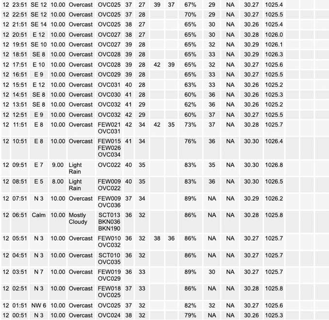
We will remain mired in the doldrums of December for yet another day today as an ever-present subsidence inversion continues to keep low- level moisture, manifested as an expansive stratus/stratocumulus deck, locked beneath it. Drizzle is already ongoing early this morning in some parts of the Chicago metro as an inverted surface trough from over Lake Michigan has begun to swoop inland. The expectation is that at least patchy drizzle (and perhaps a bonafide rain shower or two) will likely continue across parts of the metro through the remainder of this morning, and potentially even into the early afternoon, before ceasing as cloud depths shrink gradually with time. Some guidance actually suggests that some peeks of sunshine could be seen somewhere in our forecast area later this afternoon as the low cloud deck thins out, but given how things have been the past few days, there are reasons to be skeptical that that will actually be the case. Temperatures won`t climb much higher than this morning`s lows once again as solar insolation remains inhibited by the opaque low clouds and no appreciable thermal advection is expected. Fortunately, temperatures are, and are expected to remain, above freezing today, so not anticipating any freezing drizzle concerns.
Low clouds will likely continue to plague the area again as we head into Tuesday (shocker!), and consequently, Tuesday`s highs look like they`ll be nearly identical to today`s (likely within a couple of degrees of 40F). However, there will be at least one noticeable difference in Tuesday`s weather from previous days in that it will be much breezier with east-southeasterly winds expected to start gusting in excess of 30 mph by the mid/late afternoon as a rapidly deepening and occluding low pressure system over the Great Plains compresses pressure gradients across the region and we begin mixing into the bottom of a stout low-level jet. Rain associated with this system could start making inroads to our westernmost counties come the late afternoon, but there is fairly good agreement amongst forecast guidance that the bulk of the precipitation likely won`t arrive here until after sunset. For more information on this system and the precipitation it will bring, reference the long term discussion below.
Ogorek/NWS Chicago


