
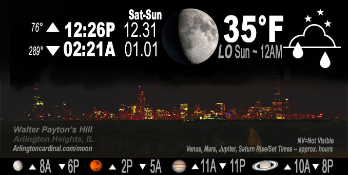
🌔 🌕 🌗 🌑 Waxing Gibbous Moon, sky cover overnight Sat. to Sun. 77% to 92% to 77%, winds SSW to SE to SW, 5 to 7 MPH, Low 35, 12a to 1a
NWS CHGO | NWS HRLY | /NWSchicago | 🌡
ARLINGTON HEIGHTS WEATHER
▴ forecast7 (Arl. Hts.) | RADAR | WIDE RADAR
IMPORTANT NOTE ON NWS DATA
======================
NIGHT FORECASTS …
NOTE 1: Forecast and information text below may refer to a previous night on Arlingtoncardinal.com, and might not be updated until late afternoon, evening, or overnight. However, Night Sky archives on CARDINAL NEWS Magazine include text forecasts that correspond to the lunar phase graphic above.
NOTE 2: Keep in mind lunar rise and set times don’t always correspond with night weather and early morning lows because on some days during the month the moon is visible in the sky predominantly during the daytime hours.
Overnight Saturday/Sunday …
Weather Hazards expected …
Limited Fog Risk overnight toward morning.
DISCUSSION…
Areas of fog are expected to develop overnight and last into Sunday morning. A few patches of dense fog are possible.
Hello mobile users! If you encounter mobile “unfriendly” weather page, turn your phone sideways for a better view.
======================
O’HARE FORECAST …
Forecast Beginning Saturday Night, Dec. 31, 2022 …
Saturday Night: Rain, mainly before 4am. Patchy fog after 4am. Low around 35. South southeast wind around 5 mph. Chance of precipitation is 80%. New precipitation amounts between a tenth and quarter of an inch possible.
New Year’s Day: Patchy fog before 11am. Otherwise, mostly cloudy, with a high near 47. West wind around 5 mph.
Sunday Night: Cloudy, with a low around 35. West wind around 5 mph becoming calm in the evening.
Monday: A 20 percent chance of rain after noon. Cloudy, with a high near 45. East wind around 5 mph, with gusts as high as 15 mph.
Monday Night: Rain, with thunderstorms also possible after 9pm. Low around 43. East wind 5 to 10 mph becoming south after midnight. Winds could gust as high as 20 mph. Chance of precipitation is 90%.
Tuesday: A 40 percent chance of rain, mainly before noon. Partly sunny, with a high near 58.
Tuesday Night: Mostly cloudy, with a low around 32.
Wednesday: A chance of snow after noon. Mostly cloudy, with a high near 37.
Wednesday Night: Mostly cloudy, with a low around 27.
Thursday: Mostly cloudy, with a high near 33.
Thursday Night: Partly cloudy, with a low around 23.
Friday: Mostly sunny, with a high near 35.
Friday Night: Mostly cloudy, with a low around 28.
Saturday: Mostly cloudy, with a high near 39.
O’Hare forecast archive and hourly weather observations archive are available HERE on the CARDINAL NEWS Magazine.
Arlingtoncardinal.com/moonphases
Arlingtoncardinal.com/nightsky
NIGHT SKY THIS MONTH …
Check the night sky objects for this month and past months in the playlist from the Space Telescope Science Institute YouTube channel Backyard stargazers get a monthly guide to the northern hemisphere’s skywatching events with “Tonight’s Sky” (Musical track The Far River written by Jonn Serrie, from the album And the Stars Go With You courtesy of New World Music Ltd. Musical track The Far River written by Jonn Serrie, from the album And the Stars Go With You courtesy of New World Music Ltd).
Telephoto lens, ISO 100, f/11, Shutter Speed 1/100 to 1/125 for the Moon.
Get updates from The Cardinal ALL NEWS FEEDS on Facebook. Just ‘LIKE’ the ‘Arlington Cardinal Page (become a fan of our page). The updates cover all posts and sub-category posts from The Cardinal — Arlingtoncardinal.com. You can also limit feeds to specific categories. See all of The Cardinal Facebook fan pages at Arlingtoncardinal.com/about/facebook …
Help fund The Cardinal Arlingtoncardinal.com/sponsor
Telephoto lens, ISO 1600, f/11, Shutter Speed 2.5″ for the skyline. The skyline exposure was toned down, and brightness and contrast was adjusted in Photoshop.
Area Forecast Discussion
National Weather Service Chicago/Romeoville, IL
1135 PM CST Sat Dec 31 2022
.UPDATE… Issued at 824 PM CST Sat Dec 31 2022
No significant changes to going forecast this evening. Primary concern continues to be a period of mixed rain/snow/freezing rain this evening from the I-39 corridor east-northeast through the northern Chicago metro suburbs before low level temps and wet bulbs warm solidly above freezing. Did raise pops a bit across the north and made some temp/dew point and wet bulb adjustments based on near term obs trends, but otherwise forecast appears to be in good shape.
Have seen some spotty light precipitation early this evening mainly along/north of about a Sterling to Waukegan line. Surface temps were generally in the 32-35 degree range in this area per ASOS/AWOS and private sensors, with RAP soundings depicting sub- freezing wet-bulb profiles below cloud base. This will likely support a brief period of mixed rain/snow and perhaps even a few sleet pellets as precipitation continues to increase in coverage over the next couple of hours. Persistent low level warm advection will gradually warm surface temperatures and dew points solidly above freezing by midnight, with gradual low level saturation working to increase wet bulbs and turn precip to all by midnight. Some patchy slick spots are possible mainly on thinner untreated surfaces such as sidewalks and parking lots this evening however.
This precipitation is associated with a pair of mid-level short waves traversing the region. The first, currently transiting WI, largely worked to saturate the mid-levels. The second and stronger wave currently crossing the mid-upper Missouri Valley will bring stronger forcing across the region overnight, expanding rain over the forecast area toward/after midnight. The wave will exit the region prior to sunrise allowing rain to exit to the east early Sunday morning. Lingering low clouds and patchy fog will likely linger into the daytime hours however.
Updated digital and text forecasts available.
Ratzer/NWS Chicago
