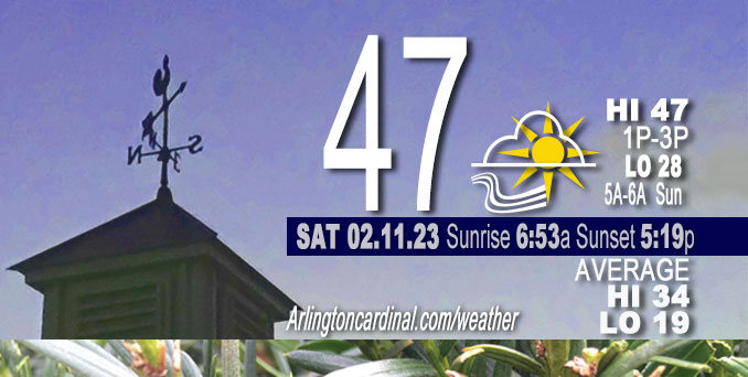
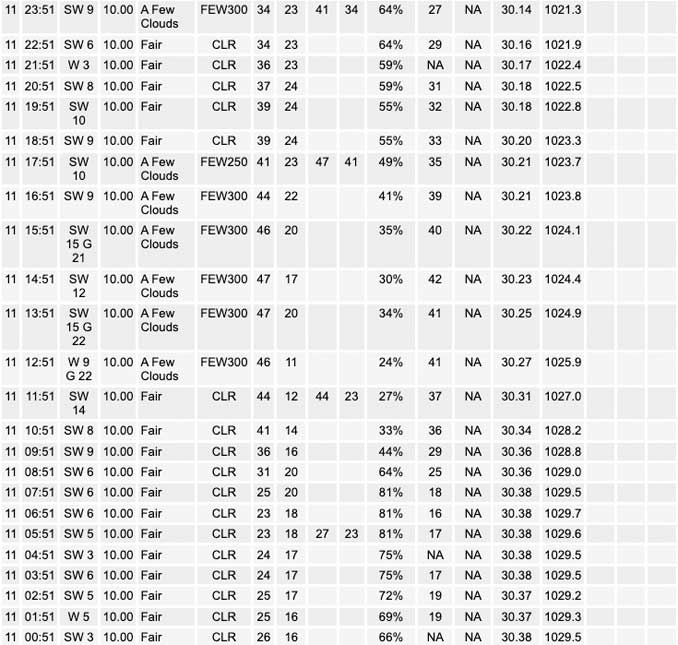
Saturday Hi 47, Sunny, winds SW, 6 to 15 to 7 MPH, G14 to 22 to 14 MPH ending 6p

NWS CHGO | NWS HRLY | /NWSchicago | 🌡
ARLINGTON HEIGHTS WEATHER
▴ forecast7 (Arl. Hts.) | RADAR | WIDE RADAR
⏪ Hrly Data Table | Hrly Future Graph ⏩
IMPORTANT NOTE ON NWS DATA
⏪ Hrly Data Table | Hrly Future Graph ⏩
======================
Saturday and Saturday Night …
No Weather Hazards expected …
Above normal temperatures but gusty winds from the southwest around 15 to 20 MPH ending about 6:00 p.m. Saturday.
DISCUSSION…
An elongated surface ridge will settle in across central Illinois Saturday while a surface low pressure system whose center was analyzed over Lake Winnipeg around 5:30 a.m. Saturday will race eastward across Ontario. The pressure gradients at the surface and in the low-levels will tighten over the Great Lakes between these two features, which will bring about a notable gradient in the wind field over our forecast area today. Winds shall thus remain light in far southern counties, which will be in close proximity to the surface ridge, while they`ll be breezier across northern counties, where mixing into the peripheral flow of a 40-45 kt 925 mb low-level jet centered over central Wisconsin should yield regular 20-25 mph gusts at the surface at locations roughly along and north of I-90 late Saturday morning and afternoon.
Daily low temperatures and daily high temperatures are on the way up. We’re gaining about 2 minutes of daylight every day in the progression toward vernal equinox, March 20, 2023. Daylight increased three minutes today.
======================
O’HARE FORECAST …
Forecast Beginning Saturday, Feb. 11, 2023
Saturday: Sunny, with a high near 47. Southwest wind around 10 mph, with gusts as high as 20 mph.
Saturday Night: Clear, with a low around 28. Southwest wind 5 to 10 mph.
Sunday: Sunny, with a high near 50. West southwest wind 5 to 10 mph.
Sunday Night: Increasing clouds, with a low around 32. West southwest wind 5 to 10 mph.
Monday: Sunny, with a high near 46. West wind 10 to 15 mph, with gusts as high as 20 mph.
Monday Night: Mostly clear, with a low around 31.
Tuesday: A 50 percent chance of rain after noon. Partly sunny, with a high near 50. Breezy.
Tuesday Night: Rain, mainly before midnight. Mostly cloudy, with a low around 45. Breezy.
Wednesday: Partly sunny, with a high near 54. Breezy.
Wednesday Night: A chance of rain after midnight. Mostly cloudy, with a low around 39.
Thursday: Rain likely. Mostly cloudy, with a high near 46. Breezy.
Thursday Night: A chance of rain and snow. Mostly cloudy, with a low around 19. Blustery.
Friday: Partly sunny, with a high near 28. Blustery.


CHICAGOWEATHERSTATION.COM
ChicagoWeatherStation.com I O’Hare Normal Temps/Precip I O’Hare Record Temps, Precip, Snow
LIVE RADAR | STORM TRACKS | UNISYS US IR SAT | UNISYS Midwest IR SAT | UNISYS More IR SAT
WunderMap® with Temperature/Wind Data || Google: Arlington Heights Area Temps | US TEMPS
Full Screen Motion Weather Radar (Wunderground.com)
Midwest Cloud Cover with Arlington Heights Weather Forecast
ChicagoWeatherStation.com I O’Hare Normal Temps/Precip I O’Hare Record Temps, Precip, Snow
SUNLIGHT DATA FOR SECURITY, TRAFFIC SAFETY, AND SPORTS
SunCalc.net data with solar azimuth and trajectory, times for dawn, sunrise, solar noon, sunset, dusk …
NIGHT SKY THIS MONTH …
Backyard stargazers get a monthly guide to the northern hemisphere’s skywatching events with “Tonight’s Sky.” Check the night sky objects for this month and past months in the playlist from the Space Telescope Science Institute YouTube channel (Musical track The Far River written by Jonn Serrie, from the album And the Stars Go With You courtesy of New World Music Ltd).
Get updates from The Cardinal ALL NEWS FEEDS on Facebook. Just ‘LIKE’ the ‘Arlington Cardinal Page (become a fan of our page). The updates cover all posts and sub-category posts from The Cardinal — Arlingtoncardinal.com. You can also limit feeds to specific categories. See all of The Cardinal Facebook fan pages at Arlingtoncardinal.com/about/facebook …
Help fund The Cardinal Arlingtoncardinal.com/sponsor
Area Forecast Discussion
National Weather Service Chicago/Romeoville, IL
521 AM CST Fri Feb 10 2023
539 AM CST Sat Feb 11 2023
.SHORT TERM… Issued at 246 AM CST Sat Feb 11 2023
Through Sunday…
A quiet and mild weekend for mid-February can be expected here in the short term forecast period.
Calm winds and clear skies may still facilitate the development of patchy shallow ground fog at some locations away from the heart of the Chicago metro this morning. Not anticipating anything more than that, though, given the overall dryness of the air mass that is in place.
An elongated surface ridge will settle in across central Illinois today while a surface low pressure system whose center was analyzed over Lake Winnipeg at press time will race eastward across Ontario. The pressure gradients at the surface and in the low-levels will tighten over the Great Lakes between these two features, and this, in turn, will bring about a notable gradient in the wind field over our forecast area today. Winds shall thus remain light in our far southern counties, which will be in close proximity to the surface ridge, while they`ll be breezier across our northern counties, where mixing into the peripheral flow of a 40-45 kt 925 mb low-level jet centered over central Wisconsin should yield regular 20-25 mph gusts at the surface at locations roughly along and north of I-90 late this morning and into this afternoon. Ample sunshine and a hint of warm air advection off of southwesterly winds point towards today`s temperatures overperforming most model guidance, and if this thinking holds true, then most locations within our CWA can expect to see temperatures peak in the mid 40s this afternoon.
Another night of efficient radiational cooling should culminate in 20-30 degree low temperatures being observed across most of our CWA tonight into Sunday morning, and another potential round of patchy shallow ground fog can`t be ruled in our usual outlying good drainage areas during that time as well. The influence of the surface ridge will wane on Sunday, but with the northern stream jet still displaced to our north, a cutoff low well to our southeast meandering farther away towards the southern Atlantic Coast, and an incoming cold front and shortwave impulse still too far off to our west, no other synoptic weather features will take advantage of this opportunity during the daytime hours on Sunday, and our spell of mostly cloud-free skies will thus carry on into Sunday afternoon. The continued uninhibited sunshine modifying an air mass that will have already likely featured highs in the mid 40s here locally the previous day will result in another unseasonably mild day on Sunday, this time with high temperatures likely ranging from the mid 40s to the low 50s across our forecast area.
Ogorek/NWS Chicago


