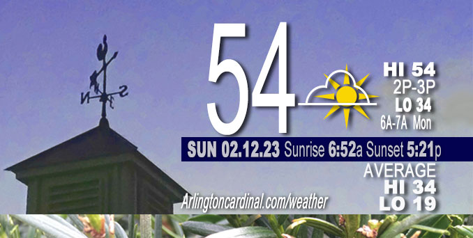
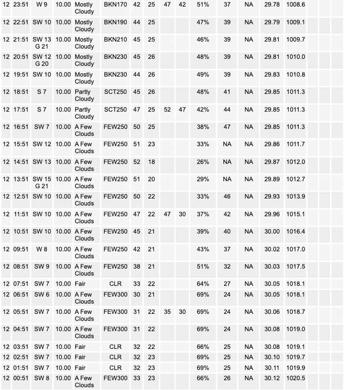
Sunday Hi 54, Sunny, clouds increase after 6p, winds SW to WSW, 7 to 9 to 6 MPH

NWS CHGO | NWS HRLY | /NWSchicago | 🌡
ARLINGTON HEIGHTS WEATHER
▴ forecast7 (Arl. Hts.) | RADAR | WIDE RADAR
⏪ Hrly Data Table | Hrly Future Graph ⏩
IMPORTANT NOTE ON NWS DATA
⏪ Hrly Data Table | Hrly Future Graph ⏩
======================
Sunday and Sunday Evening …
No Weather Hazards expected …
Above normal temperatures: unseasonably mild conditions are expected to continue Sunday and into Monday. The normal high for February 12 is 34°F, so we could reach over 20°F above normal on Sunday and Monday. Above normal temperatures are also expected Tuesday and Wednesday, but with some rain.
DISCUSSION…
Almost full sunshine can be expected across the region Sunday. While some stray strips of cirrus may be seen passing overhead at times Sunday morning and afternoon, the more extensive high cloud cover won`t arrive over Chicagoland until the latter half of Sunday afternoon or evening. Optimal warming conditions: insulating clouds increase after 6:00 p.m. Sunday, then decrease below 50% cloud cover after sunrise Monday. High temperatures have overperformed most guidance these past two days of uninhibited sunshine, and may overperform Sunday and Monday, too.
Daily low temperatures and daily high temperatures are on the way up. We’re gaining about 2 minutes of daylight every day in the progression toward vernal equinox, March 20, 2023. Daylight increased three minutes Sunday.
======================
O’HARE FORECAST …
Forecast Beginning Sunday, Feb. 12, 2023
Sunday: Sunny, with a high near 54. Southwest wind 5 to 10 mph.
Sunday Night: Increasing clouds, with a low around 34. West southwest wind around 5 mph, with gusts as high as 10 mph.
Monday: Sunny, with a high near 54. West wind 5 to 10 mph, with gusts as high as 20 mph.
Monday Night: Mostly clear, with a low around 32. West southwest wind 5 to 10 mph becoming south after midnight.
Tuesday: Rain likely after noon. Mostly cloudy, with a high near 51. Breezy, with a south wind 10 to 15 mph increasing to 15 to 20 mph in the afternoon. Winds could gust as high as 35 mph. Chance of precipitation is 60%.
Tuesday Night: Rain, mainly before midnight. Low around 46. Breezy. Chance of precipitation is 80%.
Wednesday: Partly sunny, with a high near 53. Breezy.
Wednesday Night: A chance of rain after midnight. Mostly cloudy, with a low around 36.
Thursday: Rain likely before noon, then rain and snow likely. Mostly cloudy, with a high near 44. Breezy.
Thursday Night: A chance of rain and snow before midnight. Mostly cloudy, with a low around 19. Blustery.
Friday: Partly sunny, with a high near 28.
Friday Night: Mostly clear, with a low around 20.
Saturday: Sunny, with a high near 42. Breezy.


CHICAGOWEATHERSTATION.COM
ChicagoWeatherStation.com I O’Hare Normal Temps/Precip I O’Hare Record Temps, Precip, Snow
LIVE RADAR | STORM TRACKS | UNISYS US IR SAT | UNISYS Midwest IR SAT | UNISYS More IR SAT
WunderMap® with Temperature/Wind Data || Google: Arlington Heights Area Temps | US TEMPS
Full Screen Motion Weather Radar (Wunderground.com)
Midwest Cloud Cover with Arlington Heights Weather Forecast
ChicagoWeatherStation.com I O’Hare Normal Temps/Precip I O’Hare Record Temps, Precip, Snow
SUNLIGHT DATA FOR SECURITY, TRAFFIC SAFETY, AND SPORTS
SunCalc.net data with solar azimuth and trajectory, times for dawn, sunrise, solar noon, sunset, dusk …
NIGHT SKY THIS MONTH …
Backyard stargazers get a monthly guide to the northern hemisphere’s skywatching events with “Tonight’s Sky.” Check the night sky objects for this month and past months in the playlist from the Space Telescope Science Institute YouTube channel (Musical track The Far River written by Jonn Serrie, from the album And the Stars Go With You courtesy of New World Music Ltd).
Get updates from The Cardinal ALL NEWS FEEDS on Facebook. Just ‘LIKE’ the ‘Arlington Cardinal Page (become a fan of our page). The updates cover all posts and sub-category posts from The Cardinal — Arlingtoncardinal.com. You can also limit feeds to specific categories. See all of The Cardinal Facebook fan pages at Arlingtoncardinal.com/about/facebook …
Help fund The Cardinal Arlingtoncardinal.com/sponsor
Area Forecast Discussion
National Weather Service Chicago/Romeoville, IL
508 AM CST Sun Feb 12 2023
.SHORT TERM… Issued at 158 AM CST Sun Feb 12 2023
Through Monday…
Tranquil and unseasonably mild conditions are expected to continue today and into Monday.
Another day featuring abundant sunshine can be expected across the region today. While some stray strips of cirrus may be seen passing overhead at times this morning and afternoon, the more extensive high cloud cover won`t arrive in our CWA until the latter half of this afternoon or this evening. High temperatures have overperformed most guidance these past two days of uninhibited sunshine, and barring an unexpected earlier arrival of the vaster cirrus canopy, there`s no reason to think that they won`t do the same today. Have bumped our forecasted high temperatures for today up a few degrees to range from the upper 40s to mid 50s across our forecast area, which should better reflect the likelihood of temperatures overperforming forecast guidance again.
The feature that will be responsible for cloud cover increasing as we head into this evening is a mid-level impulse that, as of this writing, resides over the Rocky Mountains of Colorado and New Mexico. While the overhead cloud deck may grow to be a few thousand feet deep as this fairly unimpressive impulse passes through the area, rather parched air in the low and mid-levels of the atmosphere will deny the opportunity for any descending hydrometeors to survive to ground level.
As the mid-level impulse and an attendant surface frontal trough depart the area early Monday morning, the overnight cloud cover will quickly disappear beyond the horizon, while ridging will begin to build northward towards our latitude, setting the stage for our early taste of spring to continue as the workweek begins. Have increased our forecast high temperatures for Monday by several degrees from the inherited NBM-based forecast to advertise low-mid 50s across much of our forecast area. This brings our temperature forecast to be more in line with the most recent output of some of the better performing forecast guidance from the past few days, though given the high likelihood of Monday being another day featuring mostly unobstructed solar insolation, could foresee daytime temperatures overperforming once again, so additional consideration may need to be given to increasing temperatures even further by a few degrees in forthcoming forecast packages.
Ogorek/NWS Chicago


