
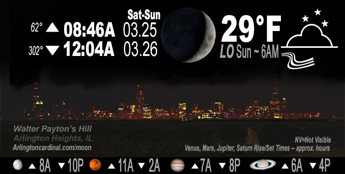
🌒 🌓 🌕 🌗 Waxing Crescent Moon, rain, sky cover overnight Sat. to Sun. 30% to 12% to 40%, winds WSE to WNW, 11 to 2 MPH, G20 to 11 MPH until 2a, Low 29, 6a to 7a
NWS CHGO | NWS HRLY | /NWSchicago | 🌡
ARLINGTON HEIGHTS WEATHER
▴ forecast7 (Arl. Hts.) | RADAR | WIDE RADAR
IMPORTANT NOTE ON NWS DATA
Hello mobile users! If you encounter a mobile “unfriendly” weather page, turn your phone sideways for a better view.
======================
NIGHT FORECASTS …
NOTE: Keep in mind lunar rise and set times don’t always correspond with night weather and early morning lows because on some days during the month the moon is visible in the sky predominantly during the daytime hours.
Overnight Saturday/Sunday …
No Weather Hazards expected …
Skies clearing after 7:00 p.m.
DISCUSSION…
Our latest storm system continues to pull away from the region with a very impressive/classic look of a mature mid-latitude cyclone on satellite loops. Incredibly sharp gradient in snow accumulations is showing up nicely in the Day Snow-Fog imagery as lingering high cloud cover thins, with exceptional totals noted across far NW Illinois into SW Wisconsin. Skies will clear rapidly from west-to-east through the remainder of the afternoon, and temperatures will likely spike a bit. Impressively, seeing lower 50 degree readings at this hour across eastern Iowa which is melting the newly-minted snowpack visibly on each new satellite frame.
======================
O’HARE FORECAST …
Forecast Beginning Saturday Night, Mar. 25, 2023 …
Saturday Night: A slight chance of rain and snow before 7pm. Mostly clear, with a low around 28. West wind 5 to 10 mph, with gusts as high as 25 mph. Chance of precipitation is 10%.
Sunday: A 20 percent chance of rain after 2pm. Increasing clouds, with a high near 42. Calm wind becoming east northeast around 5 mph in the afternoon.
Sunday Night: A slight chance of rain before 2am, then a chance of rain and snow. Mostly cloudy, with a low around 33. Northeast wind 5 to 10 mph, with gusts as high as 15 mph. Chance of precipitation is 30%.
Monday: A 40 percent chance of rain. Mostly cloudy, with a high near 42. Northeast wind 10 to 15 mph.
Monday Night: A chance of rain and snow. Mostly cloudy, with a low around 31. Chance of precipitation is 30%.
Tuesday: A 30 percent chance of rain, mainly before 8am. Partly sunny, with a high near 44.
Tuesday Night: Mostly clear, with a low around 28.
Wednesday: Partly sunny, with a high near 46.
Wednesday Night: A chance of rain after 2am. Mostly cloudy, with a low around 34.
Thursday: A chance of showers. Mostly cloudy, with a high near 46.
Thursday Night: Showers. Cloudy, with a low around 39.
Friday: Showers. Mostly cloudy, with a high near 54.
O’Hare forecast archive and hourly weather observations archive are available HERE on the CARDINAL NEWS Magazine.
Arlingtoncardinal.com/moonphases
Arlingtoncardinal.com/nightsky
NIGHT SKY THIS MONTH …
Check the night sky objects for this month and past months in the playlist from the Space Telescope Science Institute YouTube channel Backyard stargazers get a monthly guide to the northern hemisphere’s skywatching events with “Tonight’s Sky” (Musical track The Far River written by Jonn Serrie, from the album And the Stars Go With You courtesy of New World Music Ltd. Musical track The Far River written by Jonn Serrie, from the album And the Stars Go With You courtesy of New World Music Ltd).
Telephoto lens, ISO 100, f/11, Shutter Speed 1/100 to 1/125 for the Moon.
Get updates from The Cardinal ALL NEWS FEEDS on Facebook. Just ‘LIKE’ the ‘Arlington Cardinal Page (become a fan of our page). The updates cover all posts and sub-category posts from The Cardinal — Arlingtoncardinal.com. You can also limit feeds to specific categories. See all of The Cardinal Facebook fan pages at Arlingtoncardinal.com/about/facebook …
Help fund The Cardinal Arlingtoncardinal.com/sponsor
Telephoto lens, ISO 1600, f/11, Shutter Speed 2.5″ for the skyline. The skyline exposure was toned down, and brightness and contrast was adjusted in Photoshop.
/////////////>
Area Forecast Discussion
National Weather Service Chicago/Romeoville, IL
633 PM CDT Sat Mar 25 2023
.SHORT TERM… Issued at 207 PM CDT Sat Mar 25 2023
Through Sunday night…
The main weather notes in the short term are:
* Increasing precipitation coverage late tonight into Sunday with snow possible across mainly far northern Illinois (no travel impacts expected).
* Subtle severe weather risk evident south of I-80 midday into the afternoon with a potential for a few low-topped supercells.
Our latest storm system continues to pull away from the region with a very impressive/classic look of a mature mid-latitude cyclone on satellite loops. Incredibly sharp gradient in snow accumulations is showing up nicely in the Day Snow-Fog imagery as lingering high cloud cover thins, with exceptional totals noted across far NW Illinois into SW Wisconsin. Skies will clear rapidly from west-to-east through the remainder of the afternoon, and temperatures will likely spike a bit. Impressively, seeing lower 50 degree readings at this hour across eastern Iowa which is melting the newly-minted snowpack visibly on each new satellite frame.
Gusty westerly breezes will come down sharply this evening as we turn our attention to the next disturbance which is pivoting into western Kansas and Nebraska. Quite the cumuliform/bumpy look to visible satellite imagery which elucidates the steep lapse rate environment within this feature`s warm advection wing. Trend in guidance has been a northward one and slightly deeper/sharper in the upper levels. While the attendant surface reflection/low won`t be particularly deep (1012-1014 mb), large scale forcing for ascent upstairs is actually pretty good given intense system- preceding DCVA and pockets of better upper divergence along the cyclonic shear side of a 130 kt jet streak. Have greatly boosted PoPs across my area, mainly Sunday morning and afternoon. Some hires guidance also develops some spotty showers late this evening/early overnight across parts of central Illinois within an initial zone of intensifying isentropic upglide. Not super confident in this right now, but either way, thermal profiles look like they`d be a cold rain if anything developed.
Profiles across far northern Illinois will be just cold enough to support snow or a rain/snow mix Sunday morning and possibly into the afternoon. Showing a little in the way of accumulations, but in reality, looks like snow would melt as fast as it falls with no travel impacts expected due to above-freezing temperatures.
More interestingly, a strong-severe weather threat is a bit more evident in today`s guidance from midday Sunday through the afternoon given the aforementioned northward shift in the low track. Sharpening warm frontal zone looks to set up shop pretty much right over I-80, with a developing free warm sector to the south. Mid 40s to even near 50 degree dewpoints are advertised to spread northward through the day along with steepening low-level lapse rates. Destabilization, to some degree, will depend on how much clearing is realized, but still seeing good agreement in 0-3 km MLCAPE values spiking above 100 J/kg south of I-80 (even higher if you believe the RAP). A small but highly diffluent 50 kt 700 mb jet streak is forecast to impinge on this region during the afternoon, yielding commensurate increases in deep layer shear (given ELs around 6-7 km, “deep layer” shear in this case is probably closer to 0-3/0-4 km). While the surface flow is forecast to veer readily, limiting hodograph curvature to some degree, this set up looks conducive to a few low-topped supercells. While low-level moisture isn`t particularly robust, an isolated damaging wind or brief tornado threat is possible in this regime, and earlier coordinated the introduction of a level 1 of 5 severe risk south of I-80 and east of about I-55.
Severe risk will wane quickly in the evening. A little rain/snow may continue across parts of northern and northeast Illinois for a period, but thereafter expecting largely dry conditions overnight. Follow-up wave may remain largely south of our area overnight, and have commensurately cut precip chances a bit.
Carlaw/NWS Chicago
