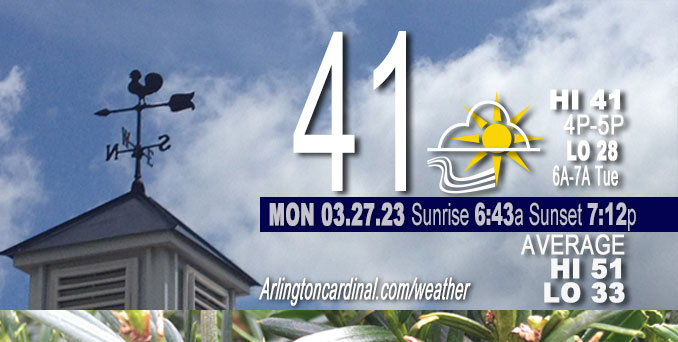
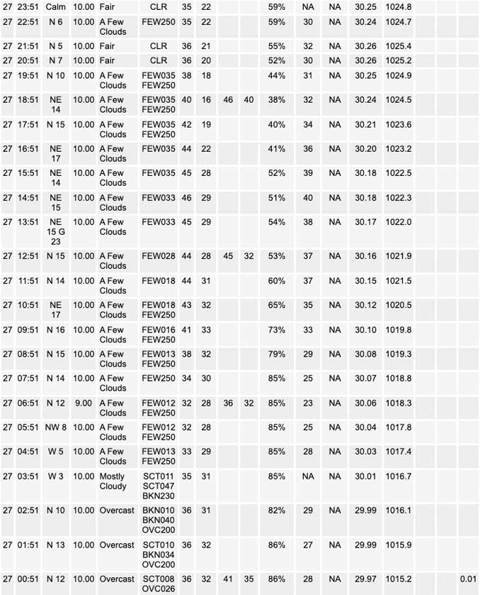
Monday Hi 41, partly sunny, winds NNE to NE to NNE, 11 to 5 to 6 MPH, G18 to 17 to 18 to 14 MPH, until 6p

NWS CHGO | NWS HRLY | /NWSchicago | 🌡
ARLINGTON HEIGHTS WEATHER
▴ forecast7 (Arl. Hts.) | RADAR | WIDE RADAR
⏪ Hrly Data Table | Hrly Future Graph ⏩
IMPORTANT NOTE ON NWS DATA
⏪ Hrly Data Table | Hrly Future Graph ⏩
Hello mobile users! If you encounter a mobile “unfriendly” weather page, turn your phone sideways for a better view.
======================
Monday and Monday Evening …
No Weather Hazards expected …
DISCUSSION…
Early this morning, most of the area sits underneath a low stratus deck in the wake of a low level trough seated overhead. The far northwestern CWA is an exception being on the windward side of the trough axis where moisture in the low levels is cut off and we`re seeing clear skies overhead. As the trough pushes eastward and dry air works in behind, we will see the cloudy skies taper off to the east through the rest of the morning. By the afternoon, most of the area should be seeing more blue sky than clouds. Temperatures will be just a few degrees below normal today with highs climbing into the lower and middle 40s.
======================
O’HARE FORECAST …
Forecast Beginning Monday, Mar. 27, 2023
Monday: Partly sunny, with a high near 42. North northeast wind 10 to 15 mph, with gusts as high as 20 mph.
Monday Night: Partly cloudy, with a low around 30. North northeast wind 5 to 10 mph.
Tuesday: Partly sunny, with a high near 47. Calm wind becoming west around 5 mph in the afternoon. Winds could gust as high as 10 mph.
Tuesday Night: Partly cloudy, with a low around 33. Southwest wind 10 to 15 mph.
Wednesday: A chance of rain and snow. Mostly cloudy, with a high near 44. Chance of precipitation is 30%.
Wednesday Night: Partly cloudy, with a low around 27.
Thursday: A chance of rain after 1pm. Mostly cloudy, with a high near 54.
Thursday Night: Rain, mainly after 1am. Mostly cloudy, with a low around 49. Breezy.
Friday: Rain. Mostly cloudy, with a high near 63. Breezy.
Friday Night: Rain likely. Mostly cloudy, with a low around 38. Breezy.
Saturday: A chance of rain and snow. Partly sunny, with a high near 46.
Saturday Night: Partly cloudy, with a low around 29.
Sunday: Mostly sunny, with a high near 48.


CHICAGOWEATHERSTATION.COM
ChicagoWeatherStation.com I O’Hare Normal Temps/Precip I O’Hare Record Temps, Precip, Snow
LIVE RADAR | STORM TRACKS | UNISYS US IR SAT | UNISYS Midwest IR SAT | UNISYS More IR SAT
WunderMap® with Temperature/Wind Data || Google: Arlington Heights Area Temps | US TEMPS
Full Screen Motion Weather Radar (Wunderground.com)
Midwest Cloud Cover with Arlington Heights Weather Forecast
ChicagoWeatherStation.com I O’Hare Normal Temps/Precip I O’Hare Record Temps, Precip, Snow
SUNLIGHT DATA FOR SECURITY, TRAFFIC SAFETY, AND SPORTS
SunCalc.net data with solar azimuth and trajectory, times for dawn, sunrise, solar noon, sunset, dusk …
NIGHT SKY THIS MONTH …
Backyard stargazers get a monthly guide to the northern hemisphere’s skywatching events with “Tonight’s Sky.” Check the night sky objects for this month and past months in the playlist from the Space Telescope Science Institute YouTube channel (Musical track The Far River written by Jonn Serrie, from the album And the Stars Go With You courtesy of New World Music Ltd).
Get updates from The Cardinal ALL NEWS FEEDS on Facebook. Just ‘LIKE’ the ‘Arlington Cardinal Page (become a fan of our page). The updates cover all posts and sub-category posts from The Cardinal — Arlingtoncardinal.com. You can also limit feeds to specific categories. See all of The Cardinal Facebook fan pages at Arlingtoncardinal.com/about/facebook …
Help fund The Cardinal Arlingtoncardinal.com/sponsor
/////////////>
Area Forecast Discussion
National Weather Service Chicago/Romeoville, IL
623 AM CDT Mon Mar 27 2023
.SHORT TERM… Issued at 332 AM CDT Mon Mar 27 2023
Through Tuesday…
The short term forecast is an awfully quiet one with not a ton to speak on. Early this morning, most of the area sits underneath a low stratus deck in the wake of a low level trough seated overhead. The far northwestern CWA is an exception being on the windward side of the trough axis where moisture in the low levels is cut off and we`re seeing clear skies overhead. As the trough pushes eastward and dry air works in behind, we will see the cloudy skies taper off to the east through the rest of the morning. By the afternoon, most of the area should be seeing more blue sky than clouds. Temperatures will be just a few degrees below normal today with highs climbing into the lower and middle 40s. The mostly clear skies will persist into the late evening before clouds begin to build overnight. A weak little wave is forecast to feed in a thin layer of layer of moisture right around 800-750mb that will allow for the added cloud cover. This means we`ll be waking up to mostly cloudy skies on Tuesday. A few showers may develop Tuesday morning just south of the area along the wave`s track where saturation is a bit deeper. However, forcing and moisture availability look far too scarce to expect any preci Pin our area aside from perhaps a few sprinkles or flurries south of the Kankakee River. Drier air advecting in behind the wave will once again eat away at the cloud cover through the afternoon. Expect highs on Tuesday in the upper 40s to near 50 degrees.
Doom/NWS Chicago


