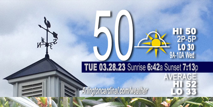
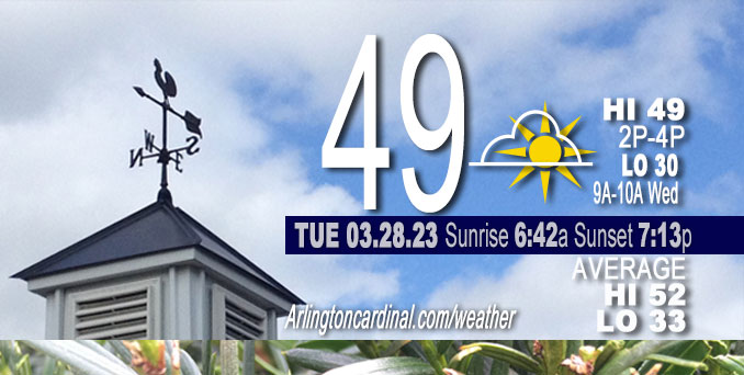
Tuesday Hi 50, partly sunny to partly cloudy, winds NW to W to SW, 1 to 10 to 8 MPH, G14 MPH, 3p


NWS CHGO | NWS HRLY | /NWSchicago | 🌡
ARLINGTON HEIGHTS WEATHER
▴ forecast7 (Arl. Hts.) | RADAR | WIDE RADAR
⏪ Hrly Data Table | Hrly Future Graph ⏩
IMPORTANT NOTE ON NWS DATA
⏪ Hrly Data Table | Hrly Future Graph ⏩
Hello mobile users! If you encounter a mobile “unfriendly” weather page, turn your phone sideways for a better view.
======================
Tuesday and Tuesday Evening …
No Weather Hazards expected …
Partly sunny, with a high near 50. Light and variable wind becoming west 5 to 10 mph in the morning. Winds could gust as high as 15 mph.
DISCUSSION…
High clouds begin to move overhead toward daybreak which may help limit additional cooling. If this area of clouds arrives more slowly the forecast low temperatures may be a bit too warm.
High temperatures on Tuesday will be similar to today for inland areas, though with a westerly wind direction, temperatures will be able to warm closer to the lake with mid 40s to near 50 degrees forecast across the area. A low-amplitude wave will move across central Illinois on Tuesday along which will push mid-level clouds across the area. Cannot rule out a few sprinkles or stray shower Tuesday afternoon with this feature, though think that dry air in the low-levels is pronounced enough to limit this to mainly virga.
======================
O’HARE FORECAST …
Forecast Beginning Tuesday, Mar. 28, 2023
Tuesday: Partly sunny, with a high near 50. Light and variable wind becoming west 5 to 10 mph in the morning. Winds could gust as high as 15 mph.
Tuesday Night: Increasing clouds, with a low around 32. West southwest wind 5 to 10 mph, with gusts as high as 15 mph.
Wednesday: Snow likely, mainly before 10am. Cloudy, then gradual clearing during the afternoon, with a high near 39. West southwest wind 10 to 15 mph becoming north northwest in the afternoon. Winds could gust as high as 25 mph. Chance of precipitation is 60%. New snow accumulation of less than a half inch possible.
Wednesday Night: Mostly clear, with a low around 25. North northwest wind around 5 mph becoming calm in the evening. Winds could gust as high as 10 mph.
Thursday: A 20 percent chance of rain after 1pm. Mostly sunny, with a high near 53.
Thursday Night: Rain, mainly after 1am. Low around 46. Breezy. Chance of precipitation is 80%.
Friday: A chance of rain, then rain and possibly a thunderstorm after 1pm. Mostly cloudy, with a high near 65. Breezy.
Friday Night: Rain and possibly a thunderstorm before 1am, then a chance of rain. Mostly cloudy, with a low around 35. Breezy.
Saturday: A chance of rain and snow before 1pm. Partly sunny, with a high near 44. Breezy.
Saturday Night: Mostly clear, with a low around 30.
Sunday: Mostly sunny, with a high near 57.
Sunday Night: Partly cloudy, with a low around 45. Breezy.
Monday: A chance of rain. Partly sunny, with a high near 61.


CHICAGOWEATHERSTATION.COM
ChicagoWeatherStation.com I O’Hare Normal Temps/Precip I O’Hare Record Temps, Precip, Snow
LIVE RADAR | STORM TRACKS | UNISYS US IR SAT | UNISYS Midwest IR SAT | UNISYS More IR SAT
WunderMap® with Temperature/Wind Data || Google: Arlington Heights Area Temps | US TEMPS
Full Screen Motion Weather Radar (Wunderground.com)
Midwest Cloud Cover with Arlington Heights Weather Forecast
ChicagoWeatherStation.com I O’Hare Normal Temps/Precip I O’Hare Record Temps, Precip, Snow
SUNLIGHT DATA FOR SECURITY, TRAFFIC SAFETY, AND SPORTS
SunCalc.net data with solar azimuth and trajectory, times for dawn, sunrise, solar noon, sunset, dusk …
NIGHT SKY THIS MONTH …
Backyard stargazers get a monthly guide to the northern hemisphere’s skywatching events with “Tonight’s Sky.” Check the night sky objects for this month and past months in the playlist from the Space Telescope Science Institute YouTube channel (Musical track The Far River written by Jonn Serrie, from the album And the Stars Go With You courtesy of New World Music Ltd).
Get updates from The Cardinal ALL NEWS FEEDS on Facebook. Just ‘LIKE’ the ‘Arlington Cardinal Page (become a fan of our page). The updates cover all posts and sub-category posts from The Cardinal — Arlingtoncardinal.com. You can also limit feeds to specific categories. See all of The Cardinal Facebook fan pages at Arlingtoncardinal.com/about/facebook …
Help fund The Cardinal Arlingtoncardinal.com/sponsor
/////////////>
Area Forecast Discussion
National Weather Service Chicago/Romeoville, IL
630 AM CDT Tue Mar 28 2023
.SHORT TERM… Issued at 347 AM CDT Tue Mar 28 2023
Through Wednesday…
The main main weather highlight during the short term period is the continued likelihood for quick hit of accumulating snow in association with a strong cold frontal passage Wednesday morning.
A weak surface ridge of high pressure is resulting in light winds and mainly clear skies overhead early this morning. However, mid and high level cloud cover is quickly shifting into western sections of the area in advance of the next mid-level impulse, which will track across the Lower Missouri Valley this morning. This will set up a mostly cloudy morning across our area, though we may see some peeks of sunshine this afternoon. Precipitation associated with this disturbance is expected to remain to our southwest this morning, and will then begin to fight with a drier low-level airmass with eastward extent into southern IL into this afternoon. It thus appears the area will remain precipitation free today, with no more than an isolated afternoon sprinkle possible over southern sections of the area. Expect seasonably mild temperatures nearing 50 degrees inland of the lake this afternoon. An afternoon lake breeze is likely to result in cooler conditions at the lake front.
Tonight forecast attention turns to the potent northern stream shortwave impulse expected to drop out of the Arrowhead region of Minnesota. This feature will drive a substantial surface cold front south across the area Wednesday. Forecast guidance this morning continues to support a narrow band of strong forcing for ascent along this frontal boundary as a rather sharp baroclinic zone shifts into northern parts of IL around daybreak Wednesday. The strongest DCVA and mid-level height falls supporting the most robust deep layer forced ascent with the approaching impulse are expected to largely pass to our northeast across Wisconsin and Lower Michigan. However, northeastern IL and far northwestern IN will still likely see a glancing hit of this better forcing Wednesday morning concurrent with the arrival of a reservoir of steep mid-level lapse rates accompanying the surface boundary. With all this in mind, we have continued the trend of boosting POPs into the categorical range, especially across far northern and northeastern IL early Wednesday morning.
Thermal profiles are expected to cool quickly with the front as forced ascent is maximized right through the DGZ, and this continues to raise concerns that a brief (1 to 2 hour period), but robust band of snow will develop with, and just in the wake of, this frontal boundary. While the short duration of this band of snow will not result in much accumulation (likely an inch or less), the poor timing, coming right during the morning commute, may result in some adverse travel impacts. We therefore need to continue to monitor this closely.
Blustery northerly winds are expected to accompany the frontal passage and burst of snow in the morning. However, once this band of snow shifts southeastward across the area in the morning, conditions will clear out and winds should gradually ease through the afternoon. The afternoon sunshine may actually hel Ptemperatures recover back into the upper 30s during the afternoon following the frontal passage.
KJB/NWS Chicago
…
1221 AM CDT Tue Mar 28 2023
.SHORT TERM… Issued at 245 PM CDT Mon Mar 27 2023
Through Tuesday night…
Temperatures have warmed into the mid to upper 40s across the area this afternoon in spite of cooler air blowing off the southern WI snowpack and Lake Michigan. Areas along the immediate shore and in areas with lingering snow-pack are still in the lower 40, however. Strato-cu has also developed this afternoon, mainly in areas that are not downwind of Lake Michigan where skies have remained clear to mostly clear. Breezy northeast winds will ease after sunset becoming light and variable under the influence of surface high pressure. Skies will clear out initially with temperatures dipping into the upper 20s to lower 30s overnight. High clouds begin to move overhead toward daybreak which may hel Plimit additional cooling. If this area of clouds arrives more slowly the forecast low temperatures may be a bit too warm.
High temperatures on Tuesday will be similar to today for inland areas, though with a westerly wind direction, temperatures will be able to warm closer to the lake with mid 40s to near 50 degrees forecast across the area. A low-amplitude wave will move across central Illinois on Tuesday along which will push mid- level clouds across the area. Cannot rule out a few sprinkles or stray shower Tuesday afternoon with this feature, though think that dry air in the low-levels is pronounced enough to limit this to mainly virga. For now have opted to keep the gridded forecast dry with this update. Our next best chance of precipitation will arrive toward daybreak Wednesday along a cold front. More details on the potential snow showers can be found in the Long Term section below.
Petr/NWS Chicago


