
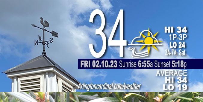
Friday Hi 34, decreasing clouds to partly cloudy, winds NW to W, 11 to 13 to 3 MPH, G20 to 14 MPH ending 7p
NWS CHGO | NWS HRLY | /NWSchicago | 🌡
ARLINGTON HEIGHTS WEATHER
▴ forecast7 (Arl. Hts.) | RADAR | WIDE RADAR
⏪ Hrly Data Table | Hrly Future Graph ⏩
IMPORTANT NOTE ON NWS DATA
⏪ Hrly Data Table | Hrly Future Graph ⏩
======================
Friday and Friday Night …
No Weather Hazards expected …
Near normal temperatures but gusty winds from the northwest around 20 MPH most of the day.
DISCUSSION…
The low pressure system that passed through Thursday is now well off to our northeast in Quebec, and with a region of high pressure centered along the Colorado Front Range around 3:00 a.m. Friday expected to continue expanding into the central Plains and eventually the Midwest by Friday night, daytime Friday should mark beginning of another stretch of quiet weather (although windy Saturday) for northern Illinois and northwest Indiana.
Daily low temperatures and daily high temperatures are on the way up. We’re gaining about 2 minutes of daylight every day in the progression toward vernal equinox, March 20, 2023. Friday, both the normal low (19°F) and the normal high (34°F) have increased by 1°F on February 10.
======================
O’HARE FORECAST …
Forecast Beginning Friday, Feb. 10, 2023
Friday: Sunny, with a high near 35. Northwest wind 10 to 15 mph, with gusts as high as 20 mph.
Friday Night: Clear, with a low around 24. Northwest wind 5 to 10 mph becoming southwest after midnight. Winds could gust as high as 15 mph.
Saturday: Sunny, with a high near 43. Southwest wind 5 to 15 mph, with gusts as high as 20 mph.
Saturday Night: Clear, with a low around 28. Southwest wind 10 to 15 mph, with gusts as high as 20 mph.
Sunday: Sunny, with a high near 46. Southwest wind around 10 mph, with gusts as high as 15 mph.
Sunday Night: Mostly cloudy, with a low around 31.
Monday: Sunny, with a high near 46.
Monday Night: Mostly clear, with a low around 30.
Tuesday: A chance of rain after noon. Partly sunny, with a high near 49.
Tuesday Night: Rain, mainly before midnight. Cloudy, with a low around 43.
Wednesday: Partly sunny, with a high near 56.
Wednesday Night: A chance of rain. Mostly cloudy, with a low around 39.
Thursday: Rain and snow likely. Mostly cloudy, with a high near 44. Breezy.


CHICAGOWEATHERSTATION.COM

ChicagoWeatherStation.com I O’Hare Normal Temps/Precip I O’Hare Record Temps, Precip, Snow
LIVE RADAR | STORM TRACKS | UNISYS US IR SAT | UNISYS Midwest IR SAT | UNISYS More IR SAT
WunderMap® with Temperature/Wind Data || Google: Arlington Heights Area Temps | US TEMPS
Full Screen Motion Weather Radar (Wunderground.com)
Midwest Cloud Cover with Arlington Heights Weather Forecast
ChicagoWeatherStation.com I O’Hare Normal Temps/Precip I O’Hare Record Temps, Precip, Snow
SUNLIGHT DATA FOR SECURITY, TRAFFIC SAFETY, AND SPORTS
SunCalc.net data with solar azimuth and trajectory, times for dawn, sunrise, solar noon, sunset, dusk …
NIGHT SKY THIS MONTH …
Backyard stargazers get a monthly guide to the northern hemisphere’s skywatching events with “Tonight’s Sky.” Check the night sky objects for this month and past months in the playlist from the Space Telescope Science Institute YouTube channel (Musical track The Far River written by Jonn Serrie, from the album And the Stars Go With You courtesy of New World Music Ltd).
Get updates from The Cardinal ALL NEWS FEEDS on Facebook. Just ‘LIKE’ the ‘Arlington Cardinal Page (become a fan of our page). The updates cover all posts and sub-category posts from The Cardinal — Arlingtoncardinal.com. You can also limit feeds to specific categories. See all of The Cardinal Facebook fan pages at Arlingtoncardinal.com/about/facebook …
Help fund The Cardinal Arlingtoncardinal.com/sponsor
Area Forecast Discussion
National Weather Service Chicago/Romeoville, IL
521 AM CST Fri Feb 10 2023
.SHORT TERM… Issued at 251 AM CST Fri Feb 10 2023
Through Saturday…
Yesterday`s low pressure system is now well off to our northeast in Quebec, and with a region of high pressure centered along the Colorado Front Range at press time expected to continue expanding into the central Plains and eventually the Midwest by tonight, today should mark beginning of another stretch of quiescent weather for northern Illinois and northwest Indiana. Dry air advection on the backside of the departing low will continue to eat away at our residual stratus deck this morning, and clear/mostly clear skies are expected to prevail across the area by mid-day as a result. With the cloud cover now expected to clear out a little quicker compared to previous forecasts, did bump our forecasted high temperatures for today up a few degrees to account for the expected greater quantity of solar insolation. Modest cold air advection off of northwesterly winds should still ensure that most of the CWA will see highs that won`t make it out of the 30s, but do think that we`ll still see some 40+ degree readings in our southern counties this afternoon.
As the surface high pressure ridge noses into the area tonight, winds will slacken off a good bit, and combined with clear skies, this could lead to the development of at least patchy radiation fog within our CWA by daybreak Saturday. Aside from the lower end chance that Saturday morning`s fog becomes locally dense, no impactful weather is otherwise expected on Saturday as high pressure continues to preside over the region between a sheared northern stream wave translating across Ontario and a cutoff low that will meander along the Gulf and southern Atlantic coasts this weekend. It should still be noted, though, that the influence of the northern stream system should still be felt locally to some extent as the surface pressure gradient tightens over the Great Lakes in response to an associated 1002 mb surface low to our north sliding across our longitude. With the surface ridge still in close proximity to our southern CWA, there will be a stark contrast in windiness between our northern and southern counties during the daytime hours on Saturday with our northern tier or two of counties likely to see a period of breezy southwesterly winds gusting to 20-30 mph during the late morning and afternoon, while winds remain calm or light throughout the day in our southern counties. Otherwise, Saturday`s highs are currently favored to top out in the low-mid 40s across most of our forecast area.
Ogorek/NWS Chicago
