
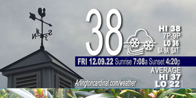
FRIDAY Hi 38, mostly cloudy, light snow and rain, winds E, 13 to 8 MPH, G21 to 14 MPH until 10p
NWS CHGO | NWS HRLY | /NWSchicago | 🌡
ARLINGTON HEIGHTS WEATHER
▴ forecast7 (Arl. Hts.) | RADAR | WIDE RADAR
⏪ Hrly Data Table | Hrly Future Graph ⏩
IMPORTANT NOTE ON NWS DATA
⏪ Hrly Data Table | Hrly Future Graph ⏩
======================
Friday and Friday Night …
Weather Hazards expected…
Hazardous Weather Outlook
National Weather Service Chicago/Romeoville IL
400 AM CST Fri Dec 9 2022
ILZ003>006-008-010>013-019>021-023-032-033-039-103>108-INZ001-002-
010-011-019-101000-
Winnebago-Boone-McHenry-Lake IL-Ogle-Lee-De Kalb-Kane-DuPage-La Salle-Kendall-Grundy-Kankakee-Livingston-Iroquois-Ford-
Northern Cook-Central Cook-Southern Cook-Northern Will-Southern Will-Eastern Will-Lake IN-Porter-Newton-Jasper-Benton-
400 AM CST Fri Dec 9 2022 /500 AM EST Fri Dec 9 2022/
This Hazardous Weather Outlook is for portions of North Central
Illinois…Northeast Illinois and Northwest Indiana.
.DAY ONE…Today and Tonight.
Weather hazards expected…
Limited Fog Risk.
Elevated Snow Risk, primarily along and north of I-90.
Winter Weather Advisory in effect from December 9, 03:00 AM CST until December 9, 01:00 PM CST for Winnebago County, Boone County, McHenry County and Lake County.
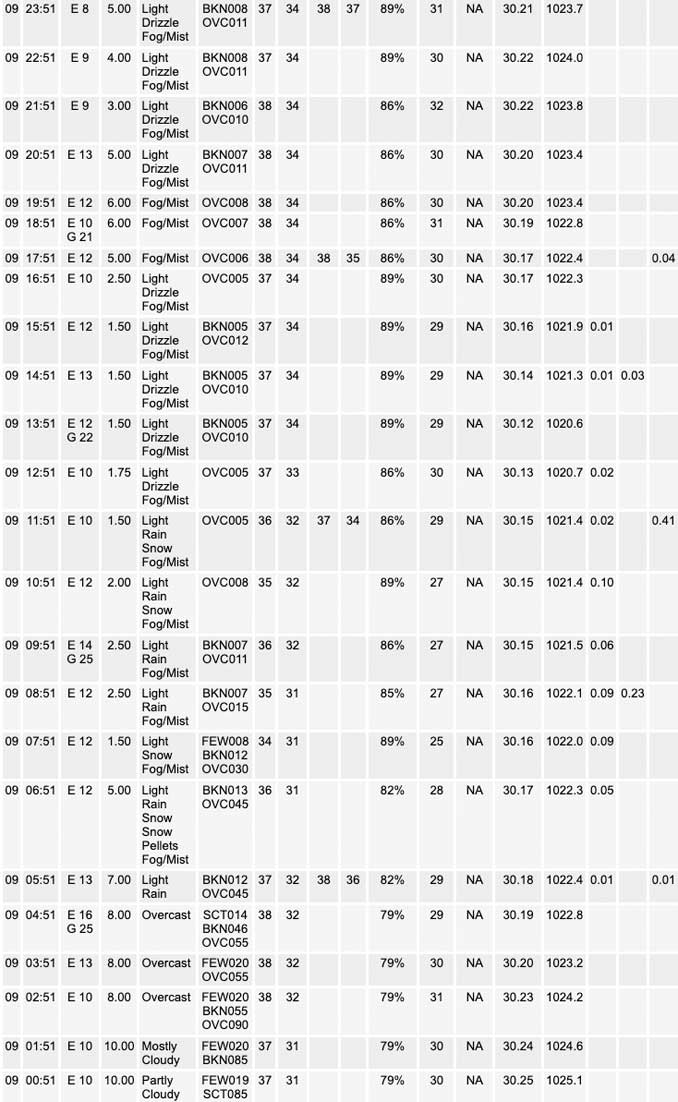
A mix of rain and snow is expected this morning roughly along and north of the I-80 corridor. Just rain is expected south of I-80, while roughly along and north of the I-88 corridor, and especially along and north of I-90, precipitation is expected to change over to all snow for up to a few hours. Slushy snow accumulations of u Pto 2-4″ may occur along and north of the I-90 corridor and produce hazardous travel conditions this morning.
Snow Accumulation Forecast — some locations possibly on grass only
Arlington Heights: 0.6 inch
Antioch: 2.0 inches
Lake Forest: 0.7 inch
Marengo: 1.9 inches
McHenry: 2.0 inches
Mundelein: 1.6 inches
Rockford: 1.3 inches
Waukegan: 1.0 inch
Snow Accumulation Reports for December 9, 2022 (9:00 AM Dec. 10 2022)
Arlington Heights: 0.4 inch
Hebron: 4.0 inches
Harvard: 3.1 inches
Woodstock: 2.0 inches
Fox Lake Hills: 2.0 inches
Long Lake: 2.0 inches
Mundelein: 1.6 inches
Chicago O’Hare: 0.2 inch
Rockford Airport: T
Romeoville (NWS Chicago): T (sleet)
Midway Airport: T
DISCUSSION…
While surface temperatures and wetbulbs will likely be hovering at, or just above freezing during the snow, some travel impacts are likely, both from reduced visibility and likely slushy accumulations on area roads. The main threat area for travel disruptions this morning continues to be favored across the northern tier counties in IL where the winter weather advisory resides.
Daylight loss is slowing down as we approach the Winter Solstice. No change in sunrise and sunset from Thursday to Friday.
Hello mobile users! If you encounter mobile “unfriendly” weather page, turn your phone sideways for a better view.
======================
O’HARE FORECAST …
Forecast Beginning Friday, Dec. 09, 2022
Friday: Rain and snow, possibly mixed with sleet before 1pm, then rain and snow between 1pm and 4pm, then rain likely after 4pm. Steady temperature around 35. East wind 10 to 15 mph, with gusts as high as 20 mph. Chance of precipitation is 100%. Total daytime snow and sleet accumulation of less than one inch possible.
Friday Night: A chance of rain or drizzle before 7pm, then a chance of drizzle, mainly between 7pm and 1am. Patchy fog after 7pm. Otherwise, cloudy, with a low around 36. East wind 5 to 10 mph, with gusts as high as 15 mph. Chance of precipitation is 40%.
Saturday: A slight chance of drizzle before 1pm, then a chance of drizzle with a slight chance of rain between 1pm and 4pm, then a chance of rain or drizzle after 4pm. Patchy fog before 9am. Otherwise, cloudy, with a high near 40. East southeast wind around 5 mph, with gusts as high as 15 mph. Chance of precipitation is 30%.
Saturday Night: A 30 percent chance of rain or drizzle, mainly before 7pm. Mostly cloudy, with a low around 35. East southeast wind around 5 mph becoming west northwest after midnight.
Sunday: Mostly cloudy, with a high near 43. Northwest wind around 5 mph, with gusts as high as 10 mph.
Sunday Night: Mostly cloudy, with a low around 34.
Monday: Mostly cloudy, with a high near 41.
Monday Night: Mostly cloudy, with a low around 33.
Tuesday: A chance of rain after 1pm. Mostly cloudy, with a high near 45.
Tuesday Night: Rain, mainly after 7pm. Cloudy, with a low around 37.
Wednesday: Rain. Mostly cloudy, with a high near 46.
Wednesday Night: A chance of rain. Mostly cloudy, with a low around 32.
Thursday: A chance of rain and snow. Mostly cloudy, with a high near 39.


CHICAGOWEATHERSTATION.COM

ChicagoWeatherStation.com I O’Hare Normal Temps/Precip I O’Hare Record Temps, Precip, Snow
LIVE RADAR | STORM TRACKS | UNISYS US IR SAT | UNISYS Midwest IR SAT | UNISYS More IR SAT
WunderMap® with Temperature/Wind Data || Google: Arlington Heights Area Temps | US TEMPS
Full Screen Motion Weather Radar (Wunderground.com)
Midwest Cloud Cover with Arlington Heights Weather Forecast
ChicagoWeatherStation.com I O’Hare Normal Temps/Precip I O’Hare Record Temps, Precip, Snow
SUNLIGHT DATA FOR SECURITY, TRAFFIC SAFETY, AND SPORTS
SunCalc.net data with solar azimuth and trajectory, times for dawn, sunrise, solar noon, sunset, dusk …
NIGHT SKY THIS MONTH …
Backyard stargazers get a monthly guide to the northern hemisphere’s skywatching events with “Tonight’s Sky.” Check the night sky objects for this month and past months in the playlist from the Space Telescope Science Institute YouTube channel (Musical track The Far River written by Jonn Serrie, from the album And the Stars Go With You courtesy of New World Music Ltd).
Get updates from The Cardinal ALL NEWS FEEDS on Facebook. Just ‘LIKE’ the ‘Arlington Cardinal Page (become a fan of our page). The updates cover all posts and sub-category posts from The Cardinal — Arlingtoncardinal.com. You can also limit feeds to specific categories. See all of The Cardinal Facebook fan pages at Arlingtoncardinal.com/about/facebook …
Help fund The Cardinal Arlingtoncardinal.com/sponsor
Area Forecast Discussion
National Weather Service Chicago/Romeoville, IL
623 AM CST Fri Dec 9 2022
.SHORT TERM… Issued at 331 AM CST Fri Dec 9 2022
Through Tonight…
The key messages for today are: * Precipitation, initially in the form of rain, developing eastward across the area prior to daybreak.
*Continued likelihood for the rain to change to about a 3 to 5 hour period of accumulating wet snow after 7 or 8 this morning through midday/early this afternoon, especially for areas along and north of I-88 and inland of Lake Michigan.
*Precipitation rates abate this afternoon, though light rain and drizzle may persist into tonight.
Early morning water vapor loops show a compact but vigorous shortwave impulse now shifting eastward across IA, with the initial arc of warm air advection driven precipitation now beginning to develop eastward across western parts of the area, especially along and west of I-39 as of this writing. Expect this arc of precipitation to shift into northeastern IL and northwestern IN by daybreak this morning, and persist through around midday/early afternoon before a mid-level dry punch brings an end to the heavier precipitation later this afternoon.
Thermal profiles early this morning will be warm enough to support rain at precipitation onset. However, dynamic cooling of the column is expected to ramp up after daybreak as the IA impulse begins to shift over the Mississippi River. Falling height and cooling aloft should be drive sufficient cooling to support a change over to about a 3 to 5 hour period of all snow mid to late this morning, especially along and north of I-88, though some flakes could fall as far south as the I-80 corridor mid to late morning. During this period, strong forced ascent and steep lapse rates (6.5+ deg/km) through the favored DGZ will support moderate to heavy rates of snow (at least briefly up to 1″ per hour near the WI state line). Also cannot rule out a few lightning strikes and possibly some sleet with this activity mid to late morning.
While surface temperatures and wetbulbs will likely be hovering at, or just above freezing during the snow, some travel impacts are likely, both from reduced visibility and likely slushy accumulations on area roads. The main threat area for travel disruptions this morning continues to be favored across the northern tier counties in IL where the winter weather advisory resides. No changes are planned to this advisory, though I cannot rule out some travel disruptions extending just south of the current advisory later this morning.
Conditions will improve from southwest to northeast across the area this afternoon as mid-level dry slot moves into the area and forced ascent begins to wane. This will bring an end to the heavier precipitation rates, and accumulating snow over the northern areas. Expect some light rain showers and/or drizzle to persist at times through the afternoon, however, as low-level moisture remains in place. The threat of drizzle and potentially even some fog will continue into tonight. Fortunately, surface temperatures should remain above freezing this afternoon and tonight, thus limiting the threat for any additional wintry precipitation and travel impacts into tonight.
KJB/NWS Chicago
